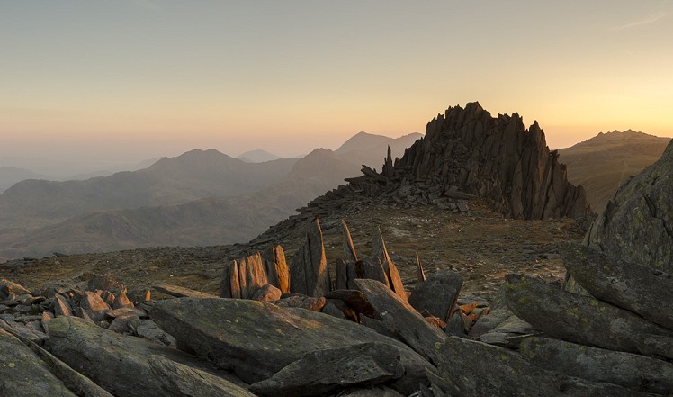
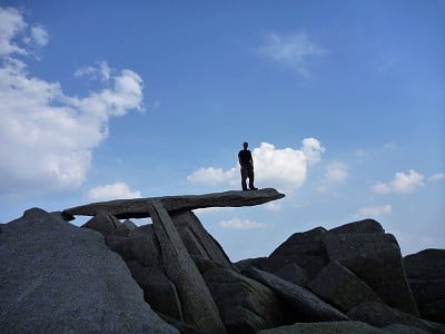
The majority of people tackle the Glyderau from the rugged northern side in the Ogwen Valley. To make a change, this route starts from the south side close to the famous mountaineering hotel of the Pen Y Gwyrd. Starting from this side give the walker the potential to be in the sun all day, which may be of benefit in the spring, autumn and winter, but might be best avoided on the hottest days of summer. The route follows the Miner's Track up, before traversing Glyder Fach and Glyder Fawr from east to west. To descend follow the more vague Red Dot Path (named locally after the red dots that can just be seen painted onto the boulders as waymarks), down to Pen Y Pass before descending to the Pen Y Gwryd. The route has amazing views as well as some unique and interesting rock features on the high Plateau of the Glyderau.
Detailed description
This has been viewed 8,101 times
Download
OS maps and some other mapping apps don't allow waypointsStatistics
Difficulty: ModerateDistance: 6.28 miles (10.10 km)
Total ascent: 848m
Time: 5 – 8 hours (Walking)
to rate this walk.
Additional Information
Start/Finish:Start by parking close to the Pen Y Gwryd. If you park just over the Conwy County border, then the lay-bys are not pay and display. If you do park in the pay and display parking these are policed by Gwynedd Council parking enforcement officers. The road is a clearway as well so don't just park on the side of the road, or if you do ensure all your wheels are off the tarmac to avoid a fine!, SH660560
Nearest town:
Llanberis
Terrain:
The terrain is generally rock and gravel paths heading up and over the summit plateau of the Glyderau. These are rough and rocky, and getting to the true summit of Glyder Fach in anything but dry weather is fairly problematic scrambling over large blocks.
Seasonal variations:
The higher sections the walk are likely to have some snow and ice during the often brief windows of winter weather. This can mean the route does not look too snowy from the road, but high up on the mountains, especially above 800m, winter can linger for a little longer. We would recommend an axe and crampons for those people attempting the route in winter conditions.
Weather and Hill Conditions: mwis: Snowdonia – Met Office: Snowdonia
Public transport:
Various Sherpa Buses go to the Pen Y Gwryd from Llanberis and Betws Y Coed.
Maps:
OS Explorer OL17 (1:25,000), OS Explorer OL18 (1:25,000), Harvey/BMC Snowdonia (1:40,000), OS Landranger 115 (1:50,000)
Accommodation:
The obvious place to stay is YHA Snowdon Pen y Pass 0345 371 9534
Find more Listings near this route
Tourist info:
Llanberis (01286 870 765); Beddgelert (01766 890615); Blaenau Ffestiniog (01766 830 360)
Further Routes
by Mark Reeves
- Snowdon via the Llanberis Path, and down the Snowdon Ranger 9 Oct, 2020
- Dolwyddelan - The Cwm Penamnen Horseshoe 10 Jul, 2020
- A Round of the Northern Carneddau 3000ers 11 Jun, 2020
- Maesglase, a Mid Wales Gem 24 Apr, 2020
- Moel Hebog to Moel Lefn 5 Mar, 2020
- Cwm Cneifion in Winter - Hidden Gully and Y Gribin 20 Feb, 2020
- Dartmoor - The North Moor from Princetown 12 Feb, 2020
- Snowdon Via the South Ridge and the Watkin Path 21 Dec, 2019
- The New Forest: Abbot's Well - Fritham Circuit 26 Aug, 2019
- The Atlantic Ridge of Carnedd Y Filiast 7 Aug, 2019


Typo - Bwlch not Blwch.