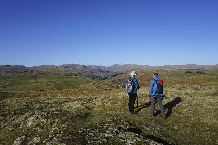
For any visitor to Kendal, this is the ideal quick retreat into the outdoors. These small hills are just to the north of Staveley, a village that is easy to reach by train, bus or car. The walk can be completed in an hour or two, is suitable for all the family, but still feels at times like a proper day in the Lakeland Fells. The three summits have a surprisingly wild feel to them, despite their easy access, and the views stretch from the Yorkshire Dales in the east, to the Coniston Fells and Langdale Pikes in the west.
Fetching Map
Height Profile
metres / Distance
miles
Detailed description
1
SD4694898829 From the lay-by, walk along the road back towards the village. Opposite Staveley Mill Weir, take the footpath on the right, signed towards Reston Scar. The path is steep at first, passing some cottages, and the rocky south-eastern flank of Reston Scar is soon visible on the right. After passing a few more cottages, a crossroads is met. Turn right here, on the obvious track that meanders uphill. Through a large gate, ascend the steep path to the ridge and follow this to the summit of Reston Scar.
2
SD4601398793 The views can be quite extensive from Reston Scar. On a clear day you will see the Howgills, the Forest of Bowland and much of the southern Lake District. As well as looking down on Staveley you should be able to see Kendal off to the south-east. From the summit, head north to go through a wooden gate, then follow the path through the burgeoning deciduous woodland. Through a tall gate, turn right and head up to Hugill Fell. The summit proper is easy to spot, but requires a slight detour from the main path.
3
SD4589199288 The Kentmere valley is due north from here, and the peaks that make up the Kentmere Horseshoe can be seen at the head of the valley. Walk north to the corner of the drystone wall, then go through the gate and follow the path east across boggy ground, where a selection of logs and pallets may allow your feet to stay dry. The rocky protuberance of Black Crag provides the third summit of the day, after which the path descends steeply back to the road.
4
SD4678399218 You could of course nip back right along the road here, but for a slightly longer, more scenic route with less traffic, turn left on the road, then cross Scroggs Bridge over the River Kent. Take the footpath to the right immediately after the bridge. Where this path joins the bridleway, turn right through Scroggs Farm to reach Hall Lane. Now turn right and follow this minor road back to Barley Bridge, overlooking Staveley Mill Weir.
This has been viewed 1,303 times
Download
OS maps and some other mapping apps don't allow waypointsStatistics
Difficulty: EasyDistance: 3 miles (4.80 km)
Total ascent: 196m
Time: 1 – 2 hours (Walking)
Voting:
from 1 votes
Login as Existing User
to rate this walk.
to rate this walk.
Additional Information
Start/Finish:Small lay-by just north of Barley Bridge. If arriving in Staveley by train, walk north from the station, past the village hall and up Silver Street/Kentmere Road. Follow this as far as Staveley Mill Weir. The path up to Reston Scar is on the left opposite the weir. If arriving by bus, the 555 stops beside the village hall. From here, head north up Silver Street/Kentmere Road to the weir, SD469988
Nearest town:
Staveley
Terrain:
Grassy paths in the hills, clear tracks lower down.
Public transport:
Staveley is easy to reach by public transport. The railway station is on the Windermere-Oxenholme line, with trains roughly every hour. Staveley is also a stop on the 555 bus route from Lancaster to Keswick via Kendal.
Weather and Hill Conditions:
mwis: Lake District – Met Office: Lake District Maps:
OS Explorer OL7 (1:25,000), Harvey/BMC Lake District (1:40,000), OS Landranger 97 (1:50,000) Directory Listings:
Find more Listings near this route Tourist info:
Windermere (015394 46499); Bowness (015394 42895); Kendal (0153 979 516)
Further Routes
by Chris Scaife
- Stoupdale Head and White Combe 28 Sep, 2023
- Keswick to Ambleside, via the Helvellyn range 26 Jul, 2023
- Black Combe 28 Jun, 2023
- High Rigg 29 Mar, 2023
- Kentmere Horseshoe from Kendal 29 Sep, 2022
- Lyke Wake Walk 21 Aug, 2022
- Whitbarrow 3 Jul, 2022
- Wild Boar Fell and Swarth Fell - a walk on the wild side 14 Jun, 2022
- Hawnby Hill - A Little Yorkshire Gem 1 Feb, 2022
- Kendal Fell, Cunswick Scar, and Scout Scar 20 Dec, 2021


It’s an oft overlooked landscape for visitors. Brunt Knott and Potter Fell on the opposite side worth a visit too; particularly Gurnal Dubs.
It's a shame the big cairn (Williamson's Monument) a little further north, isn't in CRoW access land. It's over a decade, but last time I went to look, the route shown in Wainwright's 'Outlying Fells' (High Knott, pg 18) was being 'discouraged'.