Lyke Wake Walk Walking

There aren't many walks out there that cross a national park via its widest part and over its highest points, all within one day, but that is rather the Lyke Wake Walk's modus operandi. Decades ago this challenging day walk was congested, and big steps were taken to reduce the vast numbers of people making the crossing. These days it is still walked, and there is an annual Lyke Wake Challenge race, but it is far less popular than it once was. In parts, particularly in the eastern half, it could now be described as peaceful. It still isn't easy though!

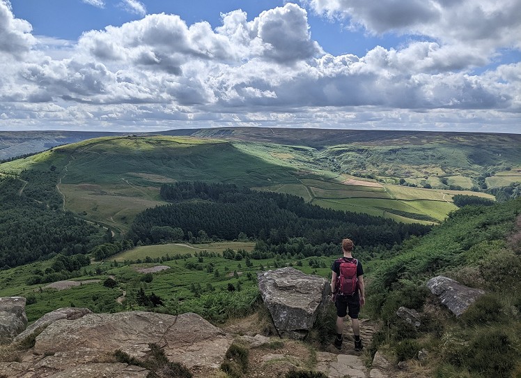
On Hasty Bank looking towards Round Hill, the high point of the North York Moors © Chris Scaife  © Chris Scaife
On Hasty Bank looking towards Round Hill, the high point of the North York Moors © Chris Scaife

See our article on this route

Fetching Map

Detailed description

1
SE4677099265 From Sheep wash car park, head north-west up Scarth Wood Moor to join the Cleveland Way. This waymarked, well-maintained national trail is followed for the next 12 miles, making navigation easy as pie. The first tumuli - ancient burial mounds - of the day are on the right of the path, about a kilometre after joining the Cleveland Way. If you miss them, don't worry - there'll be others. The Lyke Wake is almost exclusively a walk over open moorland ravaged for grouse shooting, but as if to trick you into thinking otherwise Scarth Wood Moor is followed by just over a mile of tree cover, following the wide track through Clain Wood. The bridge across Scugdale Beck is followed by a short section on a minor road, then the gentle ascent up to Carlton Moor.

2
NZ5190302569 Carlton Moor is one of a group of summits that the walk crosses at this northwestern frontier of the North York Moors. To the north, everything looks flat, and the industry of Teesside is hard to ignore. If it's clear, you should also be able to see the North Sea. The obvious path continues, up and down, up and down. After passing Lordstones Cafe, one of two dining options en route, the path heads up over Cringle Moor with its Falconer's Seat viewpoint, then on to the northern tip of Cold Moor, followed by the distinctive sandstone of the Wainstones on Hasty Bank. These ups and downs can be tough on the knees, but they don't go on forever. After descending from Hasty Bank, the route crosses the road near Clay Bank car park - often used as the first stop for service vehicles.

3
NZ5729103323 The next ascent is the biggest of them all - up to Round Hill, the highest point in the North York Moors, its summit home to a Bronze Age round barrow - but it is unlikely to cause any problems. After a short slightly steep section not far from the road, the gradient eases to strolling proportions. A gentle descent eastwards from here leads to Bloworth Crossing and now things really become easy, as the old mineral line is followed along flat ground all the way to the Lion Inn at Blakey. This second dining/drinking option more or less marks the halfway point of the Lyke Wake Walk.

4
SE6789899853 In your own time, head north up the road towards Rosedale Head for about a mile, then take the bridleway on the right to cut the corner and rejoin the road at Fat Betty Cross. You now want to head east-south-eastwards and there is a faint path to follow along the parish boundary, although most people stay on the road for this bit. Either way, just south of the junction with the Seavey Hill road, follow the obvious path east. White boundary stones lead the way across the often boggy Rosedale Moor, and tumuli abound. The path goes over the top of the best tumulus, Shunner Howe, before a gentle descent down to the minor road at Hamer.
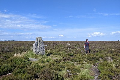
The ancient standing stone known as Blue Man-i'-th'-Moss  © Chris Scaife
The ancient standing stone known as Blue Man-i'-th'-Moss
© Chris Scaife

5
SE7440799490 The wide track is now followed eastwards over White Moor, past the Blue Man-i'-th'-Moss standing stone and Wheeldale Howe burial mound. The path narrows but remains obvious as it passes the Wheeldale Plantation and gradually descends to the Wheeldale Road. Many hours after the last real test of the knees, there is now a fairly steep descent to the stepping stones over Wheeldale Beck. A moderately steep ascent follows and after another mile or so you'll reach Simon Howe, with more round barrows. Underlining the retro nature of the Lyke Wake Walk, you may see a steam train on the North Yorkshire Moors railway line, which is crossed on the descent. On 40-mile walks, most people won't be looking for diversions, but Fen Bog - east of the railway line - is an excellent nature reserve and worth a wander if time is no object.

6
SE8577498259 After crossing the road at Eller Beck Bridge, the obvious path stays close to the beck and you'll soon reach Lilla Cross. This is one of the most distinctive landmarks of the walk and, if it's still daylight, the home straight should now be clear. The moorland is quite flat for a few miles, but the steep paths either side of Jugger Howe Beck give the last kneewreckers of the day. Once out of this impressive valley, plod along to the final road crossing at Stony Marl. Service vehicles often stop here, but the end is now firmly in sight. A triumphant victory march can now be made across Stony Marl Moor to the end of the crossing, the diminutive Lyke Wake Stone at Beacon Howes.

This has been viewed 1,636 times

Loading Notifications...
Facebook Twitter Copy Email