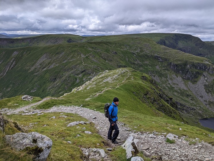
There are some walks in the Lake District that everyone with an interest in the outdoors really ought to do, and the Kentmere Horseshoe - or Kentmere Round as it is also known - is one of them. The walking is varied, the views are extensive, and there are numerous summits to enjoy. Walking the route from Kendal turns it into a real challenge, but this is certainly not a head-down test of endurance. The market town gives way to a scenic walk beside the River Kent up into the narrow valley of Kentmere, before joining the classic Horseshoe and including the oft-omitted peaks of Thornthwaite Crag and High Street, both of which are entirely worth the extra effort. Descending into Longsleddale, the walk now follows this tranquil yet rugged valley south, then takes a series of paths across the south-eastern part of Potter Fell back to Burneside and the return into Kendal.
See our article on this route
Detailed description
This has been viewed 1,537 times
Download
OS maps and some other mapping apps don't allow waypointsStatistics
Difficulty: SevereDistance: 32.25 miles (51.90 km)
Total ascent: 1,603m
Time: 12 – 18 hours (Walking)
to rate this walk.
Summits
Yoke 706 mIll Bell 757 m
Froswick 720 m
Thornthwaite Crag 784 m
High Street 828 m
Mardale Ill Bell 760 m
Harter Fell 778 m
Kentmere Pike 730 m
Shipman Knotts 587 m
Additional Information
Start I have described this route from Kendal Town Hall, but you can start from anywhere in Kendal. Just head north, to join the riverside path on the west bank of the River Kent. You could of course start in Burneside if you wanted to make the route a couple of miles shorter, SD514927; Finish , SD514927
Nearest town:
Kendal
Terrain:
Pavements beside roads and paved riverside paths to Burneside, then along obvious footpaths beside the River Kent. A bit along minor roads - almost traffic-free - either side of Staveley, then path up to Kentmere. The Kentmere Horseshoe is a well-walked path, although the eastern part, from Harter Fell down to the byway leading into Longsleddale is less clear and can be boggy. Easy walking along a bridleway through Longsleddale is followed by a track zigzagging up through woodland, then across towards Potter Fell, and a bridleway past the farm down to the road.
Seasonal variations:
The Kentmere Horseshoe can be an exposed place in bad weather. This is going to be a big day, so it's best done when the days are long. Having said that, the first and last few hours are at low altitude so starting in - or being overtaken by - darkness won't necessarily cause problems.
Weather and Hill Conditions: mwis: Lake District – Met Office: Lake District
Public transport:
Kendal railway station is just one stop away from Oxenholme Lake District on the West Coast Main Line. There is also a station in Burneside but, as mentioned above, that will reduce the length of the walk by a few miles. Kendal is well served with buses and the bus station is about a five-minute walk from the Town Hall.
Guidebooks:
Maps:
OS Explorer OL5 (1:25,000), OS Explorer OL7 (1:25,000), Harvey/BMC Lake District (1:40,000), OS Landranger 90 (1:50,000), OS Landranger 97 (1:50,000), OS Landranger 96 (1:50,000)
Directory Listings:
Find more Listings near this route
Tourist info:
Kendal (0153 979 516); Killington Lake (015396 20138); Windermere (015394 46499)
Further Routes
by Chris Scaife
- Stoupdale Head and White Combe 28 Sep, 2023
- Keswick to Ambleside, via the Helvellyn range 26 Jul, 2023
- Black Combe 28 Jun, 2023
- High Rigg 29 Mar, 2023
- Reston Scar, Hugill Fell and Black Crag 15 Nov, 2022
- Lyke Wake Walk 21 Aug, 2022
- Whitbarrow 3 Jul, 2022
- Wild Boar Fell and Swarth Fell - a walk on the wild side 14 Jun, 2022
- Hawnby Hill - A Little Yorkshire Gem 1 Feb, 2022
- Kendal Fell, Cunswick Scar, and Scout Scar 20 Dec, 2021


That's a good, hefty outing, Chris. It wasn't until a few years ago I realised Kendal = Kentdale = Kentd'l so this seems like a logical starting-point.
Hefty outing with plenty of variety too. It’s a great suggestion.
Thanks so much for adding this, Chris. I was looking for a lower down walk one day this summer as the tops were covered in cloud and the walk to Kentmere reservoir and back was thoroughly enjoyable. I hope it's not considered a thread jack to post pics of that here. Just as an added bit of context as to what is available in the area near Kentmere:)