


Destination Hillwalking in Wild West Texas
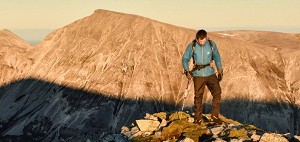
In Spring 2022, Munroist Ian Robertson went to the desert hills of west Texas in search of something a bit different, and ended up having one of the best trips of his 30-year hillwalking career.
England's highest summits outside the Lakes; the wildest and most uncompromising country south of Scotland; the largest land-based National Nature Reserve; the second largest Area of Outstanding Natural Beauty, and more mud than a WWI battlefield. The North Pennines don't do subtle, but it's worth digging beneath their harsh exterior. These are surprising hills.

I'm not ashamed of the odd sneaky cheat. A bog trot along the North Pennine watershed is hard enough, so you'd be nuts not to capitalise on the old road that hairpins over the Hartside Pass from Melmerby to Alston, England's highest 'town'. Assuming it's not closed by snow. I let the car take the strain to England's highest caff, a lone building on top of the pass at well over 500 metres, then stride south into the frosty nip of a March morning.
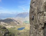
The hills here swell like a giant wave over the low lying Eden Valley to give what could be England's most spacious view. The abrupt contrast between the barren heights above and the rich farmland below is striking, the escarpment so massive that it generates its own weather phenomenon, the only named wind in the British Isles. The north-easterly Helm Wind pours down-slope like a waterfall of air, but often the gale is oddly localised, and a few hundred metres from the base of the hills the trees barely rustle. When the summits carry a distinctive cloud cap, the Helm Bar, expect an ascent from the Eden Valley to be a bit of a battle.

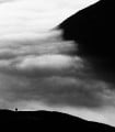
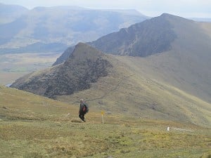
Today it's still and cloud free. Banks of fog hug the patchwork fields below, and beyond them the Lakeland skyline rises like an island. There are hints of Galloway, a glimpse of The Cheviot, and a glaring sun that brings no warmth. From the interestingly-named Fiend's Fell the frozen ground bulges gradually towards Cross Fell, the moorland dotted with man-sized cairns and the long-abandoned scratchings of hardy miners.
The escarpment is so massive that it generates its own weather phenomenon, the only named wind in the British Isles
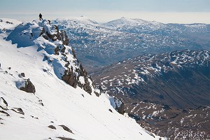
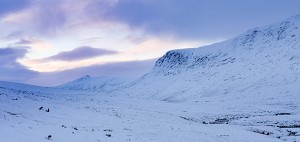
At nearly 900 metres, Cross Fell is England's highest summit outside The Lakes, a domed roof capping a great sprawl of peat bog and heather that makes up the largest and least hospitable expanse of wild high ground south of the Scottish border. There's nowhere bleaker this side of Siberia, but the starkness is so total that it's inspiring. The height and inland position of the range bring plenty of snow, and it's no accident that most of England's ski tows (for what they're worth) are found hereabouts, while the rolling nature of the landscape is well suited to ski touring too. Hillwalkers seeking reliably wintry ground won't do better than Cross Fell.
The superlatives don't ends there. The North Pennines enjoy protected status as an Area of Outstanding Natural Beauty covering nearly 2000 square kilometres. Second in scale only to the Cotswolds and larger than most British National Parks, the AONB splays wide between the Yorkshire Dales and the Tyne Valley. The area also hosts Britain's first European Geopark, a founding member of the Global Geoparks network. It's an obscure designation perhaps, but rock fans will dig the complex geology underlying these hills, a mix of carboniferous limestone, sandstone and shale, shot through with the columnar dolerite of the famous Whin Sill and some remarkable mineral veins. It's mostly hidden under peat of course.

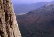
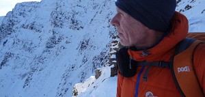
Cross Fell is well named, sucking in more than its fair share of angry weather. Clear days like today should be treasured. I skitter up a slope of spring-fed ice onto the summit plateau, a broad green table dusted with crusty snow. I've joined what must be the most challenging leg of the Pennine Way, which treads long desolate miles over this biggest and baddest of the Pennines, linking Dufton in the Eden Valley with Alston in the middle of nowhere. More of those weird man-size cairns mark the route down to Tees Head, where a major river is born (no prizes for guessing). I'm on the spine of England; westwards the land drains into the Irish Sea, while looking east the brown-purple wastes slope off into Durham and the distant North Sea. The Tyne and the Wear also seep from the North Pennine muck, so in a sense we've got these hills to thank for the existence of several northern towns.
'Look beneath their forbidding appearance and these moors turn out to be surprisingly rich'
There's no sign of urban grot up here though; just lots of nature. A sign marks the edge of the Moor House - Upper Teesdale National Nature Reserve. Britain's largest land-based NNR, this cross section of upland-to-valley includes more than 20 species of European importance and a variety of habitats from summit heath and peat bog to low lying hay meadows and juniper wood. These support an internationally significant bird population including 10,000 pairs of breeding waders and 80% of England's black grouse. Look beneath their forbidding appearance and these moors turn out to be surprisingly rich.

A linear walk – transport needs to be prearranged. From Hartside Pass just follow the high ground southeast as far as you fancy; descent trails to the Eden Valley are available at a number of points. Paths are intermittent on Fiends Fell and Melmerby Fell, but the highest section over Cross Fell, Little Dun Fell, Great Dun Fell and Knock Fell makes use of the well trodden Pennine Way. Then it's trackless peat bog hell to High Cup, where a different leg of the Pennine Way is met leading down to Dufton.
For a more detailed description see this UKH Route Card:

Follow the farm track towards Cross Fell, passing through a couple of gates and climbing increasingly steeply around the north side of High Cap. Beyond some disused mine workings the track dwindles to a path, continuing over boggy moorland to a broad shoulder just north of Cross Fell's summit dome. Bear right to join the Pennine Way for the final ascent to the summit trig and wind break. Stay with the Pennine Way down to Tees Head, then cut right on a less well used path which makes a long and enjoyable descent over Wildboar Scar. From the muddy fields below the hills cut through Ranbeck farm to return to Kirkland.
For a more detailed description see this UKH Route Card:

From the east end of the village take the Pennine Way east on an uphill track past Bow Hall farm. Stay with the track until it ends in old quarry works on Peeping Hill, from where the Pennine way continues uphill to reach the edge of the High Cup cliffs. Follow the rim to High Cup Nick, the broad gully at the back of the cirque, then leave the Pennine Way and take the opposite rim, where the path is much less clear running along an obvious terrace. Just before a drystone wall it's possible to make a quick there-and-back climb onto Murton Fell (boggy; big summit cairn). Back at High Cup cross a stile over the drystone wall and follow the escarpment edge out to the promontory of Middle Tongue. Descend its end through broken crags, then cross the valley of High Cup Gill and climb back up to rejoin the Pennine Way.
Having passed the giant golfball radar station at Great Dun Fell (highest surfaced road in the UK - spot a theme emerging?) the Pennine Way continues onto Knock Fell. Here it wisely drops out of the hills. I soon understand why. The North Pennines enjoy the proud distinction of boasting over a quarter of England's blanket bog, and most of it seems to be located between Knock Fell and High Cup. Peatlands are an internationally important habitat and a significant carbon sink. According to the National Trust they are the single largest carbon reserve in the UK, storing around 3 billion tonnes of the stuff; more than can be accounted for by the forests of Britain and France combined. The flipside is that peatlands actually become carbon emitters if damaged by overgrazing or drainage. Drainage? If only. I'm lost in a giant quaking jelly of moss and mud, weaving a way between oozing groughs and black pools. On the peaks between the peaty troughs I catch glimpses of Mickle Fell, a snowcapped hump that taunts me by never seeming to get closer. Nightfall seems imminent and still there's no end in sight.
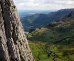
Suddenly the ground ahead opens up, dropping into the canyon-cum-corrie of High Cup, an anomaly in the otherwise-rolling North Pennine landscape. It would be no exaggeration to call this one of the natural wonders of England, an almost perfectly symmetrical glacier-scooped bowl ringed with a line of tottery dolerite cliffs. It's big, and there's nothing else quite like it. I've rejoined the Pennine Way now, and it's only a half hour downhill jog to Dufton where I happen to know a good pub.

 © Dan Bailey
OS Landranger (1:50000) 91; OS Explorer (1:25000) OL 19 and OL 31
Walking in the North Pennines by Paddy Dillon (pb Cicerone); a comprehensive guide to day walks in the area, from high level to the valleys, though it doesn't include the watershed route described here.

Free
At about 700m up on the north flank of Cross Fell, Greg's Hut (NY690355) is one of England's few bothies. Spartan but well placed for the Pennine Way and the watershed walk.
Budget
Dufton YHA, tel 0845 3719734; Alston YHA, tel. 0845 3719301 or visit YHA website
Comfort
Kirkland Hall holiday cottages, in the tiny hamlet of Kirkland at the foot of Cross Fell, tel. (01768)88295
articles_author()]
In Spring 2022, Munroist Ian Robertson went to the desert hills of west Texas in search of something a bit different, and ended up having one of the best trips of his 30-year hillwalking career.

Daft online reviews occasionally make it into the mainstream media, and they don't get much sillier than complaints about mountains. Since we're not above laughing at the less hill-savvy, we've mined Tripadvisor for some...


Comments