


Destination Hillwalking in Wild West Texas
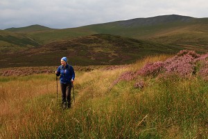
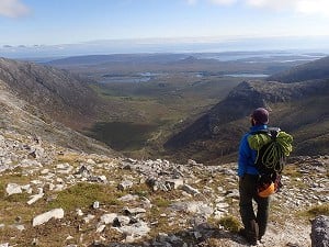
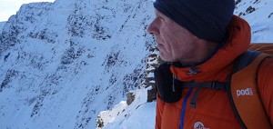
In Spring 2022, Munroist Ian Robertson went to the desert hills of west Texas in search of something a bit different, and ended up having one of the best trips of his 30-year hillwalking career.
Are you planning a post-Covid hill trip to Ireland? Well you probably should be... and here's the ideal place to start.
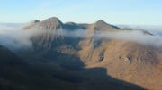
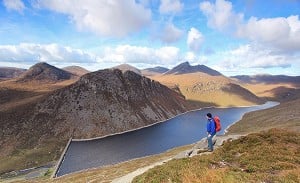
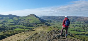
With its contorted crags, jewel-like lakes and spectacular ridges, Brandon Mountain (alternatively known as Mount Brandon) is a must-do for any self respecting hillwalker. Save it for a clear day, says Mike Dixon.
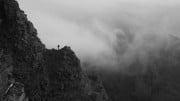
My first impressions of Irish mountains were clouded, literally so for most of two weeks, which put me off returning for eight years. Even then I visited Corsica just before to guarantee some sunshine during my summer holiday. Boarding the late train to Holyhead at Colwyn Bay station for that second trip I was nearly blown back onto the platform when I opened the carriage door and the alcohol fumes hit me. The ferry deposited us hungover early next morning, and after several strong coffees we located the car hire depot in Dublin centre. From there it was a long drive to Tralee on the west coast and a miraculous apparition: the five mile escarpment of Brandon Mountain on the Dingle Peninsula crystal clear.

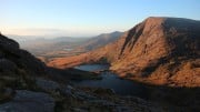
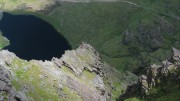
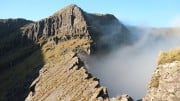
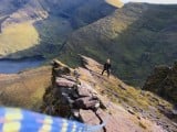
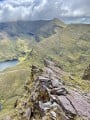
My friend was there mainly for the fishing, and while he settled in for a convivial first evening in Cloghane I headed for a peak with a very high reputation. It didn't disappoint - especially by the East (Faha) Ridge, a classy high-wire affair from which to appreciate the black coum falling from the summit and the rosary bead lakes adorning the different levels under it.
On the short final stretch to the summit along the mountain's main spine, the peak revealed its dual character. It reminded me a bit of Ladhar Bheinn with its own two contrasting sides. To the east it's precipitous and deeply sculptured. Behind the fantastic ridge I'd just traversed, the sweeps of Brandon and Tralee Bays are separated by the snaking arms of the Maharees peninsula. To the west, gentle slopes run almost to the sea where they are punctuated by headlands, jagged low tops, rounded small hills and an extensive scatter of houses. Beyond that are a sprinkle of small but highly individualistic islands off Dunmore Head, the tip of the Dingle peninsula. All this along with the array of peaks inside the Ring of Kerry to the south was rapidly erasing past memories of a mist-enshrouded country.

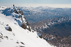
Brandon is the kind of peak that draws you back, and for me each time by the Faha Ridge, a classy high-wire affair
I made two mistakes that evening; the first in thinking that the islands out west were the Skelligs, the other in my choice of return route. It seemed a shame not to enjoy the sunset, so I continued along the ridge to the lower but equally spectacular summit of Brandon Peak. The descent of its own East Ridge started easily but the lower buttress was more an act of faith as it steepened too much for comfort [in ascent, taking the difficulties direct, this ridge makes a brilliant mountaineer's scramble - Ed]. At the bottom a minefield of huge boulders had to be crossed in darkness before a cruel ascent to the car at Faha. A pint of Guinness never tasted so good.
The effusions of Jim Perrin, Hamish Brown and Cameron McNeish had lured me here and I owe them thanks. I had just become a life member of the Brandon appreciation society. But the real doyen of the Irish landscape was a local, Robert Lloyd Praeger. Anyone who has dipped into his classic 1937 work The Way That I Went will be enticed to destinations all over the country through the power of his descriptions. It's a brilliant piece of unintended marketing as well as being highly informative. He championed Brandon as Ireland's finest mountain, which many would concur with. Those intent on climbing the Furth Munros and having travelled a distance to do so will often tackle it regardless of weather. Several I know wonder what all the fuss is about but sadly their ascents were in the ubiquitous cloud.

Brandon Mountain can be a conundrum for fair weather watchers. It seems to be a real lodestone for mist. After my ascent of Brandon, the following day was similarly flawless and we gravitated to the adjacent and largest peninsula in the area to climb Ireland's two highest peaks in a natural circuit from Loch Acoose. Under blue sky all day we couldn't help noticing a cloud cap on Brandon which we thought would naturally burn off. It didn't and by mid-day had lowered, the only peak in the area to be tainted so. Guidebook writer Paddy Dillon had a beautiful evening ascent of Brandon like my own, during his extended walk to climb all the 2000 feet peaks in Ireland. He was lucky, as up until that day Brandon had remained shrouded in cloud for four weeks. The moral of this is obvious: Don't waste good weather in this part of the world.
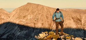
Faha Ridge
Brandon is the kind of peak that draws you back, and for me each time by the Faha Ridge. On that first ascent I crossed a slabby section like the apex of a roof and was confronted by an abrupt drop, the Bad Step. A peg and a piece of tat put me off, not helped by uncertainty as to the correct point at where to start down climbing.

The second time I was deterred by damp rock. However after following the normal, worn detour descent to the side I decided to check it out. It's clearly easier in ascent with the hardest move, a long stretch, at the bottom and then a series of straightforward steps. Nevertheless it's not a place for error and like the trickier sections of the Cuillin Ridge, a fall unroped could be very serious. It was only on my third time that I down climbed the section, but even then locating the starting point was not obvious.
Scrambling circuit
Climbing neighbouring Brandon Peak by its East Ridge, continuing to Brandon Mountain's main summit and then descending its Faha Ridge would give you the longest and most comprehensive scrambling tour of the mountain. As a bonus you'd also get to do the Bad Step in ascent.
Full traverse
Linking all the mountain's main tops is also a grand excursion, said by many to be Ireland's greatest ridge walk. From the northern seaside sentinel of Masatiompan, head over Brandon, Brandon Peak and Ballysitteragh to the Connor Pass road. Done the opposite way you could continue to Brandon Point and dip your toes in the Atlantic to finish. Either way, transport would need to be pre-arranged.

The Blasket Islands off the western tip of the Dingle peninsula are the icing on the cake of the area
Named after early Christian Saint Brendan, Brandon Mountain has a strong religious significance, as well as a mountaineering one. Masses are held on its summit, and there are 'pilgrim' routes to the summit from both the east and the west sides. I really don't mind the religious bling of the shrine at the start, nor the summit cross, but the waymarking in between is jarring.
After my second ascent I returned by way of the magnificent eastern coum via the Pilgrims Path back to Faha. Despite the spectacular setting, I was disappointed by the clutter. First of all there was a post with 'down' inscribed on it. Further on was the sight of arrows painted on the rock pointing the way. Arrows neither small nor discreet, multi-coloured to add variety. Arrows all over the place! Expletives machine-gunned from me like Father Jack and ricocheted around the coum. The arrows are superfluous; the path is obvious and the section through the rock shelves is worn. Lower down a trail of marker posts, again redundant, led to the road.
In the UK (and Ireland) I'm always glad we've retained mountainous terrain where in the main you still have to employ route finding skills even at a basic level instead of looking out for the next paint flash. There's something satisfying about doing so. You might be following a path anyway, but posts and paint reduce the natural state further and seem almost an act of desecration, making a mockery of the sign in the car park asking you to respect the mountain environment. Imagine the painters let loose somewhere similar like a Skye corrie.

Nearest towns: Tralee or Dingle
Best base: The village of Cloghane at the eastern foot of Brandon is well set up for visitors, with accommodation and places to eat.
Getting there and getting around: Public transport is just do-able - bus from Tralee to Cloghane. It's much more convenient to have your own vehicle, which means either the ferry and a drive across Ireland or a flight and hire car. The nearest airport is Cork, from where it's a fairly easy drive to the Brandon area.
Maps: OSi 1:50,000 Discovery Series sheet 70
OSi 1:25,000 Brandon Mountain
Guidebook: The Dingle Peninsula - A walking Guide, by Adrian Hendroff (Collins Press)
Subsequent visits have led me to explore other hills on the Dingle Peninsula. The Slieve Mish Mountains and Beenoskee/Stradbally Mountain group are two very worthwhile outings and would be better known were it not for their illustrious neighbour. It's the drama of that eastern aspect of Brandon which always captures the gaze; a giant curtain of black coums, ridges and loughs.
I've also been drawn west to a place not even 300 metres high, but with its own special magic. The Blasket Islands off the western tip of the Dingle peninsula are the icing on the cake of the area.

The shortest crossing is from Dunquin which houses the Blasket Centre with information on all aspects of the archipelago. We opted for a full day trip from Dingle entertained by the famous Fungi the dolphin leaping out of the water at the mouth of the harbour. Such is the pull of this bottlenosed dolphin that I wouldn't be surprised if the town was already secretly training up his future replacement. The geology of the south coast is a further attraction en route to the islands, including one world class example of desiccation (or mud) cracks preserved in Devonian bedrock, a vertical tile-like panel in a beautiful eggshell blue.
The boat took us out for a close up of two of the constituent islands, Inishvickillane and Inishnabro. Former Taoiseach Charlie Haughey had a house built on Inishvickillane and used it as a holiday home where guests like French President Francois Mitterrand were entertained. Inishnabro has a remarkable arch through twin tops like cathedral spires on a promontory on the island's north side. This is all good value as a route to the main destination.

Great Blasket was inhabited until 1953, an Irish speaking fishing community which at its peak was home to 175 people. Its most famous resident was storyteller Peig Sayers who dictated 350 ancient legends, ghost, folk and religious stories to the Irish Folklore Commission. Human signs stretch back much further with the Iron Age promontory of An Dun dated to 800 BC. There is an air of sadness hanging over the ruined village on Great Blasket. Spirits soon rise on a good day with the beauty of its setting above the sands of An Traigh Ban. If disturbed, the colony of seals lazing like great slugs on the beach will make a mass exodus to the surrounding turquoise waters.

The main backbone of the island provides an exhilarating walk over the top of Slievedonagh to the high point of Croaghmore (292m), in places pleasantly narrow but non serious. Its position is wonderful, with views to the Iveragh peninsula and the mellow, green, west side of Brandon. Of the five other Blaskets around you it is Tearaght Island which is the most arresting, a remarkable sharp double point, the westernmost of all Ireland's islands. It was this island that I mistook for the Skelligs on my first evening ascent of Brandon Mountain, so similar in appearance is it to Skellig Michael. It left me wondering how to get out there one day.
Of course I'll be back and to Brandon too. I've noticed crampon scratches on its Faha Ridge, and felt envious. The main omission I have is an ascent in winter, if not by the ridge then a climb up the headwall to emerge right by the summit cross. On that day perhaps there'll be snow on the Blaskets too? The stuff of dreams.
Accommodation Advertise here
No Premier Listings found in this area
Instructor/Guides Advertise here
No Premier Listings found in this area
Outdoor Shops Advertise here
No Premier Listings found in this area
In Spring 2022, Munroist Ian Robertson went to the desert hills of west Texas in search of something a bit different, and ended up having one of the best trips of his 30-year hillwalking career.

Daft online reviews occasionally make it into the mainstream media, and they don't get much sillier than complaints about mountains. Since we're not above laughing at the less hill-savvy, we've mined Tripadvisor for some...


Comments