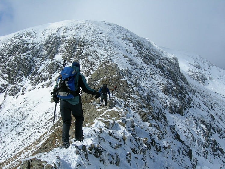
Overwhelming popularity cannot diminish the spectacular class of England’s finest ridge walking horseshoe, a circuit of the chiselled crests cupping the Red Tarn cove. Though hands-on challenge is very limited the name Striding Edge seems apt as you lope along its airy spine; ridges might come harder but they don't get better. To beat the crowds avoid weekends and bank holidays at all costs; misanthropes might prefer a lonely dawn start. For best results mountaineers should save this round for winter; it's very much easier in summertime (airy, but only borderline graded scrambling).
Fetching Map
Height Profile
metres / Distance
miles
Detailed description
1
NY3956415928 From the A592 in Patterdale follow the single track road up Grisedale, climbing a steep hill and passing a house and a wooded dell. Just beyond the trees turn right on a side track, crossing a bridge to reach a gate on the edge of a field. Take the path through the field. Beyond a stone wall this swings left to make a long rising traverse up Grisedale's northern slope (a bit of a trudge if there's soft snow). At about the 710m contour is the so called Hole-in-the-Wall, actually a stile; cross this.
2
NY3592715510 The Red Tarn face of Helvellyn is now visible ahead. From the path junction take the route southwest along the broad crest. The ridge soon narrows into Striding Edge.From a minor top the crest continues as a gently serrated curving knife edge. Though it only demands very basic scrambling Striding Edge has a superbly airy feel (if you're really averse to heights a get-out path slinks along the N flank). Cross a level rock 'pavement', then continue over little bumps to reach a short downclimb just before Striding Edge meets the main mountainside. Negotiate this via a short broken groove on the left – polish shows the way. Beyond a little gap is a final rocky barrier, which can be skirted on the right or taken direct. A steep slope now leads to the summit plateau. From the memorial cairn at the top of this slope follow the plateau rim to the summit windbreak.
3
NY3424415067 Continue north along the edge, passing a trig point to reach a marker cairn above the drop-off point (hopefully not literally) for Swirral (not 'squirrel') Edge. Though shorter, this is a worthy twin to Striding Edge. Initially the descent is fairly steep and needs caution if it's icy or corniced. Sticking with the crest, scramble down a broken rock buttress to reach easier ground. The ridge remains sharply pronounced for a while, though an avoiding path soon appears on the southern flank if you prefer. Beyond a shallow rise is a small col, and the end of the good stuff. The outlying pyramid of Catstye Cam can be bagged from here in about 10 minutes (optional). Back at the col, a well trodden path drops quickly into the cove.
4
NY3504615422 Cross the outflow from Red Tarn and continue beneath the northern slope of Striding Edge back to Hole-in-the-Wall. Return the way you came.
This has been viewed 28,365 times
Download
OS maps and some other mapping apps don't allow waypointsStatistics
Difficulty: DifficultDistance: 7.71 miles (12.40 km)
Total ascent: 915m
Time: 6 hours (Walking)
Voting:
from 12 votes
Login as Existing User
to rate this walk.
to rate this walk.
Additional Information
Start/Finish:private pay and display car park opposite the Patterdale Hotel; alternatively start in Glenridding, NY395159
Nearest town:
Ambleside or Penrith
Terrain:
Well trodden paths throughout. The edges themselves are airy and narrow, with plenty of exposure and some very easy scrambling at a low grade 1.
Seasonal variations:
Under snow this becomes a grade I mountaineering round (only just), and a real classic. Though very low in the grade it is frequently underestimated, and avoidable mishaps occasionally befall the underequipped (crampons and an axe are recommended). Be aware of any avalanche risk on the slopes leading from Striding Edge to the Helvellyn plateau, and watch out for cornices here and on the descent to Swirral Edge - which can also be very icy at times.
Weather and Hill Conditions: mwis: Lake District – Met Office: Lake District
Public transport:
Occasional infrequent buses from Penrith to Patterdale
Guidebooks:
The Ridges of England, Wales and Ireland, Dan Bailey, pb.Cicerone http://www.cicerone.co.uk/product/detail.cfm/book/539/title/the-ridges-of-england--wales-and-ireland/refer/ukh
Maps:
OS Explorer OL5 (1:25,000), Harvey/BMC Lake District (1:40,000), OS Landranger 90 (1:50,000)
Accommodation:
Patterdale Youth Hostel 0845 3719337; Helvellyn Youth Hostel 0845 3719742; Sykeside campsite near Brotherswater 017684 82239; Gillside campsite and bunkhouse in Glenridding 017684 82346; School House B&B Patterdale 01768 482887
Find more Listings near this route
Tourist info:
Ullswater (017684 82414); Grasmere (015394 35245); Pooley Bridge (017684 86530)
Further Routes
by Dan Bailey UKH
- Beinn Dorain and Beinn an Dothaidh 5 Feb
- East Ridge of Beinn a' Chaorainn and Beinn Teallach 21 Jan
- A' Chralaig and Mullach Fraoch-choire 4 Dec, 2023
- Meall na Teanga & Sron a' Choire Ghairbh - The Loch Lochy Munros 6 Nov, 2023
- Bynack More 19 Oct, 2023


