
Rocktype UNKNOWN
Altitude 517m a.s.l
Faces N
Final pitch of Blue John Rib, Mam Tor © Colin Wells
Summit of this hill
This summit is listed in Peak District 400s, Deweys (England), Peak District 400\'s - Revised, Pennine Peaks, The Ethels of the Peak District, Peak District Trigs hill lists.
This summit has been climbed in 537 logbooks.Hill features
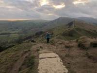
Mam Tor is a 517m hill near Castleton. Its name means 'Mother Hill', so called because frequent landslips on its eastern face have resulted in a multitude of 'mini-hills'Â beneath it.
The crag is situated on the southeast face of Mam Tor and is impossible to miss, dominating as it does the Hope Valley and seen as soon as one breasts the crest of surprise view several miles away when approaching from the east. The ground is loose, broken and treacherous in most conditions. Probably best summed up in the wise words of the late, great Paul Nunn who declared: 'A shale-built slag-heap of inveterately crumbling rubble.'
The face is only probably comparatively safe after several days of hard frost and cloud cover has prevented the sun from appearing. The routes are therefore normally climbed, on the scarce occasions they are, under winter conditions.
Approach notes
Park at the car park on Rushup Edge, walk towards the Winnat's Pass then walk down the road under the face. Cross the fence at a stile and follow to the face in 20 minutes.
Route Cards
 | The Edale Skyline from Hope 19.08 miles, 1,122m ascent, 4 – 10 hours. Edale or Hope. | |
 | Edale to Mam Tor 3.38 miles, 267m ascent, 1:30 – 2:30 hours | |
| List more walks, runs & bike rides | ||
| There are no comments from visitors to this hill. |
Summits, Scrambles, and Easy Climbs on this hill
| Name | Grade | Stars | Type | Logs | Partner Ascents |
|---|
These routes you have climbed by seconding or top-roping.
These routes you have Dogged.
These routes you Did not Finish.
Routes are waiting to be checked by a crag moderator, and may not be accurate. Routes can't be verified by a crag moderator, and they need more information to confirm it. Routes are no longer climbable.