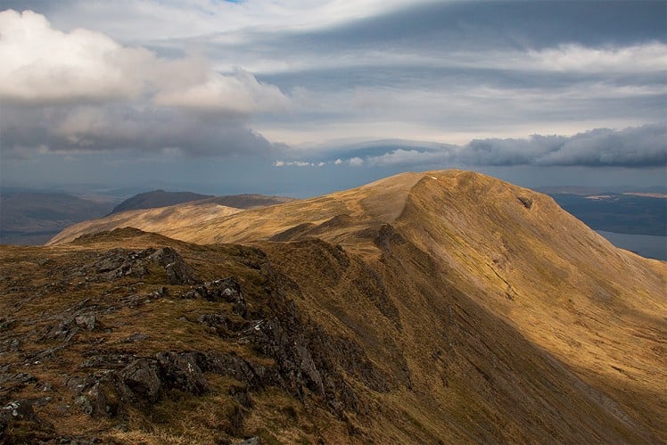
Mull's only Corbett, Dun da Ghaoithe is a dramatic seaside hill with huge views encompassing both the mainland and the island's rugged interior. A shorter ascent is possible from Scallastle, but the extended circuit descried here is a better route with more in the way of ridge walking.
See our article on this route
Fetching Map
Height Profile
metres / Distance
miles
Detailed description
1
NM7267934989 Follow the track for Upper Achnacroish, immediately taking the right fork where it splits. The track zigzags steeply uphill through woods, then crosses open ground to pass the farmhouse. Beyond a locked gate and stile the track winds uphill, passing a forestry plantation and then climbing more steeply to the transmitter station on Maol nan Uan. This may not be pretty but the sea views more than compensate.
2
NM7026935844 Beyond the first transmitter the track continues up a broad grassy ridge with an outlook across the huge bowl of Dun da Ghaoithe's eastern corrie. Dun da Ghaoithe is the right hand of the mountain's two peaks, though from here the lower but sharper Mainnir nam Fiadh looks the more attractive. A steady plod soon brings you to a higher transmitter mast.
3
NM6916135231 Leave the track behind now and strike west up pathless grassy ground. Beyond a broad minor top the ridge gets narrower and rougher underfoot. Pass through some distinctive rock bands, then climb more steeply up onto the well defined crest that leads to the massive cairn on the summit of Mainnir nam Fiadh.
4
NM6761535357 Follow the broad grassy ridge north-northwest along the corrie edge for the short descent into a slight col, and then the easy climb onto Dun da Ghaoithe. This translates as Fort of the Two Winds, and it's well named. The summit is often said to have the best views of any on Mull; I'm not going to argue.
5
NM6723836217 It is possible to descend the east ridge, Maol nan Damh, but its initial craggy slope is not obvious from above. Instead head roughly north, before bearing right onto the broad northeast ridge, Beinn Chreagach. This gives an easy descent, with an occasional little outcrop to negotiate. As the ridge loses definition trend east down rough tussocky ground. A very vague trail descends the left bank of a burn past a waterfall, then drops through open woodland to join a muddy track near the Scallastle River.
6
NM6961637527 Pass through Scallastle farm to reach the A849. It's not just a long easy road walk through Craignure and back to the start point.
This has been viewed 914 times
Download
OS maps and some other mapping apps don't allow waypointsStatistics
Difficulty: ModerateDistance: 10.56 miles (17 km)
Total ascent: 857m
Time: 5 – 6 hours (Walking)
Voting:
from 1 votes
Login as Existing User
to rate this walk.
to rate this walk.
Additional Information
Start/Finish:Park by the A849 near turnoff to Duart Castle (limited spaces), NM726350
Nearest town:
Tobermory
Terrain:
Easy vehicle track to start, then open hillside with frequent boggy ground and only intermittent paths.
Public transport:
Ferry to Craignure - step off the boat practically straight onto the hill
Weather and Hill Conditions:
mwis: West Highlands – Met Office: West Highlands Maps:
OS Explorer 359 (1:25,000), OS Explorer 375 (1:25,000), OS Landranger 49 (1:50,000) Directory Listings:
Find more Listings near this route Tourist info:
Craignure (08452 255 121); Oban (01631 563 122)
Further Routes
by Dan Bailey UKH
- East Ridge of Beinn a' Chaorainn and Beinn Teallach 21 Jan
- A' Chralaig and Mullach Fraoch-choire 4 Dec, 2023
- Meall na Teanga & Sron a' Choire Ghairbh - The Loch Lochy Munros 6 Nov, 2023
- Bynack More 19 Oct, 2023
- Beinn a' Mhuinidh 4 Oct, 2023


Dun da Ghaoithe is a great walk. A few years ago we did a complete south north traverse. Left the car at the cemetery at Pennygown , caught the bus to Craignure and then walked back over all the hills. Fantastic views over the Sound of Mull watching the snow showers barrelling through.
Just spotted this. Isn't Beinn Tallaidh a Corbett as well? Or has it been demoted?
It got demoted quite a while ago. Some bedtime reading https://www.hill-bagging.co.uk/surveys/Survey%20of%20Beinn%20Talaidh.pdf
Possibly only 20cm short - close, but no cigar!
I set off from near there one Saturday afternoon in December years ago. Walked up the ridge and saw a nice sunset from the top. Went down into Glen Forsa and struggled through the forestry ditches in the dark before finding the track, torch was in the car.