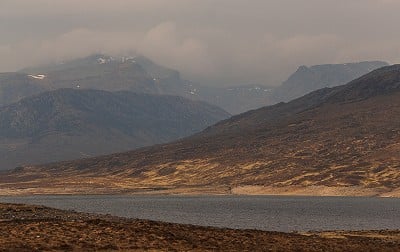
The highest peak north of the A835 road to Ullapool, Beinn Dearg is big and complex, with some impressive cliffs and corries. Its smaller neighbour Cona' Mheall looks its best from said road, with the craggy south ridge seen end-on from around Loch Glascarnoch. Probably most often climbed in a four-Munro day from Inverlael, the pair make arguably a more satisfying challenge when done from the south, a circuit that allows for an ascent of Cona' Mheall's ridge. This lovely low-end scramble in a wild setting is worth the bog fest on the approach. You probably won't have much company on this round, and that's part of the appeal.
Fetching Map
Height Profile
metres / Distance
miles
Detailed description
1
NH2537275523 Most descriptions of the south side of the range suggest starting nearer Loch Glascarnoch; but the Loch Droma start suggested here is more direct, and may be marginally less boggy. Cross the road and follow the track up the right side of the old farmhouse, to pick up a stalker's path heading roughly north beside a burn. A steady ascent leads into a shallow, boggy corrie. Where the stalker's path begins to curve away northwest, take a less defined ATV track (not marked on maps) up and right to a broad col northwest of Meall Feith Dhiongaig.
2
NH2576777413 Stay with the track for a sloppy descent into the glen of the Allt a' Ghabhrain. Ford the burn at stony shallows (care in high water), cross bogs, then follow the south bank of the burn draining Loch nan Eilean. After an initial steep ascent, cross more bogs to reach the south end of the loch. Rough bouldery ground leads along the east shore, then north through moraines and over a small saddle. Descend roughly north-northeast, weaving through a boggy dip to reach the Allt Beithe.
3
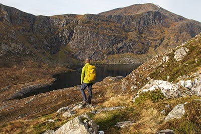
NH2734380068 The craggy southwest flank of Cona' Mheall rises above; you're aiming to climb a line towards the south end of the face. Cross the burn, then ascend to a rocky shoulder overlooking Coire Ghranda, the huge and impressive corrie between the day's two Munros.
© Dan Bailey - UKHillwalking.com, Nov 2021
4
NH2754880351 The ascent onto Cona' Mheall's south ridge needs competent route finding on complex, craggy ground, though most of the scrambling can be avoided. As the ground steepens cut up rightwards, then slant back left on heather between the outcrops. Go up to a point overlooking the head of a grassy gully, then zigzag up through rocks to reach the crest of the ridge.
5
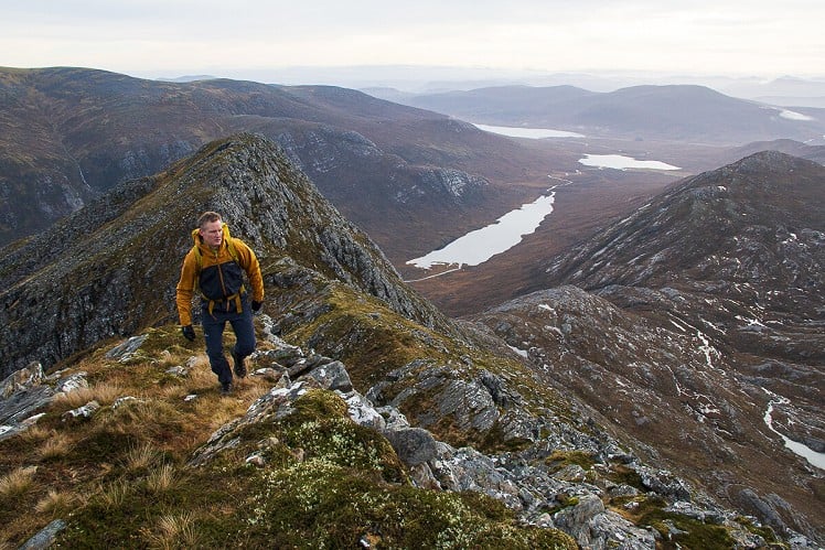
NH2765380597 With some light scrambling, and an airy feel, this is a fantastic ridge walk in a wild setting. Follow the crest onto a minor summit, then make a short steep downclimb to a little saddle. With occasional light scrambling, follow the stepped upper ridge onto Cona' Mheall's stony summit plateau. Follow the edge north-northeast for about 500m to reach the top.
6
NH2749881640 For the least stony descent, backtrack a little southwest to pick up an intermittent path before heading west and then northwest down to the low point of the complex bealach between Cona' Mheall and Beinn Dearg. Now on a well-trodden path, make a rising traverse across the south side of a rocky minor summit (pt. 884m) to reach a lochan on the higher col beyond. Here you'll meet the famous Beinn Dearg wall. This was built by starving crofters during the potato famine of the 1840s, a time when it was felt charity had to be earned through hard labour. The path follows the wall up the steep northeast spur of Beinn Dearg. Where the wall kinks west, leave it and go south over the broad slopes of the domed summit (care needed in poor visibility).
7
NH2591281188 Some guides advocate the southeast ridge descent off Beinn Dearg, but the lightly trodden south ridge is less circuitous. Heading south, meet the cliff edge (again, care needed in cloud, particularly if it's corniced). The south ridge is quite steep, but straightforward, with a defined left edge to serve as a handrail in mist. Towards the bottom of the ridge veer slightly right to skirt craggy ground. Continue south down rough slopes to meet the burn draining the mountain's remote southern corrie - a delightful water feature flowing down a long series of clean-washed slabs. Stay on the west bank of the burn, where a vague trail leads steeply downhill back into the glen of the Allt a' Ghabhrain.
© Dan Bailey - UKHillwalking.com, Apr 2011
8
NH2537978906 Re-cross this burn about 1.5km upstream of your earlier crossing. Head roughly south over boggy ground, then make a rising traverse below Meallan Mhurchaidh (you may be lucky enough to find yourself on a path, of sorts). Pass over the low ridge above, to rejoin the stalker's path of stage 1. At long last you're on a clear, well-made trail, and it's a quick and easy descent back to the A835.
This has been viewed 2,902 times
Download
OS maps and some other mapping apps don't allow waypointsStatistics
Difficulty: DifficultDistance: 9.76 miles (15.70 km)
Total ascent: 1,190m
Time: 7 – 8 hours (Walking)
Voting:
from 3 votes
Login as Existing User
to rate this walk.
to rate this walk.
Additional Information
Start/Finish:Car park south off the road, at the west end of Loch Droma near the farm buildings at Lochdrum, NH253755
Nearest town:
Ullapool
Terrain:
The lower ground is invariably boggy, and much of the route pathless. With some brief grade 1 scrambling by the easiest line, and options to make things harder, the steep ascent onto Cona' Mheall's south ridge takes some route finding ability. The ridge above is a delightful airy walk with short hands-on sections. Straightforward hill paths from Cona' Mheall to Beinn Dearg, but the descent of the latter's south ridge puts you back on rough and little-trodden ground. In wet weather the double crossing of the Allt a' Ghabhrain needs care, and at times it may be impassable.
Seasonal variations:
A big walk for brief winter days, but with a bit of navigation the long approach and return would be very do-able in the dark. Cona' Mheall's south ridge is a grade I winter mountaineering route.
Weather and Hill Conditions: mwis: Northwest Highlands – Met Office: West Highlands
Public transport:
The start is on the bus route from Inverness to Ullapool
Guidebooks:
This route gets a brief mention in The Munros (SMC)
Maps:
OS Explorer 436 (1:25,000), OS Landranger 20 (1:50,000) Directory Listings:
Find more Listings near this route Tourist info:
Ullapool (0845 22 55 121)
Further Routes
by Dan Bailey UKH


I’ve always admired the view of the hills from the Glen south of Beinn Dearg. I was working on a peatland restoration project, you probably crossed some of the gully dams on the outward part of the route