


User Comments
You'll have to go back and walk a little further north to Green Hill (628m) https://www.geograph.org.uk/photo/3864264 and just topping Gragareth. If the OS are correct then Green Hill's the highest point in Lancashire (although your head probably was when the missus took the photo).
Lankyman - 16/Sep/18
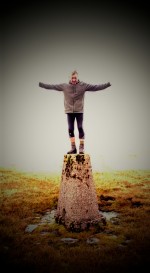
Yes I was hoping for a comment like yours , I have wondered about this, Green hill is 628 mtr's as opposed to Gragareths 627 mtr's . I am aware of the ongoing debate regarding which one of the hills really is Lancashire's highest summit , Now the OS map shows Gragareth clearly lies 200 mtr's in side the Lancashire boundary and Green hill is on the boundary line , so its debatable and you are correct that opinions do differ, so I am going to add a question mark to the photograph , thanks for your comment ..
BigHell - 17/Sep/18
If you look really closely (magnifying glass?) you'll see that the brown 628m spot height is just west of the county boundary/border by about so is within Lancashire. I know the spot height isn't as accurately surveyed as the trig point but until someone gets up there with all the necessary equipment (as they did on Calf Top nearby) you can only go on the figures. Anyway, it's a cracking traverse on towards Great Coum and down into Dent if you can get a car at each end.
Lankyman - 20/Sep/18
We had planned to take in Green Hill last Saturday excepting the weather turned sour so we had to descend back to Ireby . There are forums out there regarding this subject matter with differing views on which hill should boast of being the highest of Lancashire's summits. The OS map shows no Trig Point for Green Hill and strangely the name of the hill is printed on the map starting on the Lancashire side and finishing in the border line with the highest measurement of 628 mtr's printed on the Yorkshire side of the boundary wall where as Gragareth is clearly within the boundary and has a Trig Point. Mrs H cant see what the fuse is about , its certainly not clear . Any way am going to have to take a closer look but not this week as we are off to revisit Trow Gill and take in Ingleborough Cave . Thanks again for your interest.
BigHell - 20/Sep/18
Sorry to harp on but you need to look at the brown SPOT height of 628m (very close to the bottom of the grid square north of the name 'Green Hill'). It's just west of the boundary wall and so very much inside Lancashire. Don't be confused by the grey dots which are part of the county boundary shown by dots and dashes running alongside the wall. Trig columns aren't always on the highest points - plenty of examples of this around.
Lankyman - 26/Sep/18
Yes I can see it now . On closer inspection and having followed your directions I can now see the brown spot that marks the summit point , it is very hard to see . As you point out it is just inside the boundary wall . Any confusion could have been dispensed with had the Ordnance Survey put the height measurement along side the spot mark , instead of which the height measurement its clearly printed inside the Yorkshire boundary. I have to say that even with the naked eye and in the comfort of my home the height mark is not easy to spot , (No pun intended ) But at last I can now acknowledge that Green Hill is the Highest summit in Lancashire , problem is I haven't done it , so we are going to have to go back again . Thanks a lot ! Seriously thank you for your interest and comments and putting to bed a long and often discussed topic .
BigHell - 27/Sep/18
Does the terrain when you're up there support that the trig point on Gragareth and the spot height on Green Hill are actually the highest points of each, otherwise the argument from maps becomes irrelevant; the DoBIH gives Gragareth 628m "small cairn 100m E of trig point", and Green Hill 627.5m with the 10 figure gridref looking like it's on the spot height, also says the county top was transferred from GH to G in 2014. So you'll still have to go back, right hill, wrong place :-)
Michael Hood - 09/Sep/22
Doubt I'll go back but thanks for your comment.
BigHell - 09/Sep/22