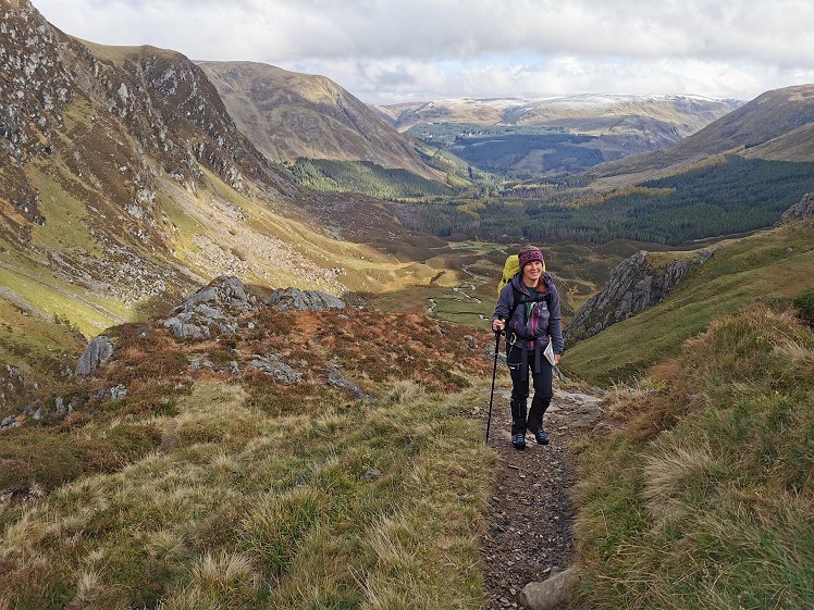
These two Munros are easily accessible from the Glen Doll visitor centre at the tucked-away head of Glen Clova, via the stunning amphitheatre that is the Corrie Fee National Nature Reserve. The standard round is a beautiful and varied walk, taking in some classic post-glacial glen scenery and the wide rolling terrain of the summits. In reasonable conditions it's a comparatively short and untaxing Munro day, but a classic nonetheless.
Fetching Map
Height Profile
metres / Distance
miles
Detailed description
1
NO2835276118 From the car park follow the track with the visitor centre to your right. Keep left at the junction, and go around the locked gate. Keep to the north side of the White Water until the track drops to cross at a bridge. Once you've crossed over via the bridge keep to the main track along the south side of the Fee Burn. Ignore the track on the right that leads to a bridge over the burn, and keep on generally westwards to the end of the track. There is a path that continues out to a magnificent viewpoint as you emerge from the trees into the open reaches of Corrie Fee.
2
NO2535575264 The path continues close to the burn, and is initially flat as it takes you along the floor of the Corrie. The way up the headwall beyond looks steep and uninviting, but stick to the path and you'll find yourself climbing in zigzags, hidden from below, through an amazing array of rocky bluffs and crags adorned with alpine plants. The path involves a little bit of very easy scrambling, but only on very short steps, and any hillwalker should be OK. The path keeps to the south side of the waterfall, and at the top of the steep slope you emerge onto the open hillside at a cairn.
3
NO2412074757 Keep to the path as it initially takes you up into a small upper corrie, then onto broader, more open slopes southwards to the summit of Mayar.
4
NO2409773749 Leaving the summit of Mayar the path is initially indistinct. Go north-eastwards a short way, then eastwards and down to a col at 818m. The path is now more obvious again, and you soon come to fence corner just beyond the col at the top of the Shank of Drumwhallo. Follow the fence along the top of the crags of Black Skellies. Take the path to the right here, down to the col at 809m. Beyond the col the path zigzags up through a short band of scree, and vanishes slightly as you near the flatter ground where there is a cairn on the broad knoll at 915. A line of cairns and old fenceposts leads just north of east to the summit of Driesh with its trig point within a wall shelter.
5
NO2711373582 On the return the more obvious path skirts around the north side of point 915m, and you'll quickly regain the col at 809m. Just above the col on the flank of the Shank of Drumfollow there is a path that cuts across the steep face above Corrie Kilbo to gain the obvious path down the eastern slope of the Shank of Drumfollow. This path drops easily downhill, passing above a small belt of trees before entering the forest lower down the hill. The path takes you over the Burn of Kilbo via a couple of steeping stones, then down again through the clear-felled area of forest to emerge onto a big track. Immediately ahead you'll see a small path. Take this instead of the big track, and you'll pop out lower down the hill, again on the big track having just avoided a zigzag detour. Now follow the big track around a bend and keep on it to a junction. Turn left and go over a bridge. Just beyond the bridge there is another junction. Turn right here and you'll soon be back at the car park.
This has been viewed 959 times
Download
OS maps and some other mapping apps don't allow waypointsStatistics
Difficulty: ModerateDistance: 9 miles (14.50 km)
Total ascent: 875m
Time: 4:30 – 5:30 hours (Walking)
Voting:
from 1 votes
Login as Existing User
to rate this walk.
to rate this walk.
Additional Information
Start/Finish:Glen Doll Visitor Centre car park (£3 for all day parking), NO283761
Nearest town:
Kirriemuir
Terrain:
Forest tracks to start, then a good path leading up into Corrie Fee and onto the open hill above the rim of the Corrie. Beyond that the path is laid in placed, but boggy in short sections too. The path on the descent is stony, but easy enough to walk.
Seasonal variations:
A good route year round, but can be boggy after rain on the broad ridge between the two Munros.
Weather and Hill Conditions: mwis: Cairngorms & Monadhliath – Met Office: East Highlands
Public transport:
None to the start of this route
Guidebooks:
The Munros (SMC)
Maps:
OS Explorer 388 (1:25,000), OS Landranger 44 (1:50,000) Directory Listings:
Find more Listings near this route Tourist info:
Crathie (01339 742 414); Braemar (01339 741 600); Ballater (013397 55306)
Further Routes
by GrahamUney
- Aran Fawddwy - The Highest Mountain in South Snowdonia 11 Oct, 2023
- Hart Fell and Cape Law 7 Jun, 2021
- Murton Pike, Murton Fell, and High Cup Nick 10 May, 2021
- Bampton Fell above the Haweswater Dam 26 Apr, 2021
- The Classic Hartsop Round 13 Apr, 2021


