Rocktype UNKNOWN
Altitude 648m a.s.l
Faces N
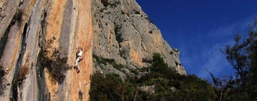
Redpoint of Magic Flute at Bernia on the Costa Blanca (climber Mark Glaister) © Mark Glaister - Assistant Editor
Summit of this hill
This summit has been climbed in 71 logbooks.Hill features
The Bernia Ridge is the spectacular rocky crest that runs from east to west, a short distance south of Calp. It rises to 1126m at the western summit, and has often been described as the Costa Blanca's version of the Skye Ridge. The most impressive section of the ridge has become a beacon for climbers and serious scramblers and provides a fabulous, airy outing. The developed climbing area consists of several sport and trad routes which pick lines out from the good bits of rock along the southern flank of the ridge. The sport routes tend to be in the higher grades and include the classic Magic Flute.The Bernia climbing area faces southwest and get loads of sun, but it is exposed to any wind. Progress along the foot of the cliff can be a painful affair due to the coarse vegetation; the occasional animal track helps. The routes are generally quick-drying. The ridge itself is extremely exposed to any weather that is going and should only be attempted in good conditions.
Approach notes
Climbing Areas - From the N332 coast road at Olla de Altea, take the road inland towards Callosa d'En Sarrià. Go right through Altea Vella, and about 1.5km after leaving the town, turn off to the right (signed 'Serra de Bernia' and 'Fort de Bernia'). Drive up the steep winding road for 5km (quite poor in places) to some small cottages high above the coast. Park here, or at the small picnic area a little further on. To reach the climbs, follow the steep concrete road up to the highest buildings and walk round behind these to locate a good track that cuts across the hillside, descending slightly as it goes. All the routes can be accessed from this path by cutting directly uphill to the base of the routes.The Ridge - Follow the AP-7 to junction 63 and exit here. Turn south and drive through Benissa and turn right at a junction signed for Xalo/Jalon. Immediately take the road on the left signed to the village of Pinos, follow this winding road uphill for around approximately 7km to a left turn that leads to the parking at the start of the approach walk next to a restaurant on the left. From the parking, walk past the front of the restaurant and follow a track/road along the wooded slopes below the ridge to a font at some rocks on the right. From the font, follow a path on the right (yellow and white painted stripes) that climbs up across scrub and scree to meet the rocky base of the ridge at a round hole in the cliff. The hole goes right through the ridge to the other side - a remarkable feature. The path now gets a little steeper and ends in an easy scramble to a col on the ridge and a breathtaking view down to the coast.
Route Cards
|
Summits, Scrambles, and Easy Climbs on this hill
| Name | Grade | Stars | Type | Logs | Partner Ascents |
|---|
These routes you have climbed by seconding or top-roping.
These routes you have Dogged.
These routes you Did not Finish.
Routes are waiting to be checked by a crag moderator, and may not be accurate. Routes can't be verified by a crag moderator, and they need more information to confirm it. Routes are no longer climbable.