Climbs 1
Rocktype Mica schist
Altitude 333m a.s.l
Faces W
Bolting The Steeple Direct © Koon
Crag features
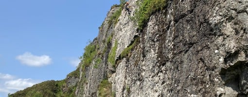
Just West of the summit of The Steeple, a 30m high crag overlooks the village Lochgoilhead. From a rock climber’s point of view, while impressively tall, the cliff suffers from being a bit "ledge-y" and from winter seepage over a lot of its 70m length. That said, the cliff and its satellite buttresses still have potential for some very worthwhile routes. Currently, the crag has only one equipped SPORT climb. Despite the lack of obviously attactive potential trad routes, it seems likely that cliff may have recieved some attention from the local outdoor centre’s staff over the years. If any lines were ever previously established, it seems any records have since been lost. It has been suggested that the local climber's historic "new routes" book for the area around Lochgoilhead was lost in a house fire a number of years back. The 50+ minute uphill approach will likely ensure the crag remains a quiet spot.
Approach notes
1.9km with 330m of ascent, 50-60 minutes.
See approach route diagram in the crag photos.
From Lochgoilhead village car park opposite the post office follow sign posts for the Cowal Way footpath towards Arrochar. A road, then track, past the public toilets and Scouts' outdoor centre, leads up towards the open hill side. 300m from the car park, a forestry road is reached. Cross the forestry road, continue up hill to the left, still on the Cowal Way, for a further 300m with a tree plantation on your left until another good path dog-legs off on the right through rhododendron. Follow this path to Scout crag and continue steeply uphill past Scout crag's abseil point. On reaching a prominent boulder, The Cobbler comes into view and the path begins to drop slightly before rising again. Continue, tending right, on intermittent paths though the grass and heather to the summit of The Steeple. From the summit, descend South for 60m before swinging Northwest to find a path that leads down to the base of the cliff.
Alternatively, from the prominent boulder mentioned above, after the dip and rise again, break off right through the grass and heather, heading towards some small trees. 400m of intermittent sheep trails lead up and around the hillside directly towards the cliff base. Due to the risk of getting lost on this alternative route, it is probably best, on a first visit, to go via the summit route and recky this more direct route on the return journey, when the way will be more obvious.
| There are no comments from visitors to this crag. |
Climbs at this crag
| Name | Grade | Stars | Type | Logs | Partner Ascents |
|---|
These climbs you have climbed by seconding or top-roping.
These climbs you have Dogged.
These climbs you Did not Finish.
Climbs are waiting to be checked by a crag moderator, and may not be accurate. Climbs can't be verified by a crag moderator, and they need more information to confirm it. Climbs are no longer climbable.
Moderators Updates to this page are checked by a UKC volunteer JLS