Rocktype UNKNOWN
Altitude 3238m a.s.l
Faces N
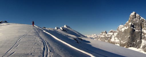
Ski Touring to Grassen opposite the 1000m walls of Titlis © Mike Meysner
Summit of this hill
This summit has been climbed in no logbooks.Hill features
Titlis is a mountain of the Uri Alps (Urner Alpen), located on the border between the cantons (kantons) of Obwalden to the north and Bern to the south.
Uri is also a canton, and is at nearest 1.25km to the south west, on the summit of Grassen, where these three cantons meet. However, only part of the canton Obwalden participates in this tripoint, the greater and founding part resides to the west in the valley of the Alpnachersee, Sarnersee and Lungerersee (this valley, which seems to be curiously unnamed, or might just be the "Obwalden" valley, may be more familiar to readers as the passage from Lucerne (Luzern) to the Brunig pass). The canton of Nidwalden, and the aligned Engelbergertal, separates the two parts.
Delving deeper into this mystery, Obwalden and Nidwalden were initially the two parts of the canton Unterwalden, forming together in 1315 with Uri and Schwyz (which is to the north east) the Old Swiss Confederacy: the precursor of todays CH, Confederation Helvetica, Switzerland. Meanwhile, the Scots and English continued to war, one year after Bannockburn. The organisation of Unterwalden varied over the years, notably in the short-lived Helvetic Republic of 1798-1803. This centralization was imposed by the invading French Republic, wrecked by civil war, and dissolved by First Consul and later (1804) Emperor Napoleon Bonaparte in the Act of Mediation. During this period Unterwalden was part of the larger Waldstätten canton which brought the founding "forest" cantons together with canton Zug, the Republic of Gersau (on the north shore of Lake Lucerne) and the Abbey of Engelberg. The reversion to the "natural" state of federation restored Unterwalden, and when the Abbey of Engelberg and district joined Obwalden in 1815, Obwalden became its separate parts. Without dwelling unduly on the intervening years, in 1999 the name Unterwalden was removed from the Swiss constitution and Obwladen and Nidwalden were named as Cantons (although they are often referred to as half cantons due to each having one seat only in the national council instead of the normal two per canton).
At 3,238m above sea level, Titlis is the highest summit of the range north of the Susten Pass, lying between the Bernese Oberland and Central Switzerland. The first recorded ascent from the north "Von Trüebsee über Rotegg" was made in 1744 by I. Hess, J. E. Waser and two "Klosterleute" (monks, even?) from the aforementioned Engelberg Abbey (SAC Clubführer Urner Alpen 3, 1999).
The south and east faces boast big walls up to 1000m in length, home to hard routes, beholden to names as Perrenoud, Remy, Carrigan. Local activists did and continue to add more. The north side remains glaciated (2020 AD) although there is still a 200m high north wall. The westward ridgeline leads, mainly geographically one suspects, over Reissend Nollen to the Wendenstöcke. From the north, cable cars from Engelberg once delivered pre-pandemic tourist hoards to the Klein Titlis summit. Let it not be forgotten, that the area is excellent for off piste skiing and ski touring.
Route Cards
| There are no comments from visitors to this hill. |
Summits, Scrambles, and Easy Climbs on this hill
| Name | Grade | Stars | Type | Logs | Partner Ascents |
|---|
These routes you have climbed by seconding or top-roping.
These routes you have Dogged.
These routes you Did not Finish.
Routes are waiting to be checked by a crag moderator, and may not be accurate. Routes can't be verified by a crag moderator, and they need more information to confirm it. Routes are no longer climbable.