Supported by

Full size version is only available to registered users


Please Register as a New User or Login as Existing User to gain full access to all the photos on this site. Registration is quick and completely free.
Unregistered users can only view full size photos that have been added this month.

thumb
Soviet military map of Muzkol range, Pamir mountains, Tajikistan.
© JdotP
Supported by

User Comments

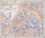
Climbed summits marked. Black datum is Soviet map datum (Pulkovo 1942 I think), red datum is WGS84 datum (used by google earth and most GPSs). Range lies at 38 deg north and 73 deg east, labels for grid lines are in minutes.
JdotP - 18/Oct/13
Actually, there are 3 minor named peaks I forgot about. 4 Nations Peak, Pt Theresa and Pt Marina (F.A. EWP group) are minor points on ridge leading NW from Muzkolski.
JdotP - 28/Oct/13
Login as Existing User to add your comments
This picture is copyright. If you want to reproduce or otherwise re-use it, please email the photographer direct via their user profile. Photo added October 19 2013.
Loading Notifications...