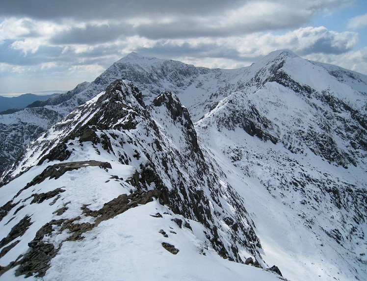
Perhaps it's only fitting that the highest mountain in Wales boasts the country's greatest all-day scrambly ridge traverse. Indeed there's no better route of its kind in the British Isles south of the Scottish border. The walk has a compelling logic, following narrow ridge crests encircling the massif's huge eastern cwm and linking its four principal summits - three of which are three thousanders. Notable scrambling is encountered on the ascent and traverse of Crib Goch and the continuation ridge Crib y Ddysgl, which leads to Snowdon's second highest peak Garnedd Ugain. Though it's not technically difficult (grade 1 by the line of least resistance) this entire section is relatively serious with some surprising exposure and few easy escape options. With its train station, cafe and crowds the summit of Yr Wyddfa itself is a bit of a let down, but the final traverse over sharp-spined y Lliwedd rounds things off in suitably spectacular style.
Detailed description
The scrambly Crib y Ddysgl ridge is now obvious ahead, a stairway of little rock walls and easier walking sections. The first rock step is the main difficulty, best done by staying just left of the steepest rock before regaining the arête, which is then followed in easy but airy fashion over several false tops to the trig point on the second highest peak in Wales.
This has been viewed 70,134 times
Download
OS maps and some other mapping apps don't allow waypointsStatistics
Difficulty: DifficultDistance: 7.10 miles (11.43 km)
Total ascent: 963m
Steepest Gradient: 58% (1 in 2)
Time: 6 hours (Walking)
to rate this walk.
Additional Information
Start/Finish:Pen-y-pass pay and display car park, SH647556
Nearest town:
Llanberis
Terrain:
Ranges from the flagstone-paved Pyg Track and the almost road-like Miner's Track to much steeper and stonier mountain paths, with plenty of exposed grade 1 ridge scrambling. Wet and windy weather can make the crest of Crib Goch feel pretty dicey and bear in mind there are regular accidents here. No bogs - you can leave your gaiters at home.
Seasonal variations:
In full winter conditions this exciting summer walk becomes a genuine mountaineering route. The whole section from Crib Goch's east ridge and along the crest to Garnedd Ugain becomes grade I climbing ground, and though ill prepared walkers often bimble along it unawares it's worth treating this stage with care, particularly if there's deep snow or verglas. Depending on the conditions an ice axe and crampons range from sensible precaution to indispensible, while even a rope might not seem total overkill at times. There's no real challenge on the ascent to Y Wyddfa, but from here the steep descent to Bwlch y Seathau may be icy. Under snow the crest of Y Lliwedd has a mountaineering feel but it's much easier than Crib Goch.
Weather and Hill Conditions: mwis: Snowdonia – Met Office: Snowdonia
Public transport:
The Pen y pass car park is expensive, and rapidly fills up at weekends. Using the Snowdon Sherpa bus it’s possible to park and ride from several points including Nant Peris, Capel Curig, Betws y Coed and Beddgelert www.snowdoniagreenkey.co.uk
Guidebooks:
The Ridges of England, Wales and Ireland, Dan Bailey, pb. Cicerone http://www.cicerone.co.uk/product/detail.cfm/book/539/title/the-ridges-of-england--wales-and-ireland
Maps:
OS Explorer OL17 (1:25,000), OS Explorer OL18 (1:25,000), Harvey/BMC Snowdonia (1:40,000), OS Landranger 115 (1:50,000) Directory Listings:
Find more Listings near this route Tourist info:
Llanberis (01286 870 765); Beddgelert (01766 890615); Blaenau Ffestiniog (01766 830 360)
Further Routes
by Dan Bailey UKH
- East Ridge of Beinn a' Chaorainn and Beinn Teallach 21 Jan
- A' Chralaig and Mullach Fraoch-choire 4 Dec, 2023
- Meall na Teanga & Sron a' Choire Ghairbh - The Loch Lochy Munros 6 Nov, 2023
- Bynack More 19 Oct, 2023
- Beinn a' Mhuinidh 4 Oct, 2023


