Climbs 27
Rocktype Artificial
Altitude 15m a.s.l
D. Shorthouse on a technical section of Python © [email protected]
Crag features
Let’s get two things straight. One, you don’t come here when the local gyms have just reset their routes. Nor, if you have the day off and can drive to the Peak. Reserve this “crag" for when you’re bored with the gyms and don’t have time to travel. In short, you’re desperate. Or, the country is in lockdown…
Second, people have been climbing here, or, at least, chipping holds so they can climb, since the 1970s and possibly earlier. A link below directs you to an ‘80s “guide" to the crag. Unfortunately, this guide does not list the FAs. The routes have no doubt changed since then too. The most obvious change being the coats of paint on some routes, courtesy of local artists. Meanwhile, other routes are now only sent by vines.
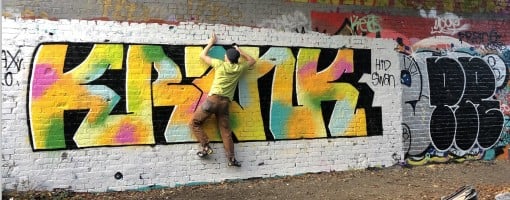
All that said, this crag is a contender for the most colourful in the UK. Locals are concerned that if word gets out then “Instagram climbers” will send property prices through the roof. Ok. That might be an exaggeration. But, everyone takes photos of each other here.
Some describe the area as a bit grim, and for good reasons: the used spray paint cans speak to why you keep slipping off some holds, and the smashed glass makes you curse the artists. A famous author once described the edges of cities as “bastard countryside”. But others see beauty in the “urban wilderness". Maybe, just maybe, as you sit on a log slapping the lactic acid out of your forearms, you’ll catch a glint of sunshine through kaleidoscopic autumn leaves. You’ll never feel like you’re in the Highlands. But you might feel like you left Cambridge for a moment.
In the interests of historical accuracy, the FA of each route is divided into two categories. The first is the original ascensionist (OA). No OAs are listed because we’re unaware of any (please update the website if you can). The second category refers to the “sixth coat of paint” (SCOP). This captures the fact the routes are different compared to when they were originally “chiselled”. In all instances, the original names of the routes are adopted from the ‘80s guide, but the grades have been revised to reflect modern conditions and grading systems.
Contact the moderator for a copy of the '80s guide.
Approach notes
From Fen Ditton, make your way out High Ditch Rd. After about 300m you'll go over a bridge. Then about 100m later you'll see a "national speed limit applies" sign (the one with the diagonal cross over a white background). On the opposite side of the road is 40 mile an hour sign, and right next to this sign is a small track. Walk down this track, following it around to the right. About 100 m farther on you'll see the bridge that you crossed and all the climbs below it.
Alternative approach; not quite as direct but avoids any walking on a narrow road with no pavement. Walk east out of Fen Ditton along High Ditch Road. Before you leave the bounds of the town (about 50m before the traffic calming installation), follow the public footpath sign to turn off right down a short street. Keep following the footpath to quickly branch off left through a gate onto a field, head diagonally across the field, then through another gate and down some steps to join the old railway line. Walk east along this for 200m to reach the bottom of the bridge.
Access Advice
As of 17th March 2024, the bottom of the crag is about 20cm underwater, rendering all routes inaccessible for the time being.
Find Fen Ditton, and then find the Green Man going out of the village, turn right, and after about 200m there is an old railway bridge. The path down is on the far RH side. (details from website above)
|
Climbs at this crag
| Name | Grade | Stars | Type | Logs | Partner Ascents |
|---|
These climbs you have climbed by seconding or top-roping.
These climbs you have Dogged.
These climbs you Did not Finish.
Climbs are waiting to be checked by a crag moderator, and may not be accurate. Climbs can't be verified by a crag moderator, and they need more information to confirm it. Climbs are no longer climbable.
Moderators Updates to this page are checked by UKC volunteers ponsta and SCClimb