


User Comments
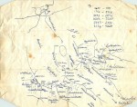
Before modern technology, you copied stuff out of books. This map, as I recall, was copied out of Slingsby's book from 70 years previously. I think someone had copied pages from the library or something.... my memory is hazy as to the exact provenance
pneame - 13/Apr/16
Looks like you used it too! Provided you copied it something like accurately and you got north in the right place you could probably navigate OK with a compass. Assuming it was reasonably accurate in the book, that is.
jon - 13/Apr/16
I like the tea stains.
deepstar - 13/Apr/16
It really felt like exploring - I recall us looking down from our first peak and seeing some footprints on the glacier below us - "whose are those?" "It's none of us" "who could it be?". I'm sure it's heaving with people these days, like everywhere else. There are some great pictures on Google earth
pneame - 13/Apr/16