

It's the high point near where the Welsh-English border runs over the Black Mountains, but there all certainty ended. Should it properly be called Black Mountain or Twyn Llech? And which country could rightfully lay claim to the summit? Following research by two independent surveyors, Myrddyn Phillips assisted by Mark Trengove, the mystery surrounding one of the most visited hills in South Wales has finally been cleared up... with a surprising conclusion.
Mark and I are both keen hill walkers with a common interest in hill bagging and the classification of hills. This particular hill was of interest, as its summit position and the location of the border between England and Wales, in relation to the summit, has been under debate. Was the summit on the Welsh side of the border and therefore could the hill be claimed as being Welsh, or was it in fact English? Our aim was to determine where the summit of the hill is positioned, measure its height and plot the course of the border between Wales and England as it crosses the summit plateau.

© Myrddyn Phillips
The Name
Rising above the Vale of Ewyas on its Welsh side, and the upper Olchon Valley on its English side, the hill is known by many as Black Mountain; however research suggests that it was supplanted by early hill-list compilers from the old ridge name given to the main easterly spur of this hill range, and does not apply to the hill itself. This easterly ridge is now known as the 'Hatterrall Ridge' after its southerly outlier, Hatterrall Hill.
Enquiries with the local farming community unearthed the feature name of 'The thieves' stone'. This name was given by David Gains who farms in the Olchon Valley. David explained: 'It's hanging out on a slope, straight on top of the ridge, just on the Welsh side and about 3-4ft wide'. He first heard of this name from his father, who passed on a saying: 'If a sheep grazed the land around the stone and kept by the thieves' stone it would never get maggots'.
This name still appears on contemporary Ordnance Survey maps in its Welsh form of Llech y Lladron, and is given to a rock outcrop on the upper northerly section of the hill.
This and the name of Twyn Llech are the two main named features on this hill, and it is the latter that many know as this hill's referred to Welsh name, which can be translated as 'hill of the stone (or crag)'. This name still appears on Ordnance Survey maps positioned to the west of its summit. Therefore for the remainder of this article we'll refer to the hill as Twyn Llech.

© Myrddyn Phillips
The Hill
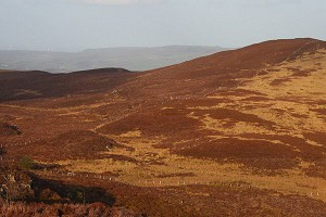
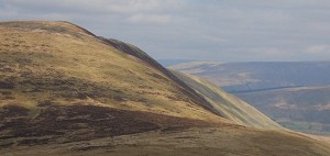
Twyn Llech is positioned in the Black Mountains in the south-eastern part of Wales. This hill range has four main extended ridges oriented in a north-west to south-east direction, and Twyn Llech is the highest point of the most easterly of these main ridges.
The hill comprises grass and heather with a base of peat; it is not dramatic in nature but is a great bulk of a hill. The high point is situated toward the northerly section of the main easterly ridge, which extends for approximately 15km. It has two main recognised and individual summits on it, one of which is Twyn Llech and the second the southerly outlier Hatterrall Hill.
There are two significant marker lines on contemporary Ordnance Survey maps that follow the course of this easterly ridge. One is a public right of way that designates part of the Offa's Dyke long distance footpath, and the other is the land border between Wales and England. These are positioned next to one another on the maps. As the summit of the hill is positioned to the west of the ridge path, it has generally been accepted that it is therefore in Wales.

© Myrddyn Phillips
Research
Prior to visiting the hill I conducted extensive research into the position of the border between Wales and England. My hope was to find a written document that gives detail of the position of this land boundary, and especially for the course that it takes over the main easterly ridge of the Black Mountains.
A number of individuals, public bodies and organisations were contacted including the Powys Archives, Powys County Council, National Library of Wales, Longtown Historical Society, Ewyas Study Group, Hereford Record Office, Brecon History Society, Clwyd Powys Archaeological Trust, Hereford Border Authorities, Electoral Services, Boundary Commission, Ordnance Survey, HMSO, Electoral Commission, local historians and the Senedd. None of them could either supply or give information on any form of written document relating to where the land border between Wales and England is positioned. In fact many said that such a document did not exist. The only organisation that gave any indication as to where this border is positioned was the Ordnance Survey, and they simply instructed me to consult their maps.
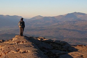
The Summit
The summit area of this hill comprises a broad ridge of grass and heather with a base of peat. It is relatively flat. However, Twyn Llech has a distinguishable rise on the northerly part of this land, and a dip that leads south to another slight rise approximately 350 metres away, with the northerly high point being relatively easy to distinguish and the southerly high point comprising land that slightly undulates.
These two rises roughly match map detail. The Ordnance Survey give a 703m spot height on their contemporary 1:50,000 Landranger and 1:25,000 Explorer maps, positioned in the southerly part of a 700m continuous contour ring at SO 25586 35010. Harvey maps give a 706m spot height on their 1:40,000 Offa's Dyke South map which is positioned in the northerly part of a 705m continuous contour ring.
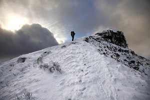
First on-site visit
This concentrated on determining the height and position of the northerly high point and its counterpart to the south. This was conducted during an extended walk I completed, taking in a number of other hills. This also prioritised another hill to the south that was surveyed as having less that 15m of drop and which is currently still listed as a Nuttall. The conditions for each survey were excellent with good visibility and little breeze.
The results of these two surveys are:
Northerly high point: 703.639m (converted to OSGM15) at SO 25520 35383
Southerly high point: 702.721m (converted to OSGM15) at SO 25572 35032
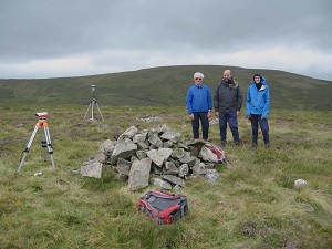
A Trimble GeoXH 6000 GNSS receiver was used to determine the height of Twyn Llech and with a 0.9m difference in height there was confidence that the northerly point is where the summit of Twyn Llech is positioned. As the southerly land undulates a second survey to give correlation and confirmation was sought, and the opportunity to do so came nine months later.
The Border
The second on-site visit gave Mark and I the opportunity to plot the course of the land border on the ground as it passes over the summit plateau of Twyn Llech. To do this we used a Garmin GPS Map 64s hand-held device that has access to the Ordnance Survey 1:50,000 mapping. By following the course of the border we determined that it was consistently positioned to the east of the flagged ridge path, and the path itself is also positioned to the east of the summit of both the northerly and southerly points. Having determined where the border lay according to 1:50,000 map detail, we paced from its position to where the Trimble was set up on the northerly summit and its southerly counterpart, with the former being 50 metres and the latter being 45 metres in distance. Therefore, according to contemporary Ordnance Survey 1:50,000 mapping, the summit of Twyn Llech is in Wales.
However sometimes things aren't as simple as they appear...
The second on-site visit had two aims. Firstly we wanted to determine the position of the land border according to Ordnance Survey 1:50,000 mapping, and secondly to take further data sets with the Trimble GeoXH 6000 from the northerly and southerly positions. The conditions for each survey were again ideal with good visibility and not a breath of breeze. The Trimble was placed on a rucksack, which was used as an improvised tripod to give elevation above its immediate surrounds. Respective measurement offsets were taken between its internal antenna and the ground below.
The results of these three further surveys appear below:
Northerly high point: 703.656m (converted to OSGM15) at SO 25520 35383
Southerly high point: 702.787m (converted to OSGM15) at SO 25558 35018
Southerly high point: 702.699m (converted to OSGM15) at SO 25566 35054
These results show excellent correlation with the first set of survey data and confirm that the northerly point is where the summit of Twyn Llech is positioned.

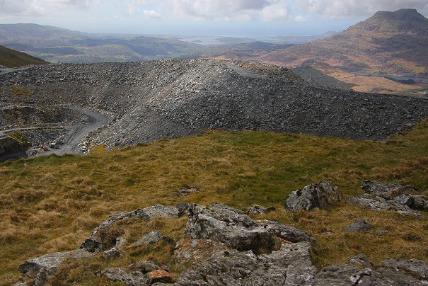
© Ordnance Survey
The Ordnance Survey Base Map
Our on-site visit had confirmed where the summit of Twyn Llech is positioned and had given the hill an accurate height. We now compared our findings to the series of Ordnance Survey Six-Inch maps.
For many years the Ordnance Survey Six-Inch map was considered their base map. This was the map for information to be fed onto. The scale was superseded in the 1950s by the 1:10,000 series of maps and was available as sheets until the 1980s when these maps were digitised. The Six-Inch map is still one of the best for giving detail, either numeric or positional, and it was this map that I turned to.
I consulted the series of Six-Inch maps and looked at detail surveyed in 1887 and published in the same year. The land border between Wales and England appears on this map as a split black line, as it does on the publicly available scales of the 1:50,000 and 1:25,000 maps. However, the line of this border on the Six-inch base map has one extremely important word against it - 'Watershed'. The word 'Watershed' also appears beside this border on the Ordnance Survey Vector Map Local that is hosted on the Geograph website and entitled the Interactive Coverage Map. Therefore this word and its implication have remained in the system of Ordnance Survey mapping for over 130 years.
Ordnance Survey Consultation
As there was discrepancy between our on-site findings using the 1:50,000 mapping and the Six-Inch and Vector Map Local maps the Ordnance Survey were consulted and they kindly forwarded the following information:
"Ordnance Survey is not directed by the Ordnance Survey Act 1841 or any other Act to show National boundaries, although they are shown on certain scales of mapping (1:50k / Landranger, does depict National Boundaries between England-Wales, England-Scotland). In OS's most detailed mapping product OS MasterMap the Welsh / English border is located accurately and correctly it is displayed as a County/UA Boundary.
"OS's 1:25k and 1:50k leisure maps are purely contextual to provide a navigational guide to the landscape. Given their scale, these maps should never be used for measuring and surveying purposes. Our leisure maps are derived from the accurate large-scale data but are generalised for clarity, therefore not every feature is shown in the same position as the source data, and we are satisfied with how they currently depict the location of the Welsh English border."
MasterMap is the Ordnance Survey digitised mapping which receives upwards of 10,000 individual updates per day, and as its name implies, this is the master map for Ordnance Survey data.
I was advised by Ordnance Survey that the placement of the border on MasterMap is 12 metres to the east of the grid coordinates I supplied them for the summit of Twyn Llech, meaning that MasterMap places the summit of this hill in Wales.
Boundary Commission for Wales Consultation
After consultation with Ordnance Survey I was advised to contact the Boundary Commission for Wales. If a change in border placement is required it is this organisation that would initiate it. They told me:
"There is no legal mechanism for reviewing the boundary between England and Wales. The boundary is fixed and would require primary legislation to develop a mechanism to make a change to it. The England-Scotland boundary does have such a mechanism and the review is performed jointly by the English and Scottish Boundary Commissions.
"As far as the Commission is concerned the boundary provided by Ordnance Survey, particularly that in its MasterMap product, is the definitive boundary.
"With regard to the specific area to which you referred, I confirm that it is the convention of this Commission that if we were to draw a boundary that it would follow either the top of a ridge-line to its peak or the bottom of a valley depending on the circumstance; where we are not following another easily identifiable boundary (road, railway line, centre of a river, etc.). It may be that when the boundary was originally drawn at the larger scale that that was the intention. We have no records which would ascertain that intention."
Conclusion
My conclusion from the research and survey I've conducted is that the border should be moved and placed on MasterMap going through the summit of Twyn Llech and that primary legislation should be initiated to instigate the mechanism required for such a change. This is based on the convention the Boundary Commission for Wales would adopt and the evidence that the border followed the watershed on this hills summit plateau on selective Ordnance Survey maps for over 130 years. It is also based on the simple fact that it is the natural course of any boundary on an open mountain such as Twyn Llech to follow the ridge crest which is also the watershed. The simple fact of the matter is that no one had ever surveyed this hill for where its summit is positioned prior to our visit, therefore the border placement on MasterMap although very close to the summit is still 12 metres from it and in all probability was placed to the best of the respective cartographer's presumption of where the watershed is positioned.
So which nation rightly lays claim to the summit of Twyn Llech? I'd say both. If the reinstated course of the border is accepted then it can be considered a dual national hill.


Comments
Is Merddyn making an assumption here: that the highest point of the hill necessarily lies on the watershed? He's established that, so far as can be determined, the Wales/England boundary follows the watershed. However, a hill summit can lie away from its main watershed. As an example, Lochnagar forms the watershed between the upper Dee and Loch Muick. Cac Carn Mor (1145m) lies on that watershed; but the highest point, Cac Carn Beag (1156m), drains entirely into the upper Dee.