

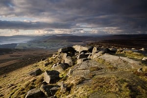
Selected bits of the Peak District have become the first off-road terrain in a British national park to be featured on Google's Street View.
 © Google
We reported back in April this year (see here) that the park was planning to use the Google Trekker backpack to capture detailed 360-degree digital images of remote locations on foot. The technology takes armchair walkers to places the Street View car cannot reach.
Filming was carried out over the summer by national park volunteers.
Here are links to the locations:
North Lees - StanageThe Tissington, Monsal and High Peak trails are now all available online. You can also take a virtual tour along the base of Stanage to check out the routes in close detail. The only thing it can't do is climb them for you.
Jim Dixon, chief executive of the Peak District National Park, said:
'It is our ambition that, by being on Google Street View, more people will enjoy the wonders of this protected and special landscape. Once people see it, I am sure they will be inspired to come and stay for a few days to explore first-hand what they have experienced online.'
'The national park covers an area of 555 square miles so it was impractical to film every inch for people to view. Instead we have selected some of the highlights. These are the trail areas where we offer ranger-led walks, family activities and cycle hire and bike maintenance, so there are lots of ways for people to enjoy and experience what the national park has to offer.'
Whatever your opinion of this leap into virtual walking, and views are bound to be mixed, the level of detail is certainly astonishing.


Comments