
In September 2011 Natural England's Board confirmed that it would be recommending extensions to the Lake District and Yorkshire Dales National Park boundaries that would take in some significant upland areas hitherto falling outside the two parks. The relevant Variation Orders to extend the Park boundaries, maps and boundary descriptions will today be presented to the Secretary of State for Environment, Food and Rural Affairs, and are also available to the public.
The recommendations can be seen until 16 March. There is also a formal opportunity for everyone to provide comments to Defra on the proposals.
David Vose, Natural England's manager for the Lakes to Dales project said;
"After two public consultations and formal agreement by our Board, the proposals to extend the two National Parks will shortly be submitted to the Secretary of State. In the next six weeks, people can send their views to Defra about whether they support the proposals or not, whether there are amendments that they would like to suggest."
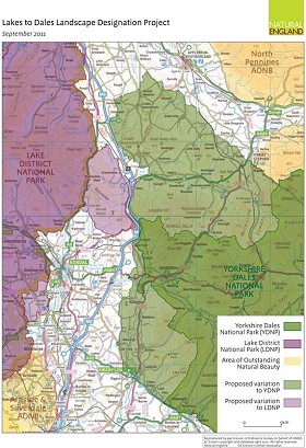
Having considered all the responses, the Secretary of State will decide whether to confirm the Variation Orders or whether to make modifications to the proposed boundaries. Any changes to the National Park boundaries will only take effect once they have received confirmation from the Secretary of State.
In the Yorkshire Dales National Park the recommended changes relate to an area of approximately 418 square kilometres in Cumbria and Lancashire, in and around:
- The northern Howgill Fells, Wild Boar Fell, Mallerstang and part of the Orton Fells (all in Eden District)
- Middleton, Barbon, Casterton and Leck Fells, part of Firbank Fell, part of the Lune Valley and fells to the west (in the Districts of South Lakeland and Lancaster City)
In the Lake District National Park the recommended changes relate to approximately 70 square kilometres of Cumbria, in and around:
- Birkbeck Fells Common, Bretherdale, Borrowdale, Whinfell, Grayrigg and Dillicar Commons and adjacent land (in Eden District and South Lakeland District)
- Helsington Barrows to Sizergh Fell and part of the Lyth Valley and land to the North of Sizergh (in South Lakeland District)
The documents describing these proposals can be viewed online and at 18 locations in and around the project area until 16 March 2012.
Until 16 March 2012 there will be an opportunity for anyone wishing to make an objection or representation to the Orders to send these by email or in writing to: Department for Environment Food and Rural Affairs, Protected Landscapes Team, Zone 1/09, Temple Quay House, 2 The Square, Temple Quay, Bristol BS1 6EB


Comments