

Calf Top. You may not have heard of it, but this unassuming Yorkshire Dales summit has just officially become a mountain. Following a revision of OS modelling, the former hill has nudged over the 2000-foot threshold by an infinitesimal 2mm. One of those responsible is Myrddyn Phillips, an amateur but impressively prolific surveyor who's played a role in the re-measurement and re-classification of summits all over Britain. But when does a mere 'hill' become a fully fledged 'mountain'? We'll leave it to Myrddyn to explain:
The word mountain is very different from that of hill, it's a more robust and altogether larger term. But what does it mean on the ground? In England and Wales, the threshold between mere hills and full mountains has long been considered to be 2,000 feet.

© Myrddyn Phillips
Britain often seems conservative with a small ‘c’; change happens at a slow pace. This mentality is noticeable in our stubborn penchant for imperial height. Where our mainland European cousins abandoned themselves to metrification centuries ago, we in Britain have only slowly followed suit. Metrification has been noticeable on maps since the late 1970s – early 1980s when Ordnance Survey dispensed with imperial height in favour of metric measurement. This may have rather undermined that all important limit of 2,000ft as a signifier for mountain status, but as in Scotland where those 3,000ft ‘hills’ classified as Munros remain ever popular, in England and Wales the listings of ‘mountains’ at or over 2,000ft still have great appeal. These benchmark imperial heights are easily converted to slightly less compelling metric measurements, and the figure of 609.6m (2,000ft) will become all important in this article.
With a benchmark height of 2,000ft (609.6m) established as a line between mountains and hills, it is worthwhile looking at the recent changes to this categorisation, and for the purposes of this article those changes will concentrate on those re-classifications based on accurate surveying conducted by precision levelling and GPS receiver.

© Myrddyn Phillips
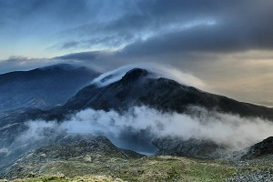
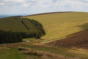
There have been only three such re-classifications to date, all for hills that have increased by known height after accurate surveying. The first of these re-classifications was Mynydd Graig Goch which is situated in Eryri / Snowdonia at the westerly tip of the stunning Crib Nantlle / the Nantlle Ridge. The second was Thack Moor, which is a typical Pennine hill of moorland overlooked by expansive openness and big skies.
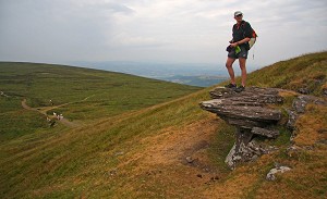
And now we have Calf Top, a grassy summit in the Yorkshire Dales which has grown following a change in the modelling that the Ordnance Survey use to determine heights across the UK.
Mynydd Graig Goch
Old map height 609m, accurately surveyed as 609.78m, seven inches over 2000ft.
Mynydd Graig Goch (SH 49729 48515) was surveyed on 11th August 2008 by Leica Geosystems in collaboration with a group comprising eight people with James Whitworth as surveyor and the makings of who would later comprise the fledgling G&J Surveys; John Barnard, Graham Jackson and myself also being present.
The day of the survey when Mynydd Graig Goch shot up from its 609m map height to the dizzying realms of 609.75m was a particularly wet occasion, so much so that the minimum of two hours of data required for Ordnance Survey verification of the result proved a horrendous affair when shivering was the natural way to try and keep warm!
The news that Mynydd Graig Goch had been declared a mountain was announced on the national news on the BBC and ITN and in a plethora of news radio programmes and newspapers as far afield as Asia and South America. It seemed that news of something increasing by an all-important 6 inches in height tickled the fancy. For the hill walking world it meant that those attempting to complete the 2,000ft’s of Wales had another mountain to visit. I was present on the survey and got particularly cold whilst waiting for the two hours of data to be gathered, I also visited Mynydd Graig Goch with a friend the following day and smiled at the throng of people on the summit, some of whom had seen the story on the ten o’clock news the previous evening and had sped to this rather unassuming part of Wales from all manner of directions in Britain.

© Myrddyn Phillips
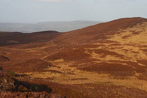
Thack Moor
Old map height 609m, accurately surveyed as 609.65m, two inches over 2000ft.
The second hill that shot up to mountain status after being accurately surveyed by precision GPS was Thack Moor (NY 61166 46277).
This mass of quiet moor is situated on the western extremity of the northern Pennines, its summit lying about 3.5km north-east from the hamlet of Renwick. With a 609m map height it was a prime candidate to survey. However this hill (mountain) has a triangulation pillar placed on a part of its summit area. These pillars formed a part of the Ordnance Survey's triangulation of Britain with the majority having flush brackets adjoined to their sides where the height was taken to. These flush brackets are usually placed 30-35cm above the natural ground at the base of the pillar. All known flush bracket heights have been catalogued and later turned into an online database named rather fetchingly as the ‘OS Trig Database’. Most trig pillars were given a class of ‘order’ representing the accuracy given their height, and in the case of Thack Moor the height given to the flush bracket is 609.60m and the order of accuracy is given as 2. Therefore, if the flush bracket height was accurate and if the trig pillar was positioned at the high point of Thack Moor it meant that ground at its base would be approximately 609.30m high, 30cm below the benchmark height of 609.6m (2,000ft). We decided to go up anyway, spent a long time surveying it accurately, and found the high point to be on the opposite side of a stone wall from the trig pillar. Once we'd packed up and descended, and the data were processed we stood back in amazement as the figure of 609.645m popped up on the computer screen; 4.5cm over that all important benchmark height!

© Myrddyn Phillips
Such a close result needed verification by Ordnance Survey and they advised us to revisit the hill and get a further four hour data set. There were still patches of snow on the higher ground and we had to scrape a large amount from the ground on the north-eastern side of the summit ridge wall, before checking with the level and staff where the high point lay. This process pinpointed the summit and the Leica GS15 was positioned over it and four hours later, after the all-important data were safely stored, we packed the equipment away and descended back to the friendlier climes of the valley below. Once home the data were processed and then sent to Ordnance Survey who used Bernese software to check the accumulated six hours of data, they declared that Thack Moor was indeed over 2,000ft high with a height of 609.62m, a mere 2cm over 2,000ft.
The news of Thack Moor being a new mountain again entertained a number of news outlets - not least UKHillwalking (see here).
Hills becoming mountains is obviously a popular story, with an easy soundbite. However it is also based on science and cutting edge technology, and the determination of some to visit the finer places Britain has to offer and hunker down for a number of hours when Britain’s fickle weather throws all forms of horrendous elemental forces at them.
Calf Top
Old map height 609m, accurately surveyed as 609.002m, no more than a smidgeon over 2000ft.

© Myrddyn Phillips
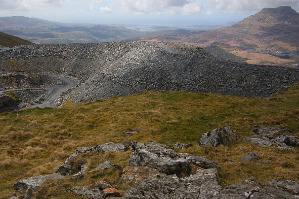
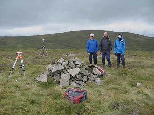
The third in this tripartite of accurately surveyed newsworthy height orientated novelties is Calf Top (SD 66450 85626).
This hill is another that was given the map height of 609m; and as with Thack Moor it is also another hill that had a triangulation pillar placed on the area of its summit. Calf Top is situated in the north-western part of the Yorkshire Dales and rises above the valleys of Barbondale to its south-east and Dentdale and the River Dee to its north-east. It is another fine hill, one of those steep sided grass laden hills that seem to epitomise parts of England. It is rather eloquent in shape with steep eastern slopes descending to the minor road beside the Barkin Beck, whilst its south-westerly slopes descend toward the village of Barbon. Calf Top is separated from its higher neighbourly peaks of Gragareth and Great Coum by a deep cleft named Barbondale; this natural deep trench means that Calf Top, although not the highest hill in the area is one of the most prominent.
However, although the qualification of prominence is an important factor when differentiating a bump from a hill from a mountain, with the continuing appeal of the Marilyns being evidence of this, it is the height of Calf Top and not necessarily its prominence that is of interest. Its accurately surveyed height has recently increased in known value, not by much in the grand scheme of things, but nevertheless by sufficient to re-classify it to the dizzying heights of just over 609.6m. For the imperial minded this takes the hill to the benchmark height of being a 2,000ft mountain.
This hill, or shall we now call it mountain, was first surveyed by precision GPS on the 15th April 2010 when two hours of data were collected. The high point of Calf Top was found to be on the opposite side of a partly collapsed ridge wall from where the 609.60m flush bracket is on the triangulation pillar. Once all data were post processed they were sent to Ordnance Survey who again recommended that a four hour data set should be gathered. Armed with an unusual appetite for such things; John Barnard, Graham Jackson and myself headed north to the confines of Barbondale and ascended the hill with all necessary surveying equipment packed in bulging rucksacks. The proceeding second survey of Calf Top was conducted on the 20th May 2010.

© Myrddyn Phillips
The task of weight carried compared to height gained was transient when compared to the enjoyment of being on the hill. However, the task on occasion can take its toll and the second survey of Calf Top proved a hot muggy grind of an ascent where wisps of mist played upon the landscape. Our stay on top of the summit proved a long one as we repeated the levelling process to ascertain the high point which not surprisingly matched that previously found, the equipment was then positioned over the summit and proceeded to gather the all-important four hours of data.
Each data set were sent to Ordnance Survey who processed the data via Bernese software, with the result being a tantalizingly 609.58m height, which is just 2cm, or for those imperial minded enthusiasts a mere ¾ of an inch under 2,000ft. Resigned that such a result cannot be argued with and satisfied that we had done as much as we could, the survey report for Calf Top with what we thought remained as a hill was written, and the classification of Calf Top as a Dewey remained.
However, six years after the two surveys of Calf Top were completed the Ordnance Survey released their new geoid model for the whole of Britain. All accurately surveyed heights in Britain are dependent upon Ordnance Survey base stations, whose height and position are known extremely accurately. They are also dependent upon the geoid model that Ordnance Survey use to ascertain these heights, and this geoid model has just been updated, this is known as OSGM15.
Using OSGM15 takes in the latest transformations that incorporate new gravity data and iron-out any discrepancies. OSGM15 has meant that the majority of heights that have been produced by precision GPS equipment will alter, not by a great amount, but in certain cases like Calf Top, by an amount that makes all the difference.
The following analysis was produced by Alan Dawson, who is a list author and surveyor of note and repute:
Areas most affected are in the main in Scotland with Lewis (up by 20-30cm), Barra (down by 20-30cm), Trotternish and Applecross (down by 10-20cm). East Mull and part of Argyll (down by 5-15cm), and the Scilly Isles (down by up to 35cm).
The affect that OSGM15 has had on accurately surveyed heights in both England and Wales is not as great as in certain parts of Scotland, with the majority of heights that have been produced by precision GPS equipment going up by 2-4cm.
This 2-4cm total is all important as it increases the known height for Calf Top, as well as for those of Mynydd Graig Goch and Thack Moor.
The new height for Calf Top produced by Ordnance Survey using OSGM15 is 609.602m. This is 2mm over the threshold height of 609.6m / 2,000ft. Small margins can sometimes make all the difference.
The new height of 609.602m is so new that acceptance by some of the respective hill list authors whose listings this new height affects, still waits. For those enthusiastic peak baggers these listings are:
- Calf Top is currently listed as a ‘Dewey’ (hills in England, Wales and the Isle of Man at or above 500m and below 609.6m in height – Michael Dewey, published by Constable in 1995).
- One of the listings that Calf Top can be promoted to is; ‘Nuttalls’ (mountains in England and Wales at or above 609.6m / 2,000ft in height with 15m minimum drop. The Mountains of England and Wales volume 2 England – John and Anne Nuttall, first edition published by Cicerone Press in 1990).
- Calf Top can also be promoted to the ‘Hewitts’ (mountains in England at or above 609.6m / 2,000ft in height with 30m minimum drop. The Hewitts and Marilyns of England – Alan Dawson, published by TACit Tables in 1997. The word Hewitt is an acronym for ‘Hill in England, Wales or Ireland over Two Thousand feet high’).
As the height produced by Ordnance Survey in 2010 from data sent them by G&J Surveys came to 609.58m, maps were then updated from the 609m spot height of the day to a rounded figure of 610m. This rounded figure will now remain as although the conversion necessitated by OSGM15 increases the known height of Calf Top, its map value had already been updated, and for those confused souls who walked up Calf Top thinking that they were visiting a 610m high mountain but only reached the top of a 609.58m high hill, they can reclaim their senses in the knowledge that their efforts weren’t in vain.
Myrddyn would like to thank the Ordnance Survey for their advice and support and especially Mark Greaves who processed the all-important data, and John and Graham for the good times.
UKH Articles and Gear Reviews by Myrddyn Phillips
- Completing the Welsh Highlands - Uchafion Cymru 2 Jan
- FEATURE: Penlan - In Search of Deep Country 30 Jan, 2023
- The Huws - 100 great Welsh hills under 2000ft 1 Mar, 2021
- Ups and Downs – The Story of Handbook of the Scottish Hills 18 Jun, 2020
- SKILLS: Welsh (Cymraeg) for Hillwalkers 20 May, 2019
- Compiling the Welsh P15s - the Ultimate Tick List? 10 May, 2019
- Moving Mountain Summits 24 Aug, 2018
- Bagging the Welsh P30s - An Epic Hill List 29 May, 2017
- Going Nuts for Nuttalls - the 2000ft Peaks of England & Wales 25 Nov, 2016
- Exclusive: Meall Gaineimh - A New Munro Top? 8 Jun, 2015


Comments