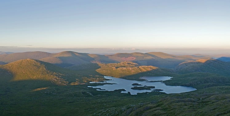
At first glance Galloway Forest Park's go-to would be the reasonably big hills around its edges: the classic high ridgeline of the Rhinns of Kells; the slightly lower but refreshingly rugged Minnigaffs; and the Range of the Awful Hand culminating in the Merrick. But actually, the bit that matters is hidden in the middle. That's where you'll find the grey granite slabs and boulders, black peaty bog, person-eating tussocks and two dozen silvery lochans. The highest, gnarliest of the lochs, and one of the UK's remoter stretches of water, is the amoeboid Loch Enoch, right at the heart of the range. A bog-free little ridgeline with a small path leads up to it; a rather harsher path takes in two more of the lochs on the way down again. So stuff your summits: this is the genuine granity Galloway.
Detailed description
This has been viewed 1,590 times
Download
OS maps and some other mapping apps don't allow waypointsStatistics
Difficulty: ModerateDistance: 7.39 miles (11.90 km)
Total ascent: 484m
Time: 5 – 6 hours (Walking)
to rate this walk.
Additional Information
Start/Finish:Bruce's Stone, Loch Trool, NX415805
Nearest town:
Newton Stewart
Terrain:
Rough grassland and gentle scrambling onto Buchan Hill, then small peaty paths.
Seasonal variations:
Rough grassland is at its roughest August and September. In winter Buchan Burn is likely to be in spate, see route notes.
Weather and Hill Conditions: mwis: Southern Uplands
Public transport:
Nearest is occasional school bus to Glentrool village
Guidebooks:
'Walking the Galloway Hills' by Ronald Turnbull (Cicerone 2019)
Maps:
OS Explorer 318 (1:25,000), OS Explorer 319 (1:25,000), OS Landranger 77 (1:50,000) Directory Listings:
Find more Listings near this route Tourist info:
Newton Stewart (01671 402 431)
Further Routes
by Ronald Turnbull
- The Cheviot: Border Ridge and Hen Hole biggie 14 Feb, 2023
- Windy Gyle from Coquetdale 17 Jan, 2023
- Minnigaffs from Loch Trool 10 Nov, 2022


