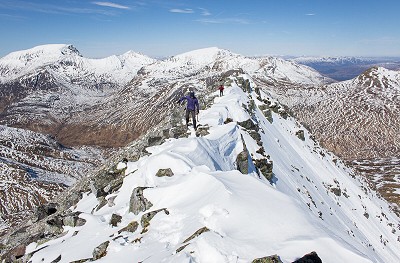
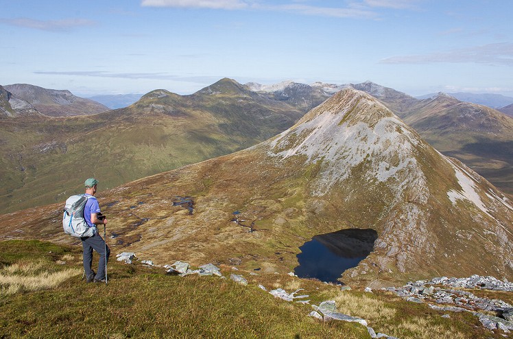
The high crests and chiselled peaks of the Mamores offer some of Scotland's finest ridge walks. The four eastern Munros of the range can be climbed together in a logical circuit from Kinlochleven. Awkward stand-alone summits that mostly seem to be made of scree, the outliers Binnein Beag and Sgurr Eilde Mor do represent a bit of a faff, but their remote feel makes up for the hard grind. With these in the bag, there's the option of a pleasant ridge scramble en route to summit of Beinnein Mor, the dramatic high point of the main Mamores crest, and the stand-out peak for both scale and quality. The sharp twin peaks of Na Gruagaichean round off this classic big day out.
Fetching Map
Height Profile
metres / Distance
miles
Detailed description
1
NN1877762262 From the car park beside a small church in Kinlochmore (the north half of Kinlochleven) head north out of town on a woodland path. Where this splits stay right (the left branch heads to the Grey Mare's Tail waterfall), then cross a small burn before climbing onto an open grassy shoulder with views along the length of Loch Leven. The path eventually meets a 4WD track. It resumes beyond this track, a little way to the left. The old stalker's path now climbs over a boggy slope to enter Coire nan Laogh. Cross a burn, then make a steep rising traverse around the southern foot of Sgorr Eilde Beag.
2
NN2224365095 Having entered Coire an Lochain (more a col than a corrie), leave the main path and head east across the floor of the col to reach the outflow of the main lochan. This is an idyllic spot, popular with wild campers. A rough scree path now climbs the broad southern flank of Sgurr Eilde Mor. Standing at a remove from the main Mamores ridge, the summit is a brilliant viewpoint.
© Dan Bailey - UKHillwalking.com, Sep 2020
3
NN2304765798 To descend head west on a short well-defined ridge, then follow a path that drops right to make a steep and eroded zigzagging descent of the mountain's northwest flank. Near the foot of the hill cut off right to descend grassy slopes, passing the northernmost of the scatter of lochans on the col to regain the stalker's path of stage one. This zigzags downhill to cross the Allt Coire a' Bhinnein, then traverses in a fine position across the middle slopes of Binnein Mor to reach a lochan on the col between the steep bulk of Binnein Mor and the little scree cone of Binnein Beag. Leaving the stalker's path, head northeast along a rocky rib beside the lochan, then follow the scrappy path up steep scree and boulders to the summit of Binnein Beag.
4
NN2216967710 Return to the lochan, then climb very steep pathless ground to gain the northeast ridge of Binnein Mor. Beyond a broad level section the upper ridge is steep and narrow, offering some enjoyable scrambling with options to make things harder or easier (min grade 1). Having climbed onto the sharp summit crest of Binnein Mor, head south to reach the true top. In winter conditions, or if you don't fancy the scramble, the mountain's north ridge offers a more straightforward alternative.
© Dan Bailey - UKHillwalking.com, Mar 2017
5
NN2121266346 Follow the rocky ridge south onto summit 1062m. Here turn southwest, where the ridge descends into a col, before becoming quite ragged as it leads on up to Na Gruagaichean; a path stays just left of the crest to avoid all scrambling. From the airy main peak carefully drop northwest into a little notch before climbing quite abruptly to the second grassier summit. A long descent on a well-scuffed path leads to a low bealach.
6
NN1939565602 Here look out on the left for an old stalker's path that descends south, marked by a cairn. Like your favourite eccentric old relative, this path meanders all over the place without getting to the point in a hurry. But persevere – it eventually straightens out; shortcutting the upper slope would be steep. Head west through a boggy area to reach the Allt Coire a' Bhodaich, which is followed south for about 1km. Briefly turn left onto the 4WD track of stage one, being careful not to miss a path on the right, often masked by bracken. This descends towards Kinlochleven. Bear left at a junction, dropping steeply into the woods to meet the Grey Mare's Tail path. The waterfall is only a quick detour, and worth a look in passing; the car park is just a few minutes further.
This has been viewed 4,556 times
Download
OS maps and some other mapping apps don't allow waypointsStatistics
Difficulty: SevereDistance: 12.18 miles (19.60 km)
Total ascent: 1,844m
Time: 7 – 8 hours (Walking)
Voting:
from 2 votes
Login as Existing User
to rate this walk.
to rate this walk.
Additional Information
Start/Finish:Car park in Kinlochleven, on Wade's Road - as for the Grey Mare's Tail, NN187623
Nearest town:
Kinlochleven
Terrain:
Access around the remote eastern end of the Mamores is made easy thanks to a fantastic old stalker's path (they don't make them like they used to). Steep scree in ascent and descent on Sgurr Eilde Mor and Binnein Beag; then an enjoyable grade 1 scramble (with harder options) up the steep northeast ridge of Binnein Mor. Airy ridge striding from here to Na Gruagaichean, followed by a long but relatively straightforward descent.
Seasonal variations:
An extremely long and taxing route for a brief winter day, so expect to start and finish in the dark. In snow the northeast ridge of Binnein Mor would be an exciting grade I/II winter climb, while the traverse of Binnein Mor's short sharp summit ridge also needs care. Look out on Na Gruagichean too, it's steep and exposed.
Weather and Hill Conditions: mwis: Northwest Highlands – Met Office: West Highlands
Public transport:
Bus to Kinlochleven.
Maps:
OS Explorer 384 (1:25,000), OS Explorer 392 (1:25,000), Harvey/BMC Ben Nevis (1:40,000), OS Landranger 41 (1:50,000) Directory Listings:
Find more Listings near this route Tourist info:
Ballachulish (08452 255 121); Fort William (0845 22 55 121); Spean Bridge (0845 22 55 121)
Further Routes
by Dan Bailey UKH
- East Ridge of Beinn a' Chaorainn and Beinn Teallach 21 Jan
- A' Chralaig and Mullach Fraoch-choire 4 Dec, 2023
- Meall na Teanga & Sron a' Choire Ghairbh - The Loch Lochy Munros 6 Nov, 2023
- Bynack More 19 Oct, 2023
- Beinn a' Mhuinidh 4 Oct, 2023


