Bishop Wilton Wold: County Top of the East Riding of Yorkshire Walking

Bishop Wilton Wold, sometimes called Garrowby Hill, is the summit of the Yorkshire Wolds and is both a Marilyn and a County Top (of the East Riding of Yorkshire). Although the actual highest point is by a main road, and unattractive, the rest of this walk is a fine introduction to the region. It seems odd to find all the characteristics of chalk downland so far north in England, but they are here: extensive rolling green views, dry valleys, and white scars where the underlying rock breaks through. This is a relatively easy circular walk which works well in either direction.

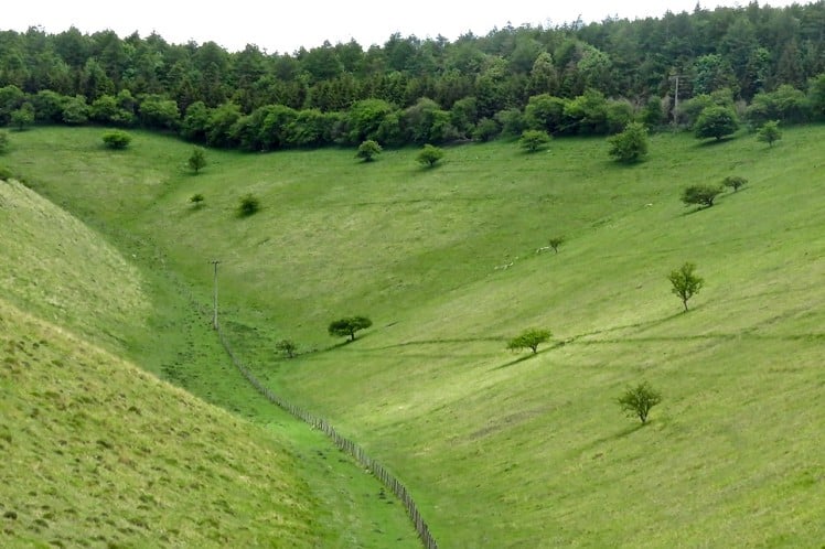
The perfect dry chalk valley, at the head of Deep Dale near the summit of Bishop Wilton Wold.   © Drew Whitworth
The perfect dry chalk valley, at the head of Deep Dale near the summit of Bishop Wilton Wold.
Fetching Map

Detailed description

1
SE7970155087 The walk starts at the bus stop near the Fleece Inn. Start by heading up the right-hand side of Main Street, which spreads to each side of the little stream.

2
SE7999855232 Where the road bends sharp left, turn right, up what looks at first like the drive of a house.

3
SE8078155192 Stay on this path as it climbs the escarpment and loops around the rim of the dry valley below.

4
SE8077455594 Keep following the footpath signs and maintain the height of land.

5
SE8070155831 Stay on the path as it begins to follow the narrow road below, onto which it eventually drops.

6
SE8080056468 Once the path reaches tarmac, turn right and follow the lane to the junction with the A166. Cross with care and go straight on.

7
SE8089356960 Here, the public footpath is marked on the map and by a signpost as heading right, through the gate, but this is locked. It is worth negotiating it to save a few hundred yards of road walking.

8
SE8164156890 Where the path comes out onto the road again, there is free access. Turn left: there is a wide verge then a pavement on the south side of the carriageway. Look for the roadside memorial to victims of an air crash in 1944.

9
SE8208156954 The trig point on the summit is placed behind the fences that bar access to the covered reservoirs and is inaccessible, but that doesn't really matter as the true summit is in fact the copse of trees in the next field, marked on the OS map as a 'tumulus'.

10
SE8234756930 Past the summit, turn right down a long, straight road known as 'The Bence'.

11
SE8281255944 After a few hundred yards, bring the road walking to an end by turning right down a signposted path.

12
SE8224855518 The path drops into Deep Dale, a classic dry chalk valley. This will be a stiff climb if doing the walk in a counter-clockwise direction.

13
SE8206655611 At the bottom, go through the gate and turn left to follow the dry valley down.

14
SE8209055151 Keep following the valley down.

15
SE8252354399 At the sight of the first open water of the walk, look to cross the stream on a footbridge and begin following the opposite (right-hand) side of the valley.

16
SE8220853484 When the path goes through a gate and emerges onto a white, stony lane, turn right.

17
SE8141053838 Inspect the minuscule and secluded church of St. Ethelburga's, then come out onto the lane and cross straight over.

18
SE8097753841 At the end of the few large houses that constitute the village of Great Givendale, turn right, signposted as the "Minster Way".

19
SE8069254527 Keep following the Minster Way signs as the route drops down across a colourful common.

20
SE7993554731 At the bottom of the path, turn right along Pocklington Lane.

21
SE7971855072 The route ends at the Fleece Inn. The bus stop is just outside.

This has been viewed 11,774 times


Further Routes

by Drew Whitworth


Loading Notifications...
Facebook Twitter Copy Email