Pennine Bridleway - Settle to Kirkby Stephen Mountain biking

This ride is a great day out. It crosses the Yorkshire Dales from south to north, then hitches a ride on the Carlisle - Settle railway to return.
The Pennine Bridleway now stretches almost uninterrupted between the Peak District and Cumbria. The northern section, which involves miles of brand new or improved bridleway, has been in place for some time, but only officially open since June 2012. As such, it still does not appear in full on OS maps. However, it's certainly ready to ride, and a fantastic day out, passing some of the best scenery the Dales has to offer. This route follows the majority of the northern section, with two notable exceptions - it misses out a short loop taking in Feizor and Long Lane near Clapham, and heads straight for Kirkby Stephen rather than including a final climb over the back of Wild Boar Fell. Both of these are worthwhile alternatives, though they add extra mileage and climbing to the total. Even hardier souls may also wish to include the brilliant Settle Loop at the start, although this knocks the total past the 50 mile mark and adds a significant amount of ascent.

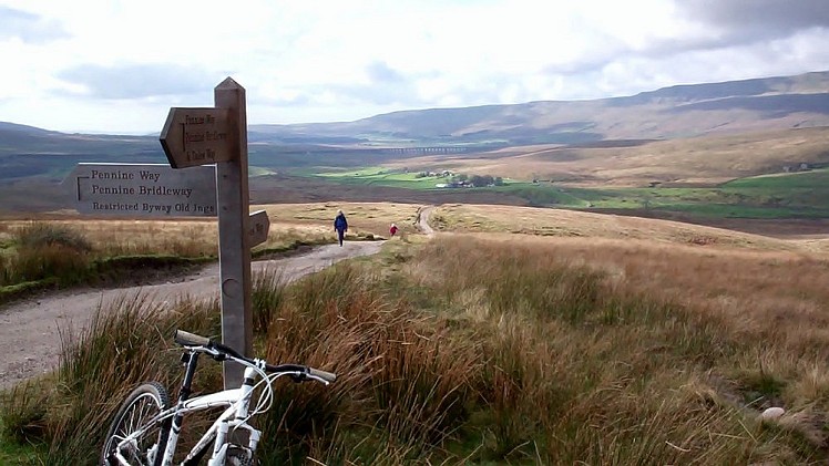
At Cam End, looking out to Ribblehead Viaduct and Whernside.  © MHutch
At Cam End, looking out to Ribblehead Viaduct and Whernside.
Fetching Map

Detailed description

1
SD8178563353 From the centre of Settle, follow roads to the market place (All the usual shops as well as 3 Peaks Cycles are here). From the north-east side of this, follow Constitution Hill steeply until an even steeper track, marked 'Pennine Bridleway - Langcliffe' forks off RW. This eventually turns into a more moderate climb through fields and gates, emerging on a minor road after approximately 1.5 miles. Those 'warming up' on the Settle Loop rejoin here, climbing the minor road briefly until a marked tarmac track heads left and down. This is followed to Upper Winskill Farm, where it turns right and crosses fields to pick up another track offering a fun descent into Stainforth. Go through the village to meet the main Horton-in-Ribblesdale road. The easiest option is to turn right then almost immediately left onto a minor road to Little Stainforth.

2
SD8144067182 After climbing back away from the Ribble and passing a camping site on the L, turn right onto another minor road and follow this for 1.5 miles, where it joins the road between Austwick and Helwith Bridge. Heading L, after a few hundred yards the official Pennine Bridleway heads off LW up the hill over to Feizor. There is a tea room in Feizor... However, this route follows the road a little further before taking a bridleway up through the beautiful off-road hamlet of Wharfe. After twisting through the houses, it starts climbing pleasantly up singletrack before descending to a pretty ford with a stone clapper bridge. Show-offs will ride this, before heading up the track to a t-junction.

3
SD7716170651 Turn right and follow the good track until it turns away into a farm. The bridleway goes straight on onto grass at this point, through a gate, proceeding to a signposted bridleway turning steeply up the grass hillside. Follow this, parallel with the wall on your right, until it turns underneath Long Scar and heads towards Sulber with views out across the brilliant limestone scenery to Ingleborough and PenyGhent. Crossing the main Ingleborough/Horton path, it continues down fun grass bridleway towards the farm at Borrins, and onwards to meet the Horton Road again just south of Selside (there is a tea-room advertised at Selside, but it's worth checking in advance if this is an important part of your rehydration strategy. A more reliable option is the cafe at Horton. The station is also close by if you've already had enough).

4
SD7879474638 The next section starts directly opposite the track from Borrins. However, it's a good, new track which briefly follows the road before dropping to pass under the railway, then continuing to a brand new and rather attractive bridge across the Ribble. None of this is currently (06/12) on your OS map! After crossing, follow the track to a barn then sharply uphill to meet a minor road.

5
SD8020975955 Head L on the road, passing farm buildings, until a gate leads to a good track, with Pennine Bridleway signs. Now you start the climb up to Cam High Road. At another gate, ignore the BW heading west to Beckermonds, continuing north. All this is signed, so should be no bother. Eventually you meet the Dales Way at Cam End, turn right and continue to climb until eventually you meet tarmac. A short distance further, a sign takes you through a gate and onto a brand new bridleway heading at first SW and then NW down to Newby Head. A large section of this is nice firm smooth singletrack with swooping corners and even a few opportunities to get both wheels off the ground. You'll fly out onto the Ingleton-Hawes road, which offers another possible escape southwards towards Ribblehead Station. However the route turns R and immediately take a more minor road heading towards Dentdale. This is followed for a couple of hundred yards until another PB sign points ominously uphill once more.

6
SD7903083483 The route climbs sharply up a reasonable track to a gate, then more easily on grass to the top of the moor, where it descends to meet Arten Gill. Fans of more technical descents can head off left here on the black-graded BW to Stone House, but this all-too-brief pleasure will mean a long climb back up on the Coal Road to rejoin the route. Instead, you can head straight on, climbing briefly, then contouring Great Knoutberry Fell before dropping to join the Coal Road above Dent Station (turn left for bail-out point no.3). Turning R, a little more climbing on tarmac leads to a (possibly literally) breakneck road descent to Garsdale. Spare a thought at this point for anyone trying the route from North to South. Provided your brakes still work at the bottom, Garsdale Station is your fourth and final possible bail-out.

7
SD7874991729 Another section of new bridleway starts though a gate just past the terrace of houses next to the station. This heads under the viaduct to meet the Dent-Hawes road near the Moorcock Inn. You can either avoid this completely by crossing onto another short bridleway opposite, or turn R and then immediately L onto a smaller road. The Moorcock is one of the few points of sustenance on the route, so think carefully before pressing on. Another new bridleway turns R immediately behind the Moorcock and heads NE to pick up a farm track, crossing a bridge before turning N beneath a plantation. The next section is tough - a track on the R climbs steeply alongside the plantation before the Pennine Bridleway leaves it at a corner and ploughs straight up the tussocky hillside. Follow the posts with little respite until a gate is reached onto Lady Anne's Highway, one of the best-known high-level paths in the district. Turn left and follow this for nearly five entertaining miles, with sections of swift single and doubletrack interspersed with the odd small rocky ford. A final easy-angled grassy climb leads across Mallerstang Common before dropping to meet the road to Kirkby Stephen just before Outhgill. I chose to simply follow this all the way to KS, but it is possible to construct off-road alternatives which head more directly to the station. The official Pennine Bridleway turns left on the road, before ploughing up the flank of Wild Boar Fell and crossing to Street. However, this adds plenty of climbing, and leaves you with the prospect of an less pleasant finale on busy A-roads.

This has been viewed 5,193 times

Loading Notifications...
Facebook Twitter Copy Email