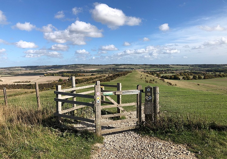
A short but varied circuit on the rolling hills of the Chilterns, this walk has a nice variety of grassy ridges, archaeology, and wide views out over the Vale of Aylesbury. There's plenty of nature too: the Ivinghoe Hills are an SSSI, with areas of unimproved chalk downs, semi-natural woods and scrub, and wildlife including rare butterflies, kestrels, and red kites. Close to a train line, and with quick road access from London and surrounding towns, it's an accessible and scenic half day out for hill-starved southerners, and could easily be extended into the woods to the east to make a longer loop.
Fetching Map
Height Profile
metres / Distance
miles
Detailed description
1
SP9636015958 From the car park briefly follow a woodland path south beside the road. Cross the road at a track (overflow parking) and pick up another footpath heading roughly west through the woods to open ground on the edge of Incombe Hole, a dramatic steep-sided combe. Head south on a well-used path descending around the head of the combe, then heading south-southwest across open pasture to meet the B488.
2
SP9549014942 Cross the car park to regain open downland. There are a number of paths, but for now stick with the high ground, first climbing over an unnamed hill (202m), then crossing a dip before ascending the broad ridge onto the summit of Pitstone Hill. This is the eastern end of The Ridgeway, a prehistoric route that's considered Britain's oldest 'road' and now forms the basis of a classic long distance trail. Beyond the high point of the hill descend briefly south along Grim's Ditch, a section of a mysterious prehistoric earthwork that crops up all across southern England.
3
SP9494514031 Turn west and cut straight downhill: a footpath is visible at the foot of the slope, but it's perhaps more fun to pick up a narrower mid-height traverse path running north. Though it's not far from your turfy outward route, the prickly scrub along the western flank of the hills has quite a different feel (and fewer other walkers). Descend through the thickets to re-cross Grim's Ditch in a hollow, then continue beneath the 202m hill to return to the car park on the B488. Briefly retrace your steps on the main path, then fork left onto a less-trodden trail heading north through sheep pasture before descending steeply into the wooded base of Incombe Hole.
4
SP9563015555 Climbing through scrubby woods and thickets, the path continues up the far slope, making a steep ascent onto Steps Hill. Turn left onto a busier trail, descending north to meet the road where it crosses a col on the ridge.
5
SP9603616335 The much-trodden main path goes north, but it's worth first bearing northwest to climb a minor summit before continuing up the ridge line onto the summit of Ivinghoe Beacon. Site of an ancient hillfort, and the most prominent summit for miles around, this is a fantastic viewpoint.
6
SP9596316854 Head east, passing through a gate. Just beyond is a the very clear circle of a prehistoric tumulus. From here follow the delightful grassy ridge crest eastwards. On Gallows Hill the path cuts left to descend along a field boundary.
7
SP9707716926 A track now heads south-southwest through the fields, before a final quite steep climb brings you back to the car park.
This has been viewed 948 times
Download
OS maps and some other mapping apps don't allow waypointsStatistics
Difficulty: EasyDistance: 5.48 miles (8.82 km)
Total ascent: 295m
Time: 2 – 3 hours (Walking)
Voting:
from 1 votes
Login as Existing User
to rate this walk.
to rate this walk.
Additional Information
Start/Finish:National trust car park on Beacon Road (or alternative parking on the B488), SP963160
Nearest town:
Tring
Terrain:
Easy grassy footpaths
Public transport:
Rail to Tring Station, not far south of the circuit as described.
Maps:
OS Explorer 181 (1:25,000), OS Landranger 165 (1:50,000) Directory Listings:
Find more Listings near this route Tourist info:
Tring (01442 823347); Dunstable (01582 890 270); Wendover (01296 696759)
Further Routes
by Dan Bailey UKH
- A' Chralaig and Mullach Fraoch-choire 4 Dec, 2023
- Meall na Teanga & Sron a' Choire Ghairbh - The Loch Lochy Munros 6 Nov, 2023
- Bynack More 19 Oct, 2023
- Beinn a' Mhuinidh 4 Oct, 2023
- Loch Ossian round - Seven Munros by Train 15 Sep, 2023


Walked up Ivinghoe Beacon once years ago (desperate to get out of London!). Every model plane enthusiast in the south east seemed to be there as well.
I used to live super close. It's a lovely part of the world - not the hills proper of course, but nice quaint countryside.
Also, IMO, there is no need to recommend the carpark - it's much better to get the train to Tring.
Ha! This sounds like it should be on a Half Man Half Biscuit album.
I used to live pretty close too, used to be a regular walk, or mountain bike ride if you start early. Avoid in the rain though, the mud becomes horrible sticky grey gloop. There is also a good much longer walk that goes around the Ashridge Estate boundary.