Rocktype UNKNOWN
Altitude 2532m a.s.l
Faces N
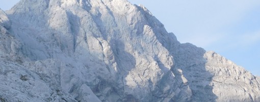
Skuta, with the South Arete in the sun. © Rob Morgan
Summit of this hill
This summit has been climbed in 3 logbooks.Hill features
Skuta is the third-highest peak in the Kamnik Alps and is known for the Skuta Glacier, which is the easternmost glacier in the Alps.
Approach notes
Despite a big approach, the climbing here has a fantastic reputation. Fortunatly, the way in can be broken up with a stay in Cojzova koca, Bivak Pavla Kemperla or Bivak pod Skuto. Whatever your route, the climbing is worth it.
For South Arete & Skuta Dihedral (and also climbs on Struca):
Approaches start from a small free car park at V Koncu (which is at the end of a road going through Kamniska Bistrica valley). First drive to Dom v Kamniski Bistrici. Ignore sat nav details from here, as they can be misleading. Continue straight along the road past the Dom (a sign warns that wheel chains may be needed in winter). Follow the winding dirt road for a few kilometers until you reach the car park directly at the start of the footpath labelled Kokrsko Sedlo.
The most direct route to the climbs is along another footpath going north via Gamsov Skret. The guide book claims this approach can be completed in 4.30hr...good luck. Thankfully Bivak pod Skuto is along the way if you want to break this up.
For a slightly less direct but more stress-free approach, follow the path Kokrsko Sedlo for 2.30-3hrs to Cojzova koca, making ~950m ascent in just 2.5km, to spend the night. In summer this is perhaps best done in the afternoon, as you will mostly be in the shade the whole way. From Cojzova koca, it is a ~2 hour fairly easy approach to the base of the climbs (of which you have a fantastic view most of the way). Shortly after you pass Bivak Pavala Kemperla (1hr), turn right (ignoring signs to Skuta). Follow this marked path until you can make an almost direct detour up some scree to the base of the climbs.
Descent back to Cojzova koca is via the marked path heading west from the summit of Skuta, where you can either spend another night or continue all the way down to the valley. Otherwise, use a map to choose your descent route.
Route Cards
| There are no comments from visitors to this hill. |
Summits, Scrambles, and Easy Climbs on this hill
| Name | Grade | Stars | Type | Logs | Partner Ascents |
|---|
These routes you have climbed by seconding or top-roping.
These routes you have Dogged.
These routes you Did not Finish.
Routes are waiting to be checked by a crag moderator, and may not be accurate. Routes can't be verified by a crag moderator, and they need more information to confirm it. Routes are no longer climbable.