Climbs 1
Rocktype Limestone
Altitude 1711m a.s.l
Faces all
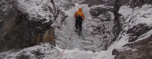
Stu Masterman on WI2 Pitch half way up the 700m route © snakebite
Crag features
The Ghost was established in 1967 on the front range of the Canadian Rockies and consists of 15,317ha (60 square miles) of raw wilderness bordering Banff National Park to the east and north. Its mountains include Mounts Aylmer, Apparition, Oliver and Costigan. The Ghost Valley actually refers to a larger area that is more specifically located approximately 30kms north of Canmore along the eastern border of Banff National Park and east of the Palliser Mountain Range. The Ghost’s glacier carved valleys provide for steep water runoff creating some of the best waterfall ice climbing in Canada. Much of this terrain is considered less avalanche prone than most ice routes in Kananaskis and routes deeper into the national parks. Although not all the Ghost climbs are technically in The Ghost (many of the climbs are in Banff National Park), this whole area of provincial wilderness takes on that identity.
The Ghost Valley is discussed as the South Ghost and North Ghost relative to climbing. The South Ghost is divided into several different areas when discussing waterfall ice: Orient Point, Devil’s Gap, Planter’s Valley, Constellation Valley, Black Rock Mountain and Johnson Creek. The North Ghost includes all the climbs along both sides of the Ghost River. The “North Ghost” routes entail more of a 4x4 drive approach than the “South Ghost” routes.
Description taken from http://www.summitpost.org/area/range/337501/ghost-ice.html
Approach notes
From Calgary or Canmore, access 1A which parallels the TransCanada to the north. 13.4kms west of the Hwy 22 junction in Cochrane is the Forestry Trunk Road (Route 940). Turn north on the Forestry Trunk Road for 23kms to a gated gravel road on your left. There is a trail head information kiosk board here, but no obvious sign. If you find the gate closed, it is imperative that you close the gate behind you. Most climbers only take 4-wheel drive vehicles beyond this point, but depending on conditions, other vehicles can travel the road. This rough road goes for another 17kms until it reaches the
No Access Issues
From Calgary or Canmore, access 1A which parallels the TransCanada to the north. 13.4kms west of the Hwy 22 junction in Cochrane is the Forestry Trunk Road (Route 940). Turn north on the Forestry Trunk Road for 23kms to a gated gravel road on your left. There is a trail head information kiosk board here, but no obvious sign. If you find the gate closed, it is imperative that you close the gate behind you. Most climbers only take 4-wheel drive vehicles beyond this point, but depending on conditions, other vehicles can travel the road. This rough road goes for another 17kms until it reaches the “big hill”. Along the way there is one ice/water crossing. If this hill is muddy or icy or has too much snow, it can be extremely difficult to navigate. Orient Point’s “The Real Big Drip- 200m- V, M7+, WI 7” can be viewed to the southwest from atop this hill. This is a remote area and very little exists in the way of facilities or emergency help.
The “North Ghost” routes entail more of a 4x4 drive approach than the “South Ghost” routes.
At the bottom of the hill, turn right and do your best to follow a sometimes vague, sometimes obvious, track along the right of the wash until it becomes essential to cross the wash heading west and navigate further north crossing a well established bridge over the river and continuing through some big rutts and/or snow drifts until you come to a river crossing. An official government ban on crossing this river is in effect currently (2007) and appears to be an issue at large. Look for signage to that effect. It is regarding trout migration. Whether on foot or vehicle, cross the river and head west following the river.
Description taken from http://www.summitpost.org/area/range/337501/ghost-ice.html
| There are no comments from visitors to this crag. |
Climbs at this crag
| Name | Grade | Stars | Type | Logs | Partner Ascents |
|---|
These climbs you have climbed by seconding or top-roping.
These climbs you have Dogged.
These climbs you Did not Finish.
Climbs are waiting to be checked by a crag moderator, and may not be accurate. Climbs can't be verified by a crag moderator, and they need more information to confirm it. Climbs are no longer climbable.
Moderators Updates to this page are checked by a UKC volunteer snakebite