Climbs 44
Rocktype Sandstone (hard)
Altitude 480m a.s.l
Faces S
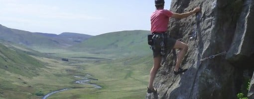
As good as it gets on a fine sunny day? FA of Jeopardy, Craig yr Eglwys. © Dave Williams
Crag features
Craig yr Eglwys is a good little outcrop which offers a number of short climbs from D - E5. It is composed of hard Silurian sandstone and lies just to the north east the Hengwmannedd (Pumlumon) bouldering area, where it stands sentinel over the entrance to the relatively remote yet striking Cwm Gwarin*.
[* Sometime in the 1970s, the OS made a transcribing error which resulted in the mis-spelling of the valley's name on all subsequent and current 1:50 000 and 1:25 000 maps. Consequently it became Cwm Gwerin, although it's correct name is Cwm GWARIN - the 'Valley of the Rabbit Warren', a name which is still very much in local use. By way of contrast, latest edition 1:10 000 OS maps show the valley with its correct name.]
Although the various buttresses are separated by some vegetated and broken rock, virtually all the routes here are worthwhile. The crag has a pleasant, open and sunny aspect. It dries quite quickly after rain and does not suffer from any significant seepage.
The best climbs here are the creme de la creme of Elenydd outcrop climbing and are of a comparable quality to those found on the Peak District's eastern outcrops. The approach favours both the determined and the adventurous, who will be very well rewarded for their efforts by super climbing, peace and solitude. At the time of writing, this great little crag is sorely - and unfairly - neglected.
The crag and its climbing is definitively described in the new Central Wales - Elenydd guidebook.
Approach notes
The approach, as far as the Hengwmannedd boulders, is in Ceredigion. The crag itself is in Powys, the course of the Afon Gwarin being the county boundary.
From the A487(T) Machynlleth to Aberystwyth road, turn off at Talybont and follow the mountain road, signposted Nant y Moch, to the reservoir. Follow the road round the reservoir and over the dam, then go uphill. Just after a cattle-grid turn left and follow another minor road towards Maesnant (O.S. ref 774 881). Park here at the end of the tarmac road, taking care not to block either of the two gates. Most visitors will approach from Ponterwyd on the A44, to reach the same point by following signs to Nant y Moch.
From the parking, go through the RH gate and follow the extremely rough track on foot for a mile, then just before the ford, turn right onto a path which heads upriver past a small plantation of conifers. Follow the hydrographic left bank of the Afon Hengwm for a mile on faint paths to the ruined farm of Hengwmannedd (which has the Pumlumon bouldering area just behind it (O.S. ref 797 893)). The final section can be a rather moist walking experience and wearing wellies is recommended in wetter periods. (TOP TIP: Keep as far right as possible once the ruined farmhouse comes into view and avoid taking a direct route.)
From the Hengwmannedd bouldering area, cross the Afon Gwarin before striking directly up the hillside/scree to the crag. (60 mins)
| There are no comments from visitors to this crag. |
Climbs at this crag
| Name | Grade | Stars | Type | Logs | Partner Ascents |
|---|
These climbs you have climbed by seconding or top-roping.
These climbs you have Dogged.
These climbs you Did not Finish.
Climbs are waiting to be checked by a crag moderator, and may not be accurate. Climbs can't be verified by a crag moderator, and they need more information to confirm it. Climbs are no longer climbable.
Moderators Updates to this page are checked by a UKC volunteer Dave Williams