Climbs 2
Rocktype Limestone
Altitude 1608m a.s.l
Faces all
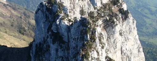
Dent de Lanfon, Haute Savoie, France © David Revill
Crag features
There are at least 13 climbing routes on this crag/peak - see
http://www.camptocamp.org/summits/41537/fr/dents-de-lanfon
12 of these routes in difficulty range TD- to ED4, French 6a to 8c.
The description below does _not_ apply to any of those routes. Rather it applies only to a vegetated scrambling traverse (PD-), which many climbers do without a rope.
_________________________________________________
Dénivelé : 721m
Altitude de départ : 960m
Altitude d'arrivée : 1681m
Temps à la montée : 3h00 to 5h00 (depending on the route taken)
Temps à la descente : 2h00
Carte : IGN 3431 OT
Description
Very impressive view from the top of "the teeth of Lanfon" offers a magnificent view over the whole lake of Annecy.
Crossing the teeth Lanfon is quite exceptional at this level of difficulty: generally very easy (level 3 to 4 climbing and lots of good scrambling), a stunningly beautiful setting (the ridge + views over Lake Annecy) with some breathtaking passages and lots of exposed points that require protection and carefull technique.
It is possible to take beginners, but must be careful to the fact that the route can last over 4 hours, especially if you summit the 2nd peak and there is no escape once on the main section of the route.
A total ban after rain or when the possibility of lightning
A route description and pictures can be found at the following site http://www.cafchambery.com/article.php3?id_article=1432
Approach notes
Three accesses are possible from Menthon St Bernard (Lake Annecy)
a)By Col de la Forclaz, through Le Bois to the chalet D'Alup, then Col des Nante and then up to the Col de Frete. Then decend into the valley and after 200m or so (before the chalet in the vally), take the smaller path on the left that leads to the left side of the Dent's. The access to the route is marked by a large red dot at the bottom of the rock, in line with the start of the 2nd Peak and you have to go round a small pointed hill on the left of the lower ridge line.
b) By Alex (848m) long, with 800m of elevation gain to the cabins below, and painfully long and you then follow the route above from the chalet in the upper vally.
c) By Forclaz pass: Col, continue to Villard, turn left toward the Adventure Centre "Tree climbing", up the valley towards the car park of nearly round, and continue along the forest road to the Chalet Aulp (1424 m), then follow the route from A)
Initially, there are old cables via ferrata style, then use protection by straps/slings on trees, nuts and quickdraws, etc a 30m rope is ok for the standard route for belays, but either 2 x 50m half ropes or a single 70m rope is required for the rappel of the 2nd peak (if you do this) as it is about 30m+ (I have not measured it), take a helmet as there is a lot of loose rock!
| There are no comments from visitors to this crag. |
Climbs at this crag
| Name | Grade | Stars | Type | Logs | Partner Ascents |
|---|
These climbs you have climbed by seconding or top-roping.
These climbs you have Dogged.
These climbs you Did not Finish.
Climbs are waiting to be checked by a crag moderator, and may not be accurate. Climbs can't be verified by a crag moderator, and they need more information to confirm it. Climbs are no longer climbable.