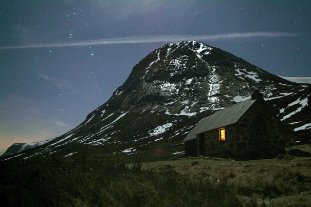
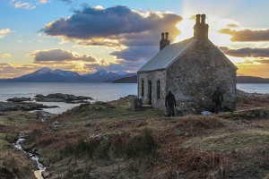
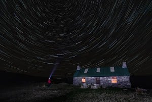
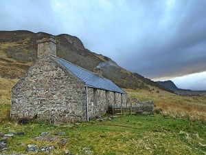
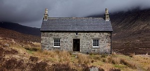
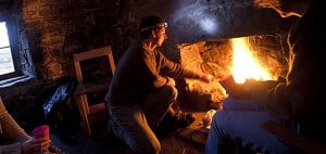
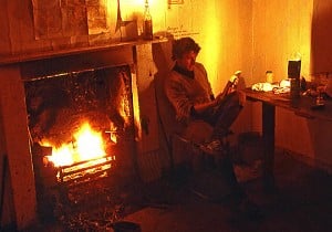
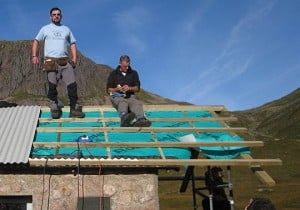
Six Top Scottish Bothy Walks - Minus the Bothy Nights

© Geoff Allan

Although still closed for overnight stays, bothies provide the ideal focus for a day out, says Geoff Allan, author of a new guide to Scottish Bothy Walks. Here are some of his favourites.


In the unpredictable, all-pervasive world of coronavirus, opportunities to walk in the great outdoors have become increasingly precious. I certainly took for granted my freedom to roam the hills while researching routes for inclusion in my new book, Scottish Bothy Walks. But during early lockdown I quickly learned to appreciate the benefits of regular, bite-sized outings. I've never been more conscious of keeping the old cardiovascular system ticking over, my waistline in check and, perhaps most crucially in this current climate, nurturing a feeling of positive mental wellbeing. Covid-19 restrictions have taught us, once more, to value our connection to green spaces and nature, as well as the therapeutic benefits of exercise to our individual and collective state of mind.

A remote coastal bothy with Skye views - ideal destination for a day's walk  © Geoff Allan
A remote coastal bothy with Skye views - ideal destination for a day's walk
© Geoff Allan

Over the summer, Scotland's most popular beauty spots became overrun, but there are always plenty of places across the country where you can escape the crowds. The majority of bothies are off the beaten track, and although still closed for overnight stays, they provide a wonderful focus for a day's walk.

On a dreich morning or a lazy sunny afternoon I have often set out to visit a bothy just to have a look around. When I was compiling the walks for the book, I looked to feature the most intriguing and varied day walks across the whole of Scotland, as well as exciting multi-day adventures. My aim has been to tempt you out into Scotland's rugged and beautiful landscape, whatever your level of ability.

Here are six of my favourite one-day outings based around a bothy, each chosen to highlight how easy it is to appreciate and find solace in the majesty of the Scottish hills.

Burnmouth Cottage, Rackwick Bay and the Old Man of Hoy

Fantastic day trip to the Orkney Island of Hoy, visiting the beachside bothy at Rackwick Bay, before paying your respects to the Old Man of Hoy, a spectacular sandstone sea stack.

Burnmouth Cottage is a brilliant wee bothy  © Geoff Allan
Burnmouth Cottage is a brilliant wee bothy
© Geoff Allan

  • Maps: LR 7 Orkney - Southern Isles,
  • Start/End Grid Ref: ND 202 993 (58.8734,-3.3860) Small parking area at Rackwick.
  • Distance: 11km/7 miles
  • Time: 4–5 hours round trip
  • Difficulty: Easy

Rackwick Bay is the perfect place to linger, breathe in the seaweed-scented air, and marvel at the immense power of the twin master stonemasons, wind and wave. From the teetering sea stack of the Old Man of Hoy, to the huge, rounded boulders strewn along the beach, the wild Atlantic Ocean has sculpted this extraordinary landscape. Pounded by endless swells, the stack was once a stubborn, solitary promontory but its base was eventually undercut to form an arch, which subsequently collapsed during a violent storm in the 19th century. A 200-foot chasm now separates the stack from the cliff, with a causeway of debris creating a precarious land bridge.

Your first glimpse of the giant deep-red sandstone cliffs on the northwest shoulder of Hoy is on the Northlink Ferry from Scrabster, but their true scale only becomes apparent close at hand. Taking a second ferry from either Stromness or Houton, you can drive, cycle, walk or take a minibus to Rackwick. As soon as you make the final turn on the winding single-track road from Moaness, you immediately appreciate why this former crofting community is considered one of the most beautiful places on Orkney.

Rackwick Bay, a dramatic and moody spot  © Geoff Allan
Rackwick Bay, a dramatic and moody spot
© Geoff Allan

Before making the steep ascent to the Old Man, it is worth taking a stroll to the heather-thatched bothy and soaking up the special atmosphere of the bay. Burnmouth Cottage is barely 500 yards from the road and surrounded by a low drystone wall. After a peek inside, clamber over the large rounded boulders that line the beach and enjoy wandering through the dunes back to the car park. Curious seals can often be seen bobbing in the breakers, and you'll hear the mournful notes of oystercatchers and curlews rise up from the marram grass. Once back at the road, take the gravel track (signed for the Old Man) back towards the sea, turning sharp right at the last house, and begin the steady climb out of the bay. Pick one of two turns left up the grassy bank; the second has another helpful sign to the Old Man, and leads up to a kissing gate. From here any confusion is allayed, as the path becomes much easier to follow.

If you make the trip in late spring or early summer, you might be bothered by the great skuas, (or bonxies as they're known locally), that nest in the heather above the cliffs on Rora Head. As well as harassing other sea birds to steal food, the skuas are notorious for dive-bombing the unwary. Sometimes you really feel the need to duck, they seem so close. Finally at the cliff edge, the Old Man reveals itself – an enormous drunken construction of sandstone blocks balanced above the waves on a basalt plinth, with a flat grass carpet at its summit. Fulmars, kittiwakes and puffins nest in the horizontal cracks, while gulls soar above the surf. It is truly an unmissable spectacle. Retrace your route, keeping an eye out for the bonxies, before wandering back down to Rackwick. If you have time it is worth continuing on the track down to Rackwick Hostel and calling into the Cra'as Nest Museum on the way. The traditional croft house and steading have been skilfully restored, complete with basic furniture and a turf roof.

Uags Bothy and the Applecross peninsula

A splendid walk across the remote southern coastal fringe of the Applecross peninsula to Uags bothy, with fabulous views over to the Skye Cuillin and Raasay.

Here comes the weather...  © Geoff Allan
Here comes the weather...
© Geoff Allan

  • Maps: LR 24 Raasay and Applecross,
  • Start/End Grid Ref: NG 710378 (57.3734,-5.8109) Please park at Toscaig pier and not Upper Toscaig.
  • Distance: 11km/7 miles (round trip)
  • Time: allow 4–5 hours, including time spent at the bothy.
  • Difficulty: Easy

Blessed with the Gaelic name A' Chomraich, 'The Sanctuary', by St. Maelrubha, an Irish missionary in the seventh century AD, the Applecross peninsula, has a long-held reputation as a tranquil and isolated backwater. The last lonely outpost between Wester Ross and the Isle of Skye, its landward perimeter protected by a series of towering sandstone buttresses. Before the coast road from Shieldaig was completed in 1975, the sole vehicular access through this natural barrier was via the hair-raising switchbacks of the Bealach Na Ba. One of the highest passes in the UK, the road is often blocked by snow in the winter months. Crofting communities scattered along the coast were still only accessible by footpath or by boat well into the 20th century, and, they had a far closer connection to the sea than to the interior beyond the mountains.

From Applecross village, known locally as The Street, head south past the popular Applecross Inn, and down the coast, to the old pier at Toscaig, now the recommended parking point for the walk into Uags Bothy. Go back along the road to the junction for Upper Toscaig, and walk past a line of cottages to the turning area at the end of the tarmac where there is a signpost to Airigh-drishaig, an old stalker's cottage on the southern coast, and to Uags. Once across a wooden footbridge, head past a ramshackle barn to a second signpost, barely 200 yards from the start of the track. The right fork leads to Airigh-drishaig, the left to Uags, following a muddy path through a farm gate and out onto the open moor. Although indistinct, the trail is far more obvious than it used to be. Wander through the rocky terrain left of a small lochan and down to an obvious circular area of pasture, the site of an old summer shieling. On a clear day the views across to the Skye Cuillin and back to the distinctive flat top of Dun Caan on Raasay are mesmerising, and even when the cloud obscures the horizon the craggy outline of the Crowlin Islands is enough to soothe the eye. Just before the shieling, ford the Allt Loch Meall nam Feadan, a potential obstacle after heavy rain, and look out for a small cairn marking the way ahead on the far side of the flat grassy field. The path becomes much clearer as it continues on, leading up a small rise and then over the heather back down towards the shore.

The final approach to the bothy passes through some captivating pockets of woodland, containing rare Atlantic oak found only in isolated spots along the western seaboard of Scotland, Ireland, France and Spain. Soon Uags comes into sight, perched on a rocky promontory above the tide-line of Caolas Mòr. A sturdy old stone cottage, the two-storey shelter is one of a handful of dwellings in a small settlement that developed in a clearing above a small sheltered bay. The community was finally abandoned in the 1930s. The Gaelic name Na-h-Uamha means 'The Little Caves', and exploration along the shore reveals a number of gaps in the rocks, more readily visible from the sea. Occasionally porpoises are seen out in the bay, and the odd fishing boat heading to or from Kyle of Lochalsh. This really is a magical spot and well worth the effort of the walk in. Retrace your steps back to Toscaig at your leisure, and raise a glass in the Applecross Inn on your return.

Clennoch Bothy and Cairnsmore of Carsphairn

A fine circular walk in old Dumfriesshire, climbing up to the outstanding viewpoint at Cairnsmore of Carsphairn, before seeking out the tiny hideaway bothy at Clennoch.

It's quite the viewpoint  © Geoff Allan
It's quite the viewpoint
© Geoff Allan

  • Maps: LR 77 Dalmellington & New Galloway, Explorer 320 Castle Douglas, Loch Ken & New Galloway
  • Start/End Grid Ref: NX 637948 (55.2286,-4.1449) Parking on roadside verge by Craigengillan
  • Distance: 18 km/11 miles
  • Time: 6–7 hours
  • Difficulty: Straightforward

In a forgotten corner of southwest Scotland steeped in local folklore and pockmarked with evidence of Neolithic and medieval settlements, you'll find the Glenkens Hills. High above them stands the whale-back ridge of Cairnsmore of Carsphairn, the highest summit of three hills named Cairnsmore in the region, celebrated in an old Galloway rhyme: 'There's Cairnsmore of Fleet, and Cairnsmore o' Dee, and Cairnsmore of Carsphairn, the highest o' the three.' It commands a fine view of the Rhinns of Kells, Merrick, and the Firth of Clyde, with the promise of the Arran peaks and Kintyre away to the northwest horizon on a clear day.

Beninner and Cairnsmore of Carsphairn  © Geoff Allan
Beninner and Cairnsmore of Carsphairn
© Geoff Allan

Starting from the cottage at Craigengillan, stride out along the forestry track running parallel with the Polifferie Burn. After just under a mile, go through a metal stock gate as the main track curves away to the left. Cross the the Poldores Burn by way of the old bridge – itself a relic from an earlier age – then follow the overgrown path leading off up to the estate houses at Moorbrock to a new gravel access road. Once through the complex of cottages, ford the Poltie Burn, and then turn sharply left climbing a track through a patchwork of conifers running parallel to the stream. Above the plantation boundary, the track turns 90 degrees left, contouring round the base of Green Hill, before heading along to a forestry watchtower, where the slopes of Beninner come into view.

Tracks penetrate far into the hills  © Geoff Allan
Tracks penetrate far into the hills
© Geoff Allan

Head down the first forestry fire-break to the Poldores Burn, cross a stone dyke, then the stream, and take to the open hillside. Straight up the slope there is a line of weakness in the broken granite fringe protecting the upper slopes (at the shallowest point in the crags) but if you don't fancy a bit of scrambling, traverse left of the steep ground before ascending the brow of the hill. From Beninner's summit cairn, descend west northwest to the Nick of the Lochans, over a stile in the sheep fence, and on to Cairnsmore of Carsphairn. A faint path leads up onto the whale-back ridge, the majestic view opening up as you approach the crest. To the west, the familiar pyramid shape of Ailsa Craig can be seen in the Firth of Clyde, while further south the knotted peaks of the Galloway Hills stretch away into the distance. Boulders are strewn across the plateau, and built up into a windbreak around the OS trig pillar marking the summit. According to local legend, the devil was so upset that a church had been built in Carsphairn, that he hurled rocks from the top of the hill in an attempt to destroy it.

After a gentle descent to Currie Rig, the slope steepens to the valley below, where Clennoch is just a small dot beneath the snaking line of wind turbines on Dugland and Windy Standard. Crossing the Bow Burn (which could be an obstacle in times of spate), you head through a fenced area of birch and willow saplings to the bothy. Once part of one of the most remote sheep farms in southern Scotland, the homestead was finally vacated before World War II then rebuilt as a single-roomed shelter by the MBA in the mid 1970s. The bothy is the furthest point of the walk. From here, a flat, wide forestry track leads south past Moorbrock Hill, and then you pick up the route back to Craigengillan.

Streap and Gleann Dubh-lighe Bothy

Tremendous mountain walk, via a peaceful valley and superior bothy, negotiating a testing ridge up to the pyramid peak of Streap, with views into the Rough Bounds and Knoydart.

Gleann Dubh-lighe - easy to reach, yet feels a world away from the tourist trail  © Geoff Allan
Gleann Dubh-lighe - easy to reach, yet feels a world away from the tourist trail
© Geoff Allan

  • Maps: LR 40 Mallaig and Glenfinnan,
  • Start/End Grid Ref: NM 931 799 (56.8645,-5.3961) Small layby at Drochaid Sgainnir off the A830 'Road to the Isles'. It is easy to miss the layby; two grey bollards mark the entrance.
  • Distance: 17.5km/11 miles
  • Time: 6–8 hours
  • Difficulty: Challenging

Although to an Anglicized ear Streap sounds like an outlying fell in the Lake District, perhaps eulogised in a Wainwright guide, the name has Gaelic roots which are very apt: climb, scale, mount with difficulty; strife or struggle. Through a quirk of fate, the height of this rugged, undulating mountain north of the Road to the Isles, falls just below the magic number of 3000 feet, classifying it as a Corbett rather than a Munro. Consequently, despite being a classic walk, the round of Streap, and its neighbouring tops, is far less frequently climbed than the nearby summits of Sgùrr Thuilm and Sgùrr nan Coireachan, combined to form the equally impressive 'Corryhully Horseshoe'. With no path to speak of once you leave the safety of the glen, except along the vertiginous ridge leading up to the summit, this is a tough, but thoroughly rewarding walk. It is reminiscent of a previous age before the allure of Scotland's high mountains caught the popular imagination, and hillsides became conspicuously embellished by wide tracks and unnecessary cairns. Streap-aidh an duine glioc, the wise man shall scale.

Gleann Dubh-lighe is only a couple of miles down the road from the magnetic attraction of Glenfinnan, but is a world away from the tourist crush. Instead of cars and coaches shoehorned into every available parking space, as the Flying Scotsman chugs across the 'Harry Potter' viaduct in the summer months, look for a small layby tucked away behind a screen of birch trees, a few hundred yards east of a far more prosaic railway overpass. The track to the bothy poses no problems, gently winding its way up the quiet, secluded glen through a dense canopy of conifers. After a short, steeper section, turn sharply right where the track forks, heading down across the river via a sturdy wooden bridge and the bothy comes quickly into view.

Streap - not quite a Munro, but better than most  © Geoff Allan
Streap - not quite a Munro, but better than most
© Geoff Allan

After a quick stop in its comfy interior, continue on up the valley, Streap and its satellite Streap Comhlaidh coming into view just around the next bend. The conifers soon thin out, replaced by birch and ash, and after another half a mile you reach a high deer fence. Beyond is the open hillside. Once through a kissing gate, continue on to a footbridge over the river, close to the ruins of an old farmstead and shieling. Surprisingly this bridge is not marked on either the 1:50,000 or 1:25,000 scale maps of the area. Now the whole ridge is clearly visible, and a decision needs to be made about which slope to tackle to attain the rocky skyline. The most conservative approach is to follow the course of the deep cut Allt Coire an Tuim where birch trees grow in the gully shadows, and continue round to the Bealach a' Chait over the sodden coire basin. Alternatively stick closely to the left-hand bank of the Allt Caol, and climb the steep grassy ridge to the top of Meall an Uillt Chaoil. Although unforgiving, most of the rock obstacles can be avoided. A braver and quicker option is to ascend the tightly packed contours leading up to Bealach Coire nan Cearc, scrambling through the odd outcrop of slippery schist and quartzite.

A broad ridge leads from the summit of Meall an Uillt Chaoil, narrowing as it approaches Stob Coire nan Cearc. Follow a faint trail through a series of bluffs and pay attention, especially in misty conditions, to avoid backtracking, as off-route the rocky obstacles steepen unexpectedly. The path becomes more defined once you clamber up to the top of Stob Coire nan Cearc, where the pyramid summit of Streap rears up into view. The final grassy arête is exhilarating, and less intimidating than it looks. Taking a well-earned break by Streap's summit cairn, enjoying the extraordinary views north and west to the remote terrain of the Rough Bounds and Knoydart. And on a clear day Ben Nevis and the Mamores are just visible on the southeastern horizon.

Taking the leap  © Geoff Allan
Taking the leap
© Geoff Allan

Stepping carefully off Streap's airy perch, a reasonably recognisable path drops down a slender ridge towards Streap Comhlaidh. On the far side of the narrow bealach, a tempting trail cuts across the slope to avoid the short steep ascent to this secondary summit peak. If you head to this second top, quickly cross to a grassy triangular high point before starting the long slow descent to the valley floor. Rejoin the other path before it peters out as the ground steepens. Aim for the track that leads up to the watershed of Glen Camgharaidh, crossing a couple of streams incised into the slope. With some relief wander down the boggy track to the final obstacle of the day, crossing the Allt Coire nan Chùirn as it tumbles down towards the Dubh Lighe. When in spate this could be tricky, though it is possible to jump across the channel at its narrowest point. From here head back to the footbridge and descend to the bothy, turning one final time to marvel at what you have accomplished in one day.

Beinn a' Chreachain & Beinn Achaladair via Gorton Bothy

Challenging mountain walk along the spine of the Bridge of Orchy hills above the awesome expanse of Rannoch Moor, via the welcome outpost of Gorton Bothy.

Gorton Bothy  © Geoff Allan
Gorton Bothy
© Geoff Allan

  • Maps: LR 55 Glen Orchy and Loch Etive, Explorer 377 (Gorton is just off the map)
  • Start/End Grid Ref: NN 314 438 (56.5564,-4.7448) Large car park on track signposted to Achallader farm off the A82 Glasgow to Fort William, 3 miles N of Bridge of Orchy
  • Distance: 25.5 km/15.5 miles
  • Time: 8–10 hours
  • Difficulty: Challenging

The Bridge of Orchy hills are a collective of five Munros, the four major summits: Beinn Dorain, Beinn an Dothaidh, Beinn Achaladair and Beinn a' Chreachain, linked by a long winding ridge. Viewed lightheartedly as a rock band, Beinn Dòrain would be the lead singer, showy and loud, while Beinn a' Chreachain – the highest point in the range – the quietly superior lead guitar. Beinn Achaladair, might be the drummer, kicking out the beats, and Beinn an Dothaidh, the ever-reliable bass, holding the ensemble together. The fifth peak, Beinn Mhanach, shuns the limelight, much like a session musician with an occasional solo. Completing the entire ridge-line is an ambitious undertaking. Each major summit is over 1000m in height, and ascents are typically split into two separate expeditions. The less-demanding walk involves doubling back over Beinn Dorain and Beinn an Dothaidh from Bridge of Orchy Hotel. The stiffer proposition is to tackle the two outlying peaks, Beinn Achaladair and Beinn a' Chreachain, from Achallader farm. Gorton Bothy is a useful stopping point, before the ascent to the ridge.

These Munros offer bird's eye views over Rannoch Moor  © Geoff Allan
These Munros offer bird's eye views over Rannoch Moor
© Geoff Allan

The hum of speeding traffic quickly recedes as you march along the wide gravel track towards Achallader farm from the car park, (now sited a short distance from the road rather than in the old courtyard). This is an ancient drovers' road through the floodplain of the Water of Tulla, a route frequented by cattle rustlers, clansmen and Hanoverian troops over the course of its long history. Ignore a signpost directing you up the hill towards Coire Achaladair (used as the descent route for this particular outing), and walk on to the farm, guarded by the ruins of a 16th -century tower house. From the farm, head down a neat, turf-capped drystone dyke to the ford of the Allt Coire Achaladair, the one significant obstacle on the route to the bothy. In spate this could be a risky proposition, though it is possible to follow a sheep trail upstream to a new concrete bridge (it serves a small hydroelectric scheme further up the glen), returning on the far bank. Continue through the pasture down to the stony bank side, ignoring a second ford left through the channel to the farm at Barravourich. After another half a mile, finally cross to the river's northern bank via a rather dilapidated vehicle bridge. Across on the far bank, the wonderful old Scots pines of Crannach Wood hug the hillside on the lower slopes of Beinn a'Chreachain, recently fenced off to encourage new growth. Eventually the bothy comes within sight, just off the main path. The former farmstead is a respectable, if spartan, refuge and was occupied as recently as the 1950s.

Beinn a' Chreachain's dramatic Coire an Lochain  © Geoff Allan
Beinn a' Chreachain's dramatic Coire an Lochain
© Geoff Allan

Return to the main track, crossing back over the river on a wooden footbridge, before passing under the railway line – a constant companion along the walk up the glen. Briefly follow a muddy ATV track under a line of pylons, and up the side of the fenced plantation by Bad na Gualainn. Now pick a line up the steep grassy slope: sticking to the increasingly obvious ridge to the left is the easiest gradient. Once height is gained, a breathtaking vista of Rannoch Moor opens up to the horizon with a ring of mountains visible on its far boundary. The Black Mount, Glencoe, and on a clear day Ben Nevis and the Mamores, float above the vast dappled carpet of heather, peat bog, boulders and ribbon lochs. Approaching the unnamed top at 894m, the beautiful Lochan a'Chreachain is revealed, nestling beneath the vertical cliffs of the coire wall. From this high point, a faint path leads on to the distinctive summit cairn of Beinn a' Chreachain (Hill of the Clam Shell), a pyramid of shiny mica schist and quartzite.

The distance to over to Beinn Achaladair looks rather daunting, but the ground is quickly covered. Descend steeply down the rocky scree and take the obvious path across to the grassy slopes of Meall Buidhe, before dropping to the Bealach an Aoghlain. The ridge up to the long, flat top of Beinn Achaladair is quite steep and eroded, especially in its lower section, but the path is obvious and very little scrambling is involved to gain the upper slopes. Confusingly there are two distinctive summit cairns, and the high point at 1038m is a small pile of stones somewhere in between. The stunning view is certainly worth all the exertion – Stob Ghabhar and the sequence of craggy peaks undulate towards the horizon, providing a fine backdrop above the serene, tabular shape of Loch Tulla. And further to the west, the distinctive beacons of Beinn Starav and Ben Cruachan draw the eye towards Oban and the distant sea. Although it is possible to throw caution to the winds and head straight down the western slope of Beinn Achaladair to the valley below, you would be well advised to take the obvious path round to the bealach above Coire Daingean, where a small cairn marks the descent into Coire Achaladair. Ford the Allt Coire Achaladair with care below a cascading waterfall, at the confluence of two feeder tributaries (this could be an obstacle when in spate), then continue down the western bank of the burn following a muddy path towards Achallader farm. Then cross a fine old iron bridge which arcs over the railway line and soon after, take the diverted path on the left, which skirts round the farm and back to the car park.

Ben Macdui from the Linn of Dee, via Bob Scott's Bothy and the Hutchison Memorial Hut

Exceptional mountain walk through long atmospheric glens and beautiful pine woods to the sub-arctic summit of Ben Macdui, the highest point of the Cairngorm plateau.

The Hutchison Hut in remote Coire Etchachan  © Geoff Allan
The Hutchison Hut in remote Coire Etchachan
© Geoff Allan

  • Maps: LR 36 Grantown and Aviemore/43 Braemar and Blair Atholl; Explorer OL57 Cairn Gorm and Aviemore, OL58 Braemar, Tomintoul & Glen Avon
  • Start/End Grid Ref: NO 063 898 (56.9899,-3.5429) National Trust car park at the Linn of Dee
  • Distance/ 32 km 20 miles
  • Time: (summer conditions) 10–12 hours (7–9 hours from Bob Scotts Bothy) Cycling into the Mountain Rescue Post at Derry Lodge is one option to shorten the day.
  • Difficulty: Challenging

Hidden behind the huge granite ramparts of Am Monadh Ruadh (The Red Mountains), at the heart of vast wilderness stretching from Strathspey to Deeside, stands the domed peak of Ben Macdui, Britain's second highest mountain after Ben Nevis. Simply translated as 'Hill of Macduff', after the Earls of Fife who once held sway here, the summit was held in great esteem by locals as the highest in the land. When, in 1847, the Ordnance Survey established that Ben Nevis was taller, they were aghast and mounted an ambitious campaign to build a giant cairn on the hilltop. Fortunately, this faltered for lack of funds.

Passing out of the pine woods into the more barren upper glens  © Geoff Allan
Passing out of the pine woods into the more barren upper glens
© Geoff Allan

Although generally benign in midsummer, the high plateau of Ben Macdui has a fearsome reputation in the winter season, which can begin as early as September and can last through until May. Exposed to the elemental forces of wind and ice, and often cloaked in seemingly impenetrable cloud, this can be a wild, unforgiving place as well as an eerie environment that challenges the senses. In mist or towards nightfall, you can understand why the enduring legend of Am Fear Liath Mòr (the Big Grey Man) has persisted over the years. Haunting the top of the mountain, the spectre is said to induce unease and even panic.

Any ascent of Ben Macdui can feel daunting, but the experience of traversing the desolate, rock-shattered plateau leaves you wide-eyed and exhilarated. The consistent high altitude across the Cairngorms massif is the closest the UK comes to experiencing the Arctic, and although on first inspection the terrain appears barren, dwarf pines and flattened branches of juniper and willow creep across the wind-blasted ground. The northerly ascent from the ski centre at Cairngorm Mountain Resort, over Cairn Gorm and across the plateau, is the most straightforward route up the mountain. Approaching from Deeside to the south is far longer, but the opportunity to experience more of the Cairngorms' majestic scenery is not to be missed. The irresistible combination of mighty rivers, sweeping glens, high lochans and Caledonian forest draws visitors back time and again.

Bob Scott's might currently be closed, but it's worth a look in passing  © Geoff Allan
Bob Scott's might currently be closed, but it's worth a look in passing
© Geoff Allan

From the National Trust car park at the Linn of Dee, take the well-trodden path signposted to Glen Lui through the woods, turning left onto the main track heading into the interior. As you continue towards Derry Lodge, the high summits begin to feel a little closer, though Ben Macdui will remain out of sight until well into the walk. Turn left again after the bridge over Lui Water and after a couple of easy miles, the old lodge appears in the distance, surrounded by the first pockets of venerable Scots pines. Before the lodge, down by the riverbank and hidden by a heather-topped terrace, you can take a detour to Bob Scott's Bothy, the club hut of a loyal, independent band of outdoor folk.

From the bothy, head back up to the track, and then wander down past the Mountain Rescue Post to the confluence of Lui Water and Derry Burn, where handsome swathes of mature Scots pines hug the lower slopes of Derry Cairngorm and Sgòr Dubh. Cross the metal footbridge over the Derry Burn, and take the path signposted to Coylumbridge and Aviemore via the Lairig Ghru. It continues through the last pockets of pines into Gleann Laoigh Bheag, to the mysteriously named Robbers' Copse (Preas nam Meirleach). Approaching the Luibeg Burn, leave the main path and take a smaller trail which contours below Carn Crom, and leads into the upper reaches of the glen, where the curving ridge line of Sròn Riach soon comes into view. Carefully ford the stream that tumbles down from Coire Sputan Dearg and ascend the ridge, quickly gaining height. From the rocky summit of Sròn Riach, the commanding bulk of Ben Macdui finally reveals itself, while further to the west, the spectacular sculpted coires of Cairn Toul dwarf its lowly neighbour the Devil's Point.

Second highest point in Scotland  © Geoff Allan
Second highest point in Scotland
© Geoff Allan

The most direct route to the summit plateau is a scramble up the steep boulder field close to the rim of Coire Sputan Dearg and on to Stob Coire Sputan Dearg, where there is a fine view below to Lochan Uaine. Alternatively, follow a faint path contouring left round to Caochan na Cothaiche, and tackle the steep grassy slope leading up to the spring of the Tailor Burn (Allt Clach nan Taillear). Once on the plateau from either route, locate the path leading up from Loch Etchachan that heads west up to the Sappers Bothy (marked as a ruin on the 1:25,000 map). The shelter was built for the surveyors who took measurements back in the 1840s to establish the mountain's height. In misty conditions, or with snow lying on the ground, it is best to take a bearing because, unlike the path across from Cairn Gorm, there are no cairns to guide you. With some relief, finally reach the summit where there is a large cairn, trig pillar and viewfinder. If the weather has been kind, a glorious tableaux is revealed around you above the edge of the wide plateau rim: Cairn Toul and the remote coires of Braeriach to the west, round to Cairn Gorm, and east through waves of undulating granite hills to Ben Rinnes and Aberdeenshire. And hopefully there will be no encounter with the Big Grey Man!

The return leg begins by backtracking down the path towards Creagan a' Choire Etchachan, skirting the northern rim of Coire Sputan Dearg, and down to Loch Etchachan. In low visibility it is easy to lose your way and trend north into the Garbh Uisage Mor on the east side of Càrn Etchachan where there is a precipitous dead-end above the sheer-sided Shelter Stone Crag. Look out for the edge of Coire Sputan Dearg as it sudden appears, (the teetering scree at the mouth of Narrow Gully is particularly treacherous), only relaxing when you reach the loch – the highest of its size in the UK. Here a wide scree path continues down into Coire Etchachan, to the Hutchison Memorial Hut. Now head down to the bridge over the Coire Etchachan Burn before joining the path which descends from the Fords of Avon. The final obstacle heading back to Derry Lodge is crossing the powerful Glas Allt Mor, which could be a problem in times of spate. Once across, continue down the wide floodplain of Glen Derry, passing two plantations of Scots pines, and finally reaching the mature forest. The main track contours above the valley floor before dropping back down to the outpost at Derry Lodge, and finally, exhausted yet elated by the expedition, arrive back at Linn of Dee.

Note: This is a demanding route, in one of Britain's most hostile environments. Deteriorating weather conditions can be seriously compromising on the summit plateau where expert navigational skills are essential. Ben Macdui is surrounded by very steep ground to the W and to the E the vertical cliffs of Coire Sputan Dearg need to be avoided on the descent. In winter, blizzards, white-outs and gale-force winds can make the summit very hazardous.


Scottish Bothy Walks: Scotland's 28 best bothy adventures by Geoff Allan (Wild Things Publishing). Signed copies are available exclusively on my website www.geoff-allan.co.uk

UKH Articles and Gear Reviews by Geoff Allan


Loading Notifications...
Facebook Twitter Copy Email