


Destination Hillwalking in Wild West Texas
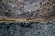
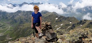
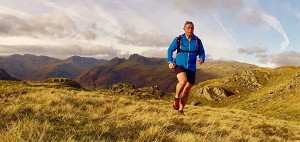
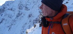
In Spring 2022, Munroist Ian Robertson went to the desert hills of west Texas in search of something a bit different, and ended up having one of the best trips of his 30-year hillwalking career.
Ireland has some of the best hillwalking on the planet, but it's surprising how few walkers this side of the sea seem to know it. Local expert Stephen McAuliffe offers a brief introduction to the key areas and ranges in the Republic and the North, with input from recent Irish walking convert Danny Sercombe, who moved there from the UK knowing little about the mountains.
Ireland is blessed with a wide variety of landscapes and has some of the very best mountain areas in these islands. In places you can find a wilderness akin to the Scottish Highlands, where peaks rise from vast plains of wild bog. In others, spectacular peaks that soar to over 1000 metres - and these give some wonderful walking. On top of all this, some great ridges and scrambles are also to be enjoyed. This wild and rugged landscape is a mecca for tourists from all over the world. There is so much to explore and enjoy. So where to start? We've broken the country down into its main areas.

"Growing up in the UK, Irish Mountains were always a distant mystery" says Danny.
"I knew that they existed but I didn't know anything about them, except the common (and largely untrue) assumption that it rains too much in Ireland to be able to enjoy being outside.

"My first sighting of Ireland was from the summit of Skiddaw. On that clear day I could see over the Irish Sea to the coast of Northern Ireland and I think it was the first time I ever considered the idea of visiting. A few years later I ended up moving near Dublin for work, and I fell in love with the place.
"I don't think that my prior indifference is unique, and Ireland often seems overlooked in books and magazines dedicated to the mountains of the British Isles. Ben Nevis, Snowdon and Scafell Pike are all household names, but few people outside the Island know much about Carrauntoohil or Slieve Donard (the highest mountains in the Republic and Northern Ireland respectively). In truth, visiting Ireland is easy. There are lots of accessible hikes and climbs (as long as you don't mind an occasional lack of paths) and there are some very good guidebooks and maps too..."

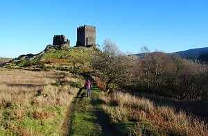
The Wicklow mountains form a large upland area that stretches from the streets of Dublin to the south of County Wicklow and covers an area roughly the same size as Snowdonia. Indeed on a clear day you can see clearly the other range across the Irish sea.
The region is so close to the capital that the mountains actually surround the south of the city like a giant defensive wall. The landscape is big, and the mountains broad and surprisingly remote feeling, despite the nearby metropolis. Indeed this is the most extensive region of mountainous land in the country.
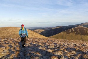
There are 39 mountains over 2000 feet to be found here with the highest being Lugnaquilla. This reaches up to 925 metres and is the northernmost 3000er in Ireland and one of only three that pass this magic number outside The Macgillycuddy Reeks (but more on them later). When the cold comes from the east this mountain can offer excellent winter walking and climbing. These mountains aren't the sharp peaks that can be found to the west, but are instead rolling peaty domes. For most walkers, the beauty of these mountains is their sense of space. Here, when the wind blows and perhaps the mists descend, you can find yourself in the middle of a wilderness adventure. It's a place where you can let your imagination run wild as you traverse the often pathless windswept ground.
 © cham4807, Dec 2010
Despite its proximity to Dublin (you can literally walk to the mountains from the tram) it is very possible to get away from it all by choosing some of the less popular corners. In some parts you can pass the entire day without seeing another soul. Access is relatively easy, with major roads radiating down either flank of the range and many options presenting themselves. Blessington on the western side offers access to the beautiful Glendalough while Roundwood to the east is a fine place to base yourself with plenty of hikes on offer nearby. Road access to the inner areas is via just three passes, and each of these rises to over 400 metres.
"I would recommend Tonelagee (817m) as my favourite Wicklow mountain" says Danny.
"Looking down from the summit gives what must be one of Ireland's most romantic views across an impressive coum containing a perfectly heart-shaped lake. We hiked up with a bivvy bag and a bottle of wine back in 2016 and laid our sleeping bags on the top to watch the sunset. There was no ambient light and as it got dark we were able to spot constellations, planets, shooting stars and even the international space station going overhead. I can't think of many places I've been to that are as pitch black at night."
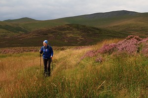
Just to the south of the range and drifting into County Wexford, the Blackstairs Mountains rise out of wide fertile plains. This small group of mountains whose highest Mount Leinster rises to 794 metres, fizzle out to the south and form the final abutment of the highland area. From here the mountains of County Waterford can be seen, and this is where we head next...
This area has three distinct and separate ranges to choose from. The Comeragh Mountains in County Waterford offer steep glaciated coums to the east with a high wild plateau and more rolling heathery hills to the north and west. Running roughly on a north south axis they stretch from Clonmel in the north to Dungarvan on the south coast. The views from the tops are expansive and the area offers a variety of wilds rugged walks. One of the most popular is the circuit of Coumshingaun which goes around one of the finest glaciated coums in the whole country. The summits here are mostly over 700 metres and as they rise from practically sea level they have an excellent high wild feel.
Just to the east of the Comeraghs lies another compact range called the Knockmealdown Mountains. These rounded heathery mountains rise to nearly 2500 feet and run in an east to west axis. Despite the proximity of the other mountain ranges, these distinct hills form a very separate upland area from the rest and are surrounded by wide agricultural valleys. Despite the overall compactness of the range there is a surprisingly spacious feel to the walks hereabouts and once you are on the broad heathery ridges you do feel very removed from it all.

Next up, and just to the north of the Knockmealdown Mountains rise the Galty Mountains. Again this compact range rises completely separately from the others, and runs from east to west. Although you can glimpse the sea from the summits you are very much inland here. Galtymór (or Galtymore) rises to 918 metres and so is another of Ireland's 3000 ft plus mountains and is classed as the only one not unduly influenced by the sea. The main ridge runs east to west and short spurs radiate on either side to the north or south. This facilitates some excellent horseshoe walks with some fine longer enchainments also possible. The lure of the 3000er means that Galtymór is quite popular (relatively speaking) but you are very unlikely to find too many people elsewhere on the range. There is some steep ground on the northern flanks but in general these high broad boggy mountains offer excellent walking. Just don't expect to return with dry clean boots at the end of the day... paths are at a premium.

"One reason to recommend Ireland is how welcoming the people are, and our welcome here could not have been warmer" says Danny.
"After initially trying to warn us off hiking 'the big mountain' the owner of our B&B instead gave us as much fruit as we would take to keep us well fed on our day out. The land here rises up from a flat plane that stretches for miles, meaning that the views are exceptional. On a clear day like the one we had, it is possible to see both Carrauntoohil in Kerry and Lugnaquilla in Wicklow from the top."
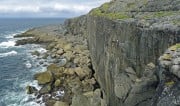
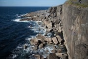
The piéce de résistance... The honeypot... Call it what you will, but one thing it undoubtedly is is wild and wonderful. In this huge area lie some of the finest and wildest mountainscapes to be found in Ireland. One of the big mistakes people make is to focus in on The Reeks to the exclusion of all else. What a mistake that would be. The area can be broken into three distinct sections on separate peninsulas that spear out into the wild Atlantic.
A contender for the best hill area in Ireland? Though the mountains are all under 700 metres in height, the ground is very rough and the hiking difficult. Progress from one mountain to the other is often across rocky bands that always seems to cross the way you want to go. This adds considerably to the difficulties of a route. All those metres up and then down, coupled with the often tortuous route you need to take, makes for surprisingly long days.

The area's highest is called Hungry Hill, and it is a savage mountain. Despite only reaching 685 metres it is a rocky brute that requires care to reach its steep sided summit, especially in bad weather. Not that height is everything and if you travel to the western extremities you reach the old mining village of Allihies which is loomed over by hills that don't quite reach 500 metres, but trust me, the effect is stunning. Here you feel that you have reached the ends of the earth and perhaps you have as the next landfall is all the way across the Atlantic in North America. On the central spine of the peninsula you are never too far from the sea but remote valleys cut in towards the centre and offer access to seldom trodden ground. The mild climate means that ancient oak woodlands are found on either side with semi tropical gardens giving the place an otherworldly feel.
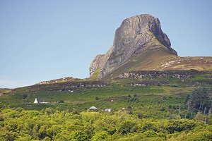
This large peninsula is home to the highest mountains in the country, The McGillycuddy Reeks near Killarney, and stretches west to Valentia Island. From here you clearly see those fantastical rocky outcrops "The Skelligs" where some of the recent Star Wars films were shot.
Starting at Killarney (though the mountains begin much further east), 600 square miles of wild wonderland stretches before you. Leaving the Lakes of Killarney behind you come first to the biggest and most spectacular range in Ireland, the Macgillycuddy Reeks. This relatively compact group is home to eight peaks of over 3000 metres topped off by the imperious Carrauntouhil at 1039 metres. In these mountains some excellent mountaineering adventures can be had in both summer and winter, the most famous of which is the magnificent Howling Ridge, one of the greatest VDiff mountain climbs in these islands.

Carrauntouhil has become very popular and it is a rare thing these days to find yourself alone here, but by exploring the nearby East Reeks,you can have the area to yourself as often as not. Also on this side there is perhaps the best arete in the country, that stretches from No match for crag id:"Cruach Mhór" to No match for crag id:"Cnoc na Péiste". This super airy Grade 1 or 2 scramble on excellent rock stretches for over a kilometre - a summer classic, and a serious test under snow.

Further west the mountains are lower, but no less appealing. Here you can enjoy big days in remote tops on what are predominantly trackless hills. Boggy ground makes for tough progress and in places steep rough ground builds a sense of self reliance. The further west you go the more the Atlantic begins to frame the landscape, and the views are all the better for that. There are few things to beat walking off the mountains and going for a dip at one of the many fabulous beaches and coves that are to be found here.
Did we that the Beara Peninsula was the best? Well come to think of it now, we're not so sure. That's what these places do to you. When you build a bank of memories then it can be hard to choose the best. Stretching from Tralee out as far as The Blasket Islands, this long narrow peninsula offers some of the best mountain days in the country.

The crowning glory of the area is without doubt Mount Brandon (aka Brandon Mountain), which at 952 metres is another 3000er. Before you reach Brandon the Slieve Mish mountains rise to over 850 metres and these broad peaks offer up some great hikes. The Brandon massif however is the biggest and baddest in the area and traversing its ridges is sure to provide memories that will live long in the mind. If it's scrambling you're after, try the magnificent Faha Ridge. Dramatic cliffs and corries plunge along the eastern flanks while gentler slopes to the west sweep right down to the ocean. Once you drop down from the summits you can choose from some of the most exhilarating coastal walks, none more so than "The Three Sisters", a glorious hike along precarious and spectacular cliffs, that fills the senses.

Less celebrated than Kerry, perhaps, but home to a whole lot of wild, rough walking... not to be missed!
Having passed up through The Burren (a magical place of limestone and world class rock climbing) you reach Galway and turn west. After you pass through the little town of Oughterard you are suddenly immersed in one of the most iconic landscapes in Ireland. Sometimes it is hard to define exactly why some landscapes are more beautiful than others, but the juxtaposition of all the features here is something special. Sea, lake, mountain and moor are here in abundance and everything just seems to fit. It immediately relaxes and excites in equal measure.

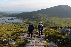
The first ranges you see are the Maumturks and the iconic Twelve Bens. Steep, rocky and beautiful, these mountains, despite their modest height (barely over 700 metres), are not to be underestimated. Most outings on them are big and hard, as the sides are steep and the drops between tops substantial. The often convoluted nature of the ground makes good navigation in less than ideal conditions important. On The Bens for example you can enjoy several hikes of similar quality and difficulty as the Glencoaghan Horseshoe. This is rightly regarded as one of the finest hikes in the country and at approx 17 kilometres long with 1700 metres plus of ascent, you get some idea as to why these mountains deserve respect. The surrounding bog and lakes are just above sea level so every metre to each summit is earned. Carrot Ridge (D), also on The Bens offers an excellent mountaineering adventure at Diff grade, while other harder ridges can be found nearby.

"I was nervous when we first visited as we were there to climb Carrot Ridge: about 300m of roped climbing and scrambling on one of Ireland's best mountaineering routes" says Danny.
"It felt like a big day out and even the walk into Bencorr (711m) was a bit of an adventure, with no paths, rocky ground and fast flowing rivers to cross. The climb itself was 5 strung out pitches with sparse protection but, despite my relative inexperience, I stopped being scared and found myself lost in the beauty and isolation of the dramatic landscape. It's a great area to have an adventure in."
Just across the spectacular Inagh Valley lie the Maumturks. Although they are similar looking to the Bens from below they are in fact a long serpentine rocky ridge that is cut through in a few places by spectacular gaps. Again navigating this rough ground in mist can be difficult, but when the skies are clear this is a special place to be.
North of "The Bens" and you cross over into County Mayo and here many small ranges vie for your attention. Mweelrea, rising straight up from the ocean to over 800 metres, is riven with massive coums, cliffs and views. This is the area's highest in Connaught and for many walkers, one of the most wonderful massifs in all of Ireland. Other slightly lower groups are just nearby and the whole complex combination is stunning and the vista is hard to beat. Mayo is a big county and the Mweelrea area is by no means the only mountainous part. Croagh Patrick is an iconic mountain lying just to the north which affords stunning views down to Clew Bay. While you are up there you may be moved to prayer as it is one of Ireland's "holy mountains" and a place of pilgrimage for thousands on one Sunday each summer.

Don't forget to include Achill Island on your trip. Ireland's largest island has some wonderful walks including Achill Head and Croaghaun. This mountain claims to have the highest sea cliffs in Europe and when you stand on the 688 metre summit and gaze carefully down the precipitous drop to the waves crashing against the rocks far below it is easy to believe it. Back on the mainland, the eye is drawn to the large heathery peaks of the Nephin Range. This range is generally recognised as the most remote area in the whole country, with few roads cutting across the vast blanket bogs that completely surround it. If you want to get away from it all and get that feeling of having left the modern world behind then spend a couple of days crossing this wild place and experience dark skies where no light pollutes your view of the stars.
As you head towards Donegal you pass through Sligo and another small but beautiful range (The Dartry Mountains) that is worthy of exploration. Perhaps the most well known in the region (though not the highest ) is Ireland's "Table Mountain", the beautiful No match for crag id:"Benbulbin". Though it only reaches modest height its flat summit plateau is guarded by cliffs - an impressive sight. Many fine walks can be enjoyed in this area and chances are you will have the hills to yourself.

Continuing north you enter Ireland's most northerly county, Donegal. Like all wonderful places their remoteness and the effort required to getting there makes you appreciate them all the more. Donegal County is one such place, and it offers some of the finest and wildest landscapes in the whole country. There are two main mountain ranges to be enjoyed, starting with the rather beautifully names Bluestack Mountains. These rounded boggy hills offer remote wild walking and plenty of long days can be enjoyed on their rough summits.
Further north in the county lie the Derryveigh Mountains which are the wildest and most rugged in the area. I guess it should come as no surprise, given the fact that the next ranges to the north lie in Scotland, to find Errigal Mountain's slopes covered in scree. This is the highest in the county and its elegant conical shape make it a recognised mountain throughout the land. The gorgeous Glenveagh National Park is one of the best places in Ireland to spot Golden and While Tailed eagles. The rather forbiddingly named Poisoned Glen is a hauntingly beautiful place and when the mists whirl in the wind it can best be described as "otherwhere".

Another place in Donegal that has to be mentioned is the Slieve League cliffs in the southwest of the county. At 600 metres they also lay claim to being the highest sea cliffs, as they are a little steeper than in Achill - but whatever the rights or wrongs they are stunning and a sight not soon forgotten.
The Mourne Mountains in Northern Ireland are fairly accessible from from either capital city. Studded with granite tors for which the range is famous, they are much sharper and greener than the Wicklow Mountains and, as the song states, they sweep down dramatically into the sea.
"It was only this winter that we hiked up the steep slopes of Slieve Binnian (747m), where we needed ice axes to scramble up onto the small, rocky summit" says Danny.
"We were lucky enough to have the whole mountainside to ourselves and the fallen snow felt like a blank page, unwritten apart from our own footprints."

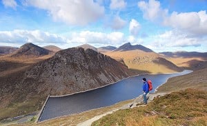
The highest mountain in the Mournes, and the biggest in the North, is Slieve Donard (850m). Its summit is crossed by the Mourne Wall, a dry stone structure that was built between 1904 and 1922 to mark the catchment area of the Silent Valley reservoir that services Belfast. The wall is 35km long, crossing many of the best peaks and it would be an epic trip to follow its length on a single or multi-day trip. From the top of Slieve Donard you can look down onto coves and inlets all along the Northern Irish Coast, spot the Belfast Hills and even look across to Lough Neagh, the largest lake by area in the British Isles.

Is that it?...not by a long shot. The mountain areas of Ireland are many and varied, from the wild boggy inland summits, to the rugged mountains that jut out into the vast Atlantic. I suspect that there is more to be found than you might think,. Taken individually each group isn't huge but when you look are the picture as a whole the the choice is varied and the scope is vast. The weather is influenced by the Atlantic so expect similar weather to the west coast of Scotland or the Lake District. Certainly you may get rain but believe it or not you will get your fair share of sunshine as well. Get out there.

 © Stephen McAuliffe
When to go
Ireland is great to visit all year round but don't count on snow being here in winter. Snow is a luxury when we get it but is less frequent in Ireland than in Great Britain.
How to get there
Flights are very cheap from airports across the UK. There are also various ferry options if you want to bring a car.
Getting around
Public transport isn't great outside of Dublin, so either bringing or renting a car is probably essential.
Guidebooks and information
Collin's Press do numerous hiking guides covering every mountainous area in Ireland. For climbing, Mountaineering Ireland have books covering the major areas. Maps are available from Harvey and OS Ireland.
For further information and inspiration see:
In Spring 2022, Munroist Ian Robertson went to the desert hills of west Texas in search of something a bit different, and ended up having one of the best trips of his 30-year hillwalking career.

Daft online reviews occasionally make it into the mainstream media, and they don't get much sillier than complaints about mountains. Since we're not above laughing at the less hill-savvy, we've mined Tripadvisor for some...


Comments
Y’know what gents? That’s not bad at all ;-)
For a lot more info in vast detail, try mountainviews.ie (says an entirely unbiased member of their committee, who is also an Englishman who moved to Ireland).
We have done a couple of trips hillwalking in the Reeks and Dingle and Beara peninsulas. Corrantoohill (various spellings exist) is a brilliant hill and significantly less crowded than high points in other parts of the British Isles. We liked the walking which was wild, empty and at times quite savage BUT there is a real issue over access that the article doesn't mention. A number of times we were approached by landowners who told us we were not welcome to walk over their land. There is not a public right of way/right to roam in Ireland. Finding safe places to leave a car is difficult and working out how to avoid farms is even harder. One lady told us she had no objection to us walking up her farm track to access a hill - but her husband would and he was a bit further up. She then added that he was armed with a shotgun. We took the hint.
Another heads up for MV. Nice to see my local stomping ground Wicklow and Dublin mountains but what about the Slieve Blooms?
An exiled Scot.
Many thanks for the endorsement :-)
The Slieve Blooms? Hills ‘for the connoisseur’, shall we say....
Regarding access, yes, it isn’t as straightforward as in Britain. But it’s improving...in ten years of walking over here I’ve been asked to leave once. It pays to do a bit of research in advance (once again cough, mountainviews.ie cough). Oh, and be sure not to park like a pillock.
Yup, this has been my occasional experience too.
90% of the time friendly welcoming folk but there is an undercurrent of “Get orf my land” intolerance which is quite jarring to a Scottish hill walker. I could also mention the issue of difficulty parking near the mountains at the road end but that’s common in almost every country.
Really, a terrific place to visit but could do a bit better. Given the progress of political change in the country, its a shame that access laws lag behind.