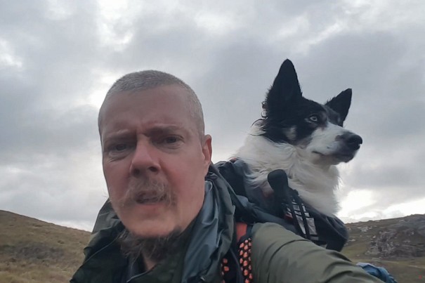
How to Walk the Cape Wrath Trail

© Dan Bailey - UKHillwalking.com

The Cape Wrath Trail is the best long-distance hike in the UK. For the experienced backpacker it offers an irresistible challenge: over two hundred miles of continuously superb hiking through the most beautiful landscapes in Scotland. There's nothing else in Britain like it. This trail has a simple philosophy – to take the wanderer from Fort William to Cape Wrath through the most remote wild places, eschewing the easy options in favour of solitude and, frequently, good old-fashioned heather bashing.

Part of the CWT's attraction is that there is no formal route, and while the trail's popularity is increasing, there's still a high chance that you'll hike alone for a good proportion of your journey. The standard variants of the route don't pass over any summits and rarely climb above the 700m contour, but don't be deceived – it can be tough. You'll face some hard days, and if bad weather complicates things you may find yourself doing fewer miles per day than you anticipated.

the torridon forest  © Brian
the torridon forest
© Brian, Nov 2009

But it's absolutely worth it. Ever dreamed of hiking through Knoydart, Torridon and Assynt to the far north-west corner of Scotland? Here's how.

Am I ready?

If you have never walked a long-distance trail before, the CWT is not a good first choice. It's long, frequently remote, and is not signposted. You will often need to navigate with map and compass across rugged, pathless mountain terrain. If, however, you have already hiked routes like the Pennine Way and West Highland Way, and have acquired the necessary hill skills on the Scottish mountains, then you may be ready for the CWT.

Loch Hourn and Ladhar Bheinn - the walk in to Barrisdale.  © jalapeno
Loch Hourn and Ladhar Bheinn - the walk in to Barrisdale.
© jalapeno, May 2009

Choosing your route

The first thing to decide is which variant you will take. Dozens of different routes are possible between Fort William and Cape Wrath, some harder than others. At this point you should invest in a trail guidebook and the relevant maps.

For my CWT hike I chose the Cicerone guidebook by Iain Harper. This guide presents two main 'starts' of the trail from Fort William (Knoydart or the Great Glen) plus a number of minor variants further north. It's well written and I found the author's notes on the trail invaluable. Lightweight hikers will be pleased to learn you can purchase a Kindle copy to keep on your smartphone.

It's possible to plan the trail on Ordnance Survey maps, but a far more convenient solution is to use the new Harvey 1:40,000 Cape Wrath Trail maps. These two slim waterproof sheets depict the entire trail in strip map segments, which are easily read in conjunction with the Cicerone guide. The maps are packed with information and they will make the planning process significantly easier. They're lighter to carry, too.

Conival from Loch Assynt  © Dan Bailey
Conival from Loch Assynt
© Dan Bailey

Although you can walk anywhere you like, I recommend sticking broadly to the route in the Cicerone guide. It takes you through the best wild country, but gives easier options in case of bad weather or fatigue.

There is a big decision to make straight away: Knoydart or the Great Glen? The Great Glen variant goes north from Fort William along easy trails before cutting across to Glen Shiel. It could be a good choice if you want to ease yourself in. The Knoydart variant, on the other hand, is a baptism of fire and throws you straight in to the hardest section of the trail right at the very start. This is the option I chose. If your crossing of Knoydart coincides with wet weather you'll be faced with boggy, trackless terrain and some serious river crossings, but the quality of the mountain scenery is first rate.

When to go

The CWT is best hiked in the summer months. Traditionally, May and June have been recommended as relatively dry and midge free, but this year May was a washout and June wasn't much better. Too early in summer and snow on the route might present a hazard; too late and midges could make wild camping miserable. A good alternative is September, when the weather may still be kind but the midges will hopefully be dying down a bit. So there's still time this year!

Alex at Maol-Bhuidhe bothy  © John Burns
Alex at Maol-Bhuidhe bothy
© John Burns

Where to stay

You'll have the opportunity to stay at numerous bothies: basic, unlocked shelters maintained by the Mountain Bothies Association for the use of mountain travellers. Great as they are, it's unwise to depend on these shelters – you may find them full or locked. All CWT hikers should carry a tent and camping equipment.

There are a few small hotels and bunkhouses dotted intermittently along the way. Advance booking is highly recommended during the summer season.

How long will the route take?

This varies depending on the route you take, your personal fitness, and of course the weather. I took 18 days to hike my 241-mile variant of the CWT. Most people will take between 12 and 20 days. Factor in more time if you intend to climb any of the many summits along the way.

First view of Torridon  © Alex Roddie
First view of Torridon
© Alex Roddie

Equipment and provisions

Whatever gear you think you need, take less of it. The hikers I met at the start who were struggling with 18kg+ rucksacks did not make it past the first hundred miles. I got my base weight (that is, the total weight of my gear excluding consumables like food, water and fuel) to below 9kg, which made a dramatic difference. You don't have to go ultralight, but it is a good idea to seriously consider what you really need, and leave some of the luxuries at home.

When selecting clothing and gear for a summer attempt, aim for flexibility and performance in wet weather. You will need full waterproofs and a robust approach to keeping your rucksack contents dry. I packed only a thin fleece for warm clothing, but if you run cold you may need more to keep you warm. Whatever footwear you choose, you'll get wet feet – no waterproof lining can withstand the boggy terrain on the Cape Wrath Trail. I hiked in trail shoes but the important thing is to choose comfortable footwear that will keep blisters at bay.

Some hikers choose to post supply packages on to post offices or hotels along the route, but I found this unnecessary, preferring to stock up at local shops instead. There are stores at Shiel Bridge, Strathcarron, Kinlochewe, and Kinlochbervie. Diverting to Ullapool is an option for a full resupply.

Cape Wrath Lighthouse  © sheep
Cape Wrath Lighthouse
© sheep

Hazards and pitfalls

The CWT involves no steep scrambling or exposed ridges, but you will cross miles of bogs and wade several rivers. In fact river crossings are the chief hazards. Some of the rivers in Knoydart can be extremely dangerous in spate and you should be prepared to camp and wait for water levels to subside, or seek an easier crossing upstream.

Blisters can end your hike. Take blister prevention and treatment seriously: tape the affected area at the first sign of a hotspot, and consider carrying products like Compeed blister plasters. For more on keeping your feet healthy on-trail see this UKH article How to Beat Blisters.

It's also worth considering the effects of continuously wet feet. 'Waterproof' boots will get wet the first time you cross a bog, and will then take a long time to dry out. Light, breathable footwear will let the water in and out freely, giving them more of a chance to dry, but your feet will be just as wet. On this trail it's really important to take breaks to let your feet air and dry out – and, of course, thoroughly dry them every evening before sleep. Keep a dry pair of socks for sleeping in.

Ticks and midges can be a real nuisance in summer. If wild camping, you will need midge repellant and probably a headnet. For useful advice on dealing with them see this UKH article How to Survive a Midge Attack. In addition to midge avoidance, check yourself regularly for ticks and consider light-coloured clothing, which makes ticks easier to spot before they attach themselves.

Cape Wrath itself is a live-firing range for the Ministry of Defence and is frequently closed for bombing runs. You will need to phone range control in advance (01971 511 242 or 0800 833 300) to find out if the range is closed on your chosen date.

Am Buachaille and Sandwood Bay   © colinthrelfall
Am Buachaille and Sandwood Bay
© colinthrelfall, May 2009

The payoff

I'd been walking for over a hundred miles when I entered Torridon for the first time in my life. A good path from the road led up between the buttresses of Liathach and Beinn Eighe, wreathed in mist and echoing with the calls of ravens circling high above. After an hour I left the day walkers behind and found myself traversing the 400m contour on the northern side of Beinn Eighe, flanked to the right by the brittle cliffs and heather-choked ledges of the mountain, and a vast open expanse of wilderness to my left. Those were difficult miles, trying to stick to that contour line to avoid hazards both above and below, but when I emerged in the amphitheatre surrounded by the giant snow-dashed peaks of Beinn Eighe at dusk I was consumed by silence – and a powerful sense that this was the very best place in the world at that moment.

That's what the Cape Wrath Trail is all about. It doesn't always take the easy route, and you'll really feel some of those miles, but I know of no other British trail that gives you so many precious moments day after day. Prepare yourself well and you'll have a great time.


Alex Roddie head shot  © Alex Roddie

About Alex Roddie

Regular UKH contributor Alex Roddie is a freelance editor, writer, and outdoor enthusiast. He divides his time between editing the work of others and writing about mountains.

His passion is the history of mountaineering and he has published two novels on the subject, The Only Genuine Jones and The Atholl Expedition. He is currently working on his third novel.

For more on what Alex is up to see his website


Loading Notifications...
Facebook Twitter Copy Email