
Pyrenees-based walking leader Phil James offers a brief guide to Spain's Ordesa National Park, one of the most unusual and spectacular mountain landscapes in Europe. From 1000m-deep canyons to 3000m summits, there's great walking to be had here - Phil covers some of the classics including Monte Perdido, third highest peak in the Pyrenees.
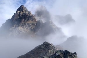
Ordesa is Spain's oldest National Park and a UNESCO world heritage site. Here, glaciers and rivers have carved kilometre-deep canyons into the soft limestone of the area - Ordesa, Añisclo and Pineta. These three plunging canyons are topped by a string of 3000 metre peaks. The highest, Monte Perdido (3355m), is a popular goal for hikers and gives spectacular views across the range and down into the canyons below. Nature lovers are in for a treat too, as the park has superb flora and birds of prey.

© ali k
The Ordesa Valley has the most hiking options. There's something for everyone here with gentle walks in the valley floor through to narrow ledges perched high in the cliffs. The four classic day hikes in the valley are the Valley floor to Circo de Soasa, the Faja Racon, The Faja de Pelay and the Faja de las Flores. These all start from La Pradera where you can park in low season. From mid-June to mid-September a shuttle bus operates from the nearby village of Torla. This runs quite efficiently every 20 minutes and costs 4.50 euros return.
The Faja de Pelay is one of the best walks in the park. It starts with an initial steep 600m climb up the southern cliffs. This ascent - particularly in August - is best made early in the morning when the path is in shade. At the top you'll be rewarded with fantastic views along the valley and across to the border peaks. From here the path is sheer joy as it contours around a wide ledge along the full length of the valley. As you reach the head of the valley the path gently drops to the valley floor and you follow the main path back to the Pradera. Start early and allow yourself eight hours for the walk - it can be done in less but you'll want time to appreciate the views on the way round.

© ali k
The Faja de las Flores is the toughest and most spectacular path. A steep thousand metre ascent takes you to a narrow ledge that contours for almost 6 km along the cliffs. You need a good head for heights to say the least! The normal descent is via the Circo de Cotatuero by a very exposed set of pitons (clavijas). It's advised to use at the minimum a sling for security, or better a via ferrata set.
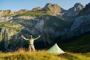
Refugio Goriz is the only hut in the park and the place to base yourself for any of the high peaks - it's got a beautiful location and great atmosphere but pretty basic dorms and toilet facilities. The refugio serves breakfasts and evening meals, and provides packed lunches. You can book nights at Refugio Goriz online - reservations are essential in mid summer when the hut gets really busy. Camping is allowed at 2200 metres and above in Ordesa but the lack of water sources mean most people end up camping outside the refugio (which is permitted). If camping you can still order meals in the Refugio if you wish.
The village of Torla is known as the gateway to Ordesa and is the best place to stay if visiting the Ordesa Valley. There's a good selection of hotels, campsites and apartments in the village.

© Hike Pyrenees Ltd
Monte Perdido (3355m)
The highest summit in the park and the third highest in the Pyrenees. The normal route is from Refugio Goriz up to Lago Helado where you turn south east to the summit. Without snow the route poses no particular difficulties and has an alpine grade of Facile (F). However the route is steep, the path not always clear and it can be tricky in poor visibility or bad weather. The section after Lago Helado, called La Escupidera (the spittoon), is the steepest. Often icy or snowy, a slip here would be serious so check conditions at the refugio and take crampons and ice axe if necessary. The ascent takes between 4-5 hrs with 3 hrs to descend back to the Refugio. Monte Perdido can also be climbed by its northern face from the Pineta Valley. This is a more technical route and usually requires a night in a bivvy or tent on the Balcon de Pineta.

© James Rushforth, May 2013
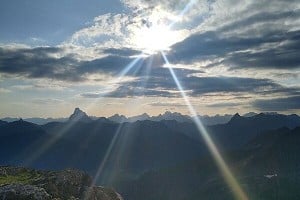
Brecha de Rolando (Breche de Roland)
This 70 metre deep cleft in the border cliffs is the best place to cross to France and Gavarnie. Legend has it that this incredible pass was created when the Christian general Roland fled from the Moors after his army was ambushed - he cleaved the Brecha with his sword to escape to safety in France. You can do the Brecha in a day but I think its much better taken in as a two or three day route combined with a stay in Refugio Goriz. The ascent from Goriz up to the Brecha is straightforward when there is no snow. There are two routes, one ascending from the south and the other that skirts under the cliffs of El Casco crossing Paso de los Sarrios - a set of straightforward chains (avoid these in snow).
The Brecha is at 2807m and can keep its snow until quite late in the summer especially on the French side where there is a small glacier. Check conditions and make sure you are properly equipped before committing to a route between Spain and France.

© Hike Pyrenees Ltd |

© Hike Pyrenees Ltd |
Fast Facts
Snow conditions on higher peaks
On Monte Perdido, the Brecha and other 3000 metre summits crampons may be needed at any time of the year. In an average year I'd definitely expect to use them up to mid-July but it's not unheard of to still need them all through the season and there's always the chance of a cold snap even in August. Check on conditions and equip yourself accordingly. The Refugio Goriz Facebook page is a great place to check conditions and they regularly post updates on which routes need crampons. Be aware of avalanche risk especially spring/early summer on south facing slopes on hot days.
When to hike
The deep canyons means snow sticks to the paths until quite late which is dangerous on the narrow Faja paths. People often make the mistake of planning a trip too early. The Faja de Pelay and Faja de las Flores usually open the second or third week of June. Before then day hiking is mainly limited to the valley floor. From mid July to late August Ordesa gets quite busy although head away from the main paths and you'll still find plenty of quiet spots. Hiking is usually possible until mid October after which you need to be prepared for snow on any of the higher paths.
Maps
Maps are easy to buy in Torla and most hotels sell them too. Editorial Alpina cover the park in a single 1:40,000 sheet or a pack of two 1:25,000 sheets. I like these maps - they're quite clear maps and the main paths are shown fairly accurately (for Spain!). If you're heading to the higher peaks the SUA Ediziok publish an excellent series of 1:15,000 maps and this extra detail is helpful for navigating where the paths aren't clear. No. 5: Monte Perdido covers the park and gives some good route suggestions (in Spanish).

© ali k, Jul 2011
Who's Writing?
Phil James is an International Mountain Leader. His passions are the mountains, culture and wildlife of the Spanish Pyrenees, where he's lived and worked for the past seven years running Hike Pyrenees with his wife Anna.


Comments