National Parks Without the Crowds: Lake District

© Chris Scaife

With an estimated 15.8 million annual visitors, the Lake District is one of the most popular National Parks in the UK. This year, with the country in the grip of a staycation boom, it's likely to be busier than ever in core parts of the park. When vast numbers of people congrete in a small space, there will inevitably be problems. In the major tourist centres and best-known valleys, expect congested roads, overflowing car parks, bustling lake shores, teeming trails, noise, and litter. If you visit at the height of high season, you'll be adding to the mayhem no matter how responsibly you behave!

Head east and you might have the fells (almost) to yourself  © Chris Scaife
Head east and you might have the fells (almost) to yourself
© Chris Scaife

For many walkers, escaping the crowds is not just a response to disease transmission advice – it's a way of life. Unfortunately, the usual experience on the most popular Lakeland walks in the high season is that you spend a large part of your day stuck in traffic, struggle to find a space in a crowded car park, and then follow a line of people up to a thronged summit. But the Lake District is a big place, with many lesser-known corners that lend themselves to social distancing and a more laid-back walking experience.

Peace, quiet, and wide open spaces are the norm in the far northern fells  © Dan Bailey
Peace, quiet, and wide open spaces are the norm in the far northern fells
© Dan Bailey

Tourist Centres to avoid where possible

There are all sorts of reasons for visiting the Lake District, and of course not all visitors are going to be out in the fells. People also come here for the charming towns, historic sites, the bodies of water themselves, the pubs and restaurants, the shopping ... In hillwalking terms though, the area boasts all of England's highest points amid some of its finest scenery. It's really no surprise that there are so many people here.

Throughout the year, but especially during the summer, the streets of accommodation hotspots including Windermere, Ambleside, Keswick, Grasmere and Coniston are sure to be bustling with people; the roads and car parks will in all likelihood be thronged with cars. You can safely assume these areas will be at capacity for much of this year.

Across Morecambe Bay to Arnside Knott   © gsum
Across Morecambe Bay to Arnside Knott
© gsum, May 2020

There are alternatives though. Staying on the edge, or just outside, the National Park is one way to avoid the crowds. For the majority of people, this will also involve a shorter journey from home, as for the most part the margins of the Lake District

are closer to major roads and easier to reach by public transport than the more central areas. Reducing the amount of driving through the Lakes, of course, also cuts down on pollution. For alternative bases that may be a notch or too less frantic, look at towns and villages close to the park boundary, such as Cockermouth, Penrith, Shap, Kendal, Sedbergh, Arnside, or Grange-over-Sands.

Wall-to-wall in Wasdale, bustling in Borrowdale

The most famous valleys in the high fells are as likely as the visitor centres to be mobbed this spring and summer, so expect a fraught parking situation in Langdale, Wasdale and Borrowdale, among others. If you can avoid starting a walk in these more obvious valleys, you might have a more relaxing day.

Parking nightmare in Wasdale  © National Trust
Parking nightmare in Wasdale
© National Trust

Lakeland Walks to beat the bustle

Back o' Skiddaw

The northernmost sizeable Lakeland peaks are marked on the Ordnance Survey map as the Uldale Fells and the Caldbeck Fells. In this barren landscape to the north of Skiddaw – hence the more appealing name, Back o' Skiddaw – there are numerous summits well worth a visit, whether bagging 2,000-foot peaks or just seeking solitude in the great outdoors. These are mostly rolling, grassy hills that lack the dramatic rocky ridges of their other celebrated southern neighbour Blencathra, but the appeal here lies in their remote nature. It is entirely feasible that several days could be spent in this corner of the Lakes without encountering another soul.

A visit to the Back o' Skiddaw will normally not involve much driving through the National Park. Walks can be started from parking spots near Caldbeck, Hesket Newmarket or Mosedale – all of which are within half an hour's drive of the M6. There are accommodation options in many of the villages dotted around this northern fringe of the Lake District. This is suitable for wild camping (more on the legalities of that here) and there is a small bothy near the summit of Great Lingy Hill – so there's really no need to rush off home.

Heading up Mungrisdale Common towards Blencathra, with Skiddaw's quieter side in the background  © Rob Greenwood
Heading up Mungrisdale Common towards Blencathra, with Skiddaw's quieter side in the background
© Rob Greenwood

The "classic" fell walk, if such a thing exists around here, is a circuit of the 2,000-foot peaks. This can be started from Poddy Gill, at the end of the road that runs west beside the River Caldew from the hamlet of Mosedale. However, a more adventurous starting place is from Britain's highest hostel, Skiddaw House. This off-grid hostel is beside the Cumbria Way, three and a half miles from the nearest road, and is currently open for exclusive hire only, although when Covid restrictions are lifted it will again offer private rooms, dormitories and camping.

Skiddaw from the Northeast  © Dan Bailey
Skiddaw from the Northeast
© Dan Bailey

The obvious track along the Cumbria Way can be followed north-east from the hostel to Poddy Gill, the parking spot for day trippers. It is then a straightforward ascent to the summit of Carrock Fell, which is encircled by the foundations of an Iron Age fort. The geology here is highly unusual, with many rare minerals present, including large amounts of gabbro – the predominant rock in the Black Cuillin, which can lead to unreliable compass readings. The clear path west leads to Hare Stones, with a detour to High Pike to enjoy unobstructed views north to the Solway Firth and the Southern Uplands. After stomping across the heather to Great Lingy Hill, it is worth visiting the small, timber bothy Great Lingy Hut (but please note, all MBA bothies are currently closed, what with the Covid restrictions), before proceeding over the remote summits of Knott, Little Calva and Great Calva. A small path leading down south-west from the summit of Great Calva joins the Cumbria Way at a footbridge over the immature River Caldew.

Here are some shorter routes in this quiet area:

And this is the biggie, the Old Crown Round, which takes in all the major summits in the northern fells including Skiddaw, Blencathra, Great Calva, Carrock Fell, Bowscale Fell and Knott:

Mosedale and the Sleddale Fells

Many walkers visit Shap only once in their lives, passing through it and perhaps staying overnight on the Coast to Coast Walk. However, with the A6 running through the centre and the M6 nearby, it is a convenient place to reach by car and makes an excellent base for the Far Eastern Fells. Swindale Head is a short drive, or cycle, from Shap, and is the starting point for a lonely wander around Lakeland's easternmost 2,000-foot peaks.

Longsleddale and Tarn Crag from Kentmere Pike  © Chris Scaife
Longsleddale and Tarn Crag from Kentmere Pike
© Chris Scaife

These fells have much in common with the Back o' Skiddaw, in that they are more green and rolling than savage and rocky; any stop-and-think moments are likely to be working out ways around boggy patches rather than technical scrambling, and crowds are usually conspicuous by their absence. This area is home to the largest MBA bothy in the Lake District – Mosedale Cottage – and more varied wildlife than most Lakeland fells, including a sizeable red deer population. There is little chance of an adrenaline rush around here, but much to satisfy those with an appreciation of the wild and remote parts of the land.

The walk up towards secluded Mosedale from Swindale Head is a visual delight, with burgeoning woodland, broken crags, and streams cascading down gullies on either side of the path. Mosedale itself is a quagmire after heavy rain, but with careful footwork you'll soon be at the bothy. The route up to Harrop Pike is pathless and untamed; this is the realm of the stag, not of the sheep.

The adjacent Sleddale Fell tops – Grey Crag and Tarn Crag – are an easy stroll from Harrop Pike. In these parts it can feel as if the whole world is a range of hills, with views in every direction dominated by the peaks of the Lakes, Pennines and Yorkshire Dales. A fence running across the summits now makes navigation a doddle as you drop down to the head of Mosedale and then walk up to the flat top of Branstree. If reaching high points is your raison d'être, leave the fence line to visit Branstree North East Top en route to Selside Pike, with its ancient cairn. Now descend northwards to join the Old Corpse Road and, with or without a coffin on your shoulder, follow this back to Swindale Head.

Whinfell Common and Whinash Ridge

In the far east of the Lake District there is a line of hills so perfectly shaped and evenly spaced that if an artist painted them most people would probably assume they had made them up. Part of the East extension area added to the National Park in August 2016, these hills have remained under the radar for many visitors to the Lakes. They are hardly Munros – the highest altitude you'll reach around here is the trig point on Grayrigg Forest at 494m – but a number of tops can be visited in a day, so you'll experience plenty of up and down.

The Whinash Ridge near Borrowdale  © Chris Scaife
The Whinash Ridge near Borrowdale
© Chris Scaife

Their position, just a few kilometres west of the M6, makes them some of the most accessible hills in the Lake District - but not a lot of people seem to know that. If travelling by car, the best place to start your walk is a small parking area on the road that goes a short distance up Low Borrowdale, not far south of everyone's favourite motorway services at Tebay. Perhaps the most gratifying approach, though, is to cycle in from the south-west, as the bridleway heading up to the Whinfell Ridge from Tarnside is paved all the way and involves well over 200m of ascent.

The Whinfell Ridge is an under-appreciated gem on the park's eastern fringes  © Chris Scaife
The Whinfell Ridge is an under-appreciated gem on the park's eastern fringes
© Chris Scaife

A walk along the undulating Whinfell Ridge – taking in the summits of Grayrigg Pike, Grayrigg Forest, Whinfell Beacon, Castle Fell, Mabbin Crag and Ashstead Fell – has a wild feel to it, in spite of its proximity to the M6. It's an obvious ridge, where paths are sometimes faint and the best form of navigation on a clear day is to head to the highest point, then look around for the next one and walk to that. From the western end of the ridge, you can either walk back along a big track through the valley or head up Breasthigh Road and take in another long line of peaks – Greenside Crag, Whinash, Winterscleugh, Roundthwaite Common, Belt Howe, Casterfell Hill and Jeffrey's Mount.

Kentmere Pike from Kendal

Kentmere Pike is one of a handful of 2,000-foot summits that can be reached by long day walks from Kendal. This is a town with ample transport links – as well as being close to the M6, there is a bus station in the town centre and a railway station with hourly trains between Windermere and Oxenholme, which is on the West Coast Main Line. Another plus is that accommodation here is less likely to be booked far in advance than in the major tourist honeypots of the Lake District.

Longsleddale from the Gatescarth Pass descent  © Chris Scaife
Longsleddale from the Gatescarth Pass descent
© Chris Scaife

A grand day out, starting from Kendal, begins with a walk beside the River Kent as far as the Woodland Trust reserve at Beckmickle Ing, then follows a distinct bridleway across Green Quarter Fell. This big patch of open moorland sits between Kentmere and Longsleddale and, despite being within walking distance of both Windermere and Kendal, you'll not see many people here.

The rewarding summit of Kentmere Pike is within reach, followed by a completely off-piste descent to Gatescarth Pass, then a long, long walk through Longsleddale. This is the quintessential peaceful Lakeland valley, where traditional farms are interspersed with patches of woodland. The ridges on either side become progressively less rugged as you approach Kendal.

Sca Fell and Scafell Pike the quiet way

Sticking to the peripheries of the National Park is a great way to reduce congestion and cut down on driving, but of course there are some iconic fells near the centre of the Lakes that we all want to visit. There are numerous options for an ascent of Scafell Pike, the highest mountain in England. Many of these routes showcase some of the finest upland terrain in the land, while certain others – the shortest approach from Wasdale Head, for instance – are often too crowded to be enjoyable.

The Scafells and Upper Eskdale  © Lankyman
The Scafells and Upper Eskdale
© Lankyman, Oct 2020

For a quiet walk in, my personal favourite route begins near Cockley Beck. This hamlet is in an oasis of calm between the white-knuckle mountain roads over Hardknott and Wrynose Pass, so if travelling to the start by bike from either Eskdale or Little Langdale you can test yourself on the King or Queen of England's cycling hill climbs. But if you'd rather avoid that, Cockley Beck is also accessible from the Duddon Valley road. A clear bridleway heads north up Moasdale and from the head of this valley England's two highest mountains make an imposing sight to the north-west. From Moasdale, the faint path across Lingcove Beck, past rocky buttresses and on to the squelchy Great Moss can feel more like a remote part of the Cairngorms than an approach to such a popular Lakeland peak.

On the way up Scafell Pike from Great Moss: crowds conspicuously absent on this side of the hill!  © Chris Scaife
On the way up Scafell Pike from Great Moss: crowds conspicuously absent on this side of the hill!
© Chris Scaife

After ascending past a picture-postcard waterfall by the grade 1 Cam Spout Scramble Indirect, it is worth making a detour to Symonds Knott and England's second highest mountain, Sca Fell. There's no need to worry about finding an obscure way to the top of Sca Fell – it just always seems to be quiet up there. The views on all sides are every bit as spectacular as those from Scafell Pike, and you can almost guarantee that there will be fewer people here, so make the most of those panoramas. The easiest way up and down is the narrow path that passes Foxes Tarn. Romantic poets may wish to descend by an alternative route.

From Mickledore to the top of Scafell Pike there will be crowds, but this brief dalliance with the hordes is a small price to pay for the satisfaction of reaching the highest point in England. A steep descent on scree down to Little Narrowcove will soon whisk you back to tranquillity, and then you can return across Great Moss and back down Moasdale.

Helvellyn from Thirlspot

I imagine I'm not alone in this regard, but I have a real love-hate relationship with Helvellyn. It's a majestic peak that can be summitted by one of Lakeland's classic scrambles – Striding Edge to Helvellyn to Swirral Edge, or vice versa – and with clear skies the views all around are breathtaking. However, on weekends and during school holidays, there can be large crowds on the most popular routes from Glenridding, Patterdale and from the nearest car parks beside Thirlmere. At these times, it is not uncommon for bottlenecks to form on the narrow ridges of Striding Edge and Swirral Edge. And who wants to queue to climb a mountain?

Ascending Helvellyn from Thirlspot, a quieter take on a heavily-trodden fell  © Chris Scaife
Ascending Helvellyn from Thirlspot, a quieter take on a heavily-trodden fell
© Chris Scaife

Thankfully, there are also comparatively quiet routes to the summit. A quality mountain day that will feel wilder than most Helvellyn ascents begins on the bridleway that leads uphill at the back of the King's Head Inn at Thirlspot. This inn is one of the stops for the 555 bus, which runs hourly between Lancaster and Keswick, stopping at – amongst other places – Carnforth, Milnthorpe, Kendal, Windermere railway station, Ambleside and Grasmere. So, whether travelling from afar by train or from accommodation in the Lake District, the car can be left at home.

There are several options from here, but to avoid the tourist route as much as possible the ascent via Brown Crag and White Side takes some beating. A steep, grassy path past the impressive waterfalls in Fisherplace Gill leads up to Brown Crag, followed by a gentle continuation to the cairn atop White Side. This is a desolate moor in comparison to the usual approaches to Helvellyn.

From White Side, quickly nip south on an easy path to Lower Man and then jostle your way to the summit of Helvellyn, before returning to the serenity of the ridge back to White Side. A clear rocky track along the ridge can be followed north-east over Raise as far as Sticks Pass, where a westward descent leads to a progressively steeper grassy path back towards Thirlmere. A footpath on the left, above the hamlet of Stanah, completes the loop back to Thirlspot.

Alternatives on the busy hills

There are six day-walks described above, but in many ways the opportunities for quiet fell walks in the Lake District are endless. Even when the shortest routes up the best-known peaks are teeming with people, the less obvious routes tend to be comparatively empty. Starting before dawn, or in the evening, will almost always mean fewer people are about. And a bit of imagination should allow you to plan all manner of wonderful esoteric days out in the hills.

Casting a lonely shadow on the way up Kentmere Pike  © Chris Scaife
Casting a lonely shadow on the way up Kentmere Pike
© Chris Scaife

Scrambling

Scrambles add spice to any day in the outdoors and apart from one or two classics – e.g. Jack's Rake and Striding Edge – will usually be reasonably quiet. The new Cicerone guides Scrambles in the Lake District – North and Scrambles in the Lake District – South detail about two hundred routes, most of which you are likely to have to yourself.

Public Transport

Everyone knows that cutting down on our driving is beneficial for the environment. And reaching the start of a walk by public transport – or, even better, cycling – can make the whole trip seem so much more adventurous, as well as removing the hassle of driving and parking, and easing congestion in the National Park.

The West Coast Main Line, the rail service between London and Glasgow, runs along the eastern edge of the Lake District, close to the M6, with stops at Oxenholme (near Kendal), Penrith and Carlisle. There is also a direct train between Manchester and Windermere, with stops at Kendal, Burneside and Staveley. On the other side of the Lakes, the Cumbrian Coast Line connects Carlisle with Barrow-in-Furness via a plethora of stops. In addition, many of the larger places, and a good few smaller ones, are connected by regular bus services.

In fact it's perfectly possible to access any fell in the Lake District via public transport, as at least one keen Wainwright-bagger can testify:


Cycling

If you have the opportunity, cycling is perhaps the most rewarding way to travel around. The Lake District is a cycling venue of international importance, with miles and miles of roads through spectacular scenery. There are some seriously challenging mountain passes, such as Hardknott, Wrynose and Kirkstone, but also numerous more sedate options. If you don't know the area well, the best way to avoid traffic on a road bike is often to follow part of a waymarked cycle route, such as the C2C or the Lakes and Dales Loop. These routes have been carefully plotted to follow quiet country lanes for most of their length.

The mountain biking trail centres at Whinlatter Forest and Grizedale each have trails suitable for riders of all abilities. But to escape the crowds, head for the hills. There are bridleways all over the place, with some exceptional natural trails just waiting to be found by the adventurous rider.

Responsible access

Traffic, crowds and litter are likely to make headlines this year. Make sure you're not part of the problem in the Lake District by parking responsibly, lighting no fires, avoiding roadside fly camping and abiding by the Countryside Code:


Well. Yesterday I was made aware by several pals, of a right old horrible mess down at Thirlmere. I've been down there...

Posted by The Lakes Plastic Collective on Sunday, 28 March 2021

Social Distancing

The lockdowns have been hard for us all. As restrictions ease, it is a real pleasure to be able to see friends and family again, to socialise with the people we care about. But in the great outdoors, I'm sure I'm not alone in preferring quietude, where other wayfarers are a rare sight and all have a tale to tell.


6 May, 2021

"we suggest some quieter alternatives": will be less quiet now this articles been published. There was an article in the Times last Saturday "UK's 50 quietest beaches": not any more...

People will come to the area anyway, in their millions. But even in somewhere as small and busy as the Lakes the footfall does tend to concentrate in certain areas. The idea of this series is to help spread the load and encourage a mindset of looking beyond the usual honeypots. I doubt the Shap fells will be heaving as a result of this article, but the comparative few people who read it (out of those millions) might appreciate a few pointers to escape the hordes.

6 May, 2021

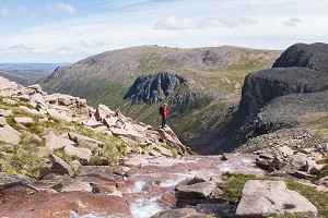
You've included a photo of the wrong Grey Crag, the one in the pic is the one near Hayeswater not the one at Sleddale.

Thanks! I was trying to make that photo fit the map, and had myself convinced. No excuses, from someone who lived in Patterdale for a while

6 May, 2021

I've got some photos of the right one from a backpacking trip last year if that would help. It's not very interesting though! Tarn Crag nearby is better with a very distinctive cairn.

More Comments
Loading Notifications...
Facebook Twitter Copy Email