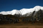
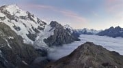
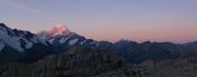
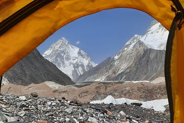
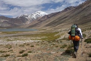
How Hard is New Zealand's 3000km Te Araroa Trail?

© Katrina Megget

Running the length of New Zealand from end to end, the Te Araroa (TA) Trail officially opened in 2011 and has seen a steady increase in walker numbers over the years. Perhaps unsurprisingly, it's gained a reputation for being challenging - but it also looks fantastic. Katrina Megget offers the lowdown on this classic Kiwi mega-tramp, and advice on gear and logistics.


New Zealand is where I was born and raised and it will always be home, even though I've spent the past 14 years living in the UK. It's because of this that the idea of walking the length of my home country has always appealed to me.

The trail boasts remote river valleys...  © Katrina Megget
The trail boasts remote river valleys...
© Katrina Megget

The Te Araroa Trail was officially opened in 2011, and in trail terms it's still considered new and some sections are still under development. About 14% of the trail is road walking with around 40% going over private land, which requires negotiations for through-access with landowners, councils and local indigenous Maori tribes. It means the trail can be brutal and unforgiving; it has a reputation for both mud and road walking. But, weirdly, this is all part of its charm.

...lush forests...  © Katrina Megget
...lush forests...
© Katrina Megget

This was my first long distance trail, and it won't be my last. But it was something of a baptism of fire to long distance walking.

Trail stats

Distance: 3000km

Heading south: Starts at Cape Reinga and finishes in Bluff

Takes: Four to six months

Average walking speed: About 2.5km/hour

Estimated number of through hikers each season: About 2000

Cost for a through-hike: NZ$7,000-$10,000 (£3,500-£5,000)

Highest point: Stag Saddle at 1,925m

Number of river crossings: Several hundred

Non-walking days: Six days kayaking, one day cycling

Longest section between resupply points: Nine days

Worst mud: Raetea Forest

Number of blisters: 12 (at the same time) after two weeks

...and wide open spaces  © Katrina Megget
...and wide open spaces
© Katrina Megget

Why do it?

I might be biased but New Zealand is stunning. It's known for its thick, green native forests, jagged peaks, golden sand beaches, 'clean green' image, friendly people, interesting bird life and excellent meat pies.

What Te Araroa offers is a snapshot view, at walking pace, of the best of New Zealand. It jumbles the bustling cities, sleepy beachside settlements, muddy forests and volcanic landscapes of the North Island with the remoteness, mountains and vast open spaces of the South Island. It's a trail that is unique in bringing people and place together, which is what sets it apart from other long-distance trails.

Many people choose to only walk the South Island where the "proper" mountains are, but this is almost a disservice to the full trail and misses the numerous highlights of the North Island, including the town and country culture of New Zealand.

One of the particular advantages of this trail is that New Zealand has no bears, mountain lions, snakes, poisonous insects or insect-borne diseases, meaning there is one less thing to worry about.

Deception Track  © Katrina Megget
Deception Track
© Katrina Megget

New Zealanders have coined the word tramping, which I like to define as extreme hiking. The Te Araroa Trail gives the hiker a proper taste of what this means

When to go and how long will it take

A through-hike of the Te Araroa trail will take four to six months depending on walking speed, distance covered each day (some walkers clock 50km days – on good tracks – once their trail legs kick in), whether you decide to hitchhike or miss sections, possible injuries and weather conditions. The Te Araroa Trust suggests 50-80 days per island. In recent years, fast hikers have completed the trail in 100 days.

In general, the summer tramping season in New Zealand starts in late October and it's advised, if heading southbound (SOBO), to leave Cape Reinga before January and aim to reach Bluff before the end of April. Increasing numbers of walkers start the trail in September – often to avoid getting stuck in a large bubble of walkers – but they run the risk of heavy spring rain and track closures in September and October due to farming and forestry operations. If heading northbound (NOBO), most people leave Bluff between November and the end of January.

I headed southbound from Cape Reinga on November 5th 2018 and crashed out early in the South Island in early March 2019 due to a knee injury I picked up on the steep slopes of the Richmond Ranges. As it was, it would have been unwise to continue had my injury recovered because the seasons were already starting to change and I still had 1,000km left to walk. I was clearly a slow walker and took a lot of rest days. I returned in January 2020 to complete the South Island and was on schedule to reach Bluff by the end of March but New Zealand's Covid-19 lockdown hit seven days before finishing, putting an end to the walk.

Determining the best place to cross a river  © Katrina Megget
Determining the best place to cross a river
© Katrina Megget

SOBO or NOBO?

The trail can be walked either northbound or southbound, but the traditional route is southbound with the trail description and notes in this format. But there are increasing numbers of walkers choosing to walk northbound mainly because they will likely encounter fewer walkers and get stuck in fewer walker bubbles. Some people also think northbound is harder because of some of the tracks and because the trail notes northbound are incomplete, and so it presents more of a challenge.

What to expect

The Te Araroa trail is diverse and potential walkers should expect beach walking, road walking, exceptionally muddy native forests, traversing bustling cities, climbing active volcanoes, crossing farms with paddocks of bulls, six days canoeing down a river, majestic mountain trails, and crossing tidal estuaries and more than 200 rivers.

Expect plenty of deep mud!  © Katrina Megget
Expect plenty of deep mud!
© Katrina Megget

Some of the trails, particularly those in the North Island, are in poor condition and even borderline dangerous. There are not always trail markers so sometimes navigation can be difficult, while several tracks are exceptionally steep, both for ascent and descent. Many are also exposed and weather dependent. Throughout the course of the trail hikers can find themselves walking on golden sand, through knee-high mud, on fluid scree, wading up rivers, boulder-hopping, scrambling on all fours over rocks, pavement pounding, and treading on seemingly non-existent paths, as well as kayaking, canoeing and cycling. For the most part, this isn't a walk in a park – though there are several tracks through parks and other paths that are of good quality. New Zealanders have coined the word tramping, which I like to define as extreme hiking – the Te Araroa Trail gives the hiker a proper taste of what this means.

How it compares to other long-distance walking trails

While I haven't walked any other long-distance trails, I met a heap of people on the TA who had, namely the big trails in the US, the Pacific Crest Trail and the Appalachian Trail. The vast majority of these walkers were surprised by the Te Araroa, especially the North Island section. They were surprised by the amount of road walking, the amount of mud, the poor quality of the tracks, the inability to just wild camp anywhere, and surprised by the number of towns the trail led us through. They expected the Te Araroa trail to be exactly like the PCT and AT with their "easy" well-maintained paths, excellent signposting for navigation, strong volunteer networks, and wilderness.

The Te Araroa Trail is different, and that unique character is part of its beauty and part of the challenge in walking it. Walkers should not assume the Te Araroa is just another long-distance trail, and it should be thoroughly researched before attempting it.

Highlights from the trail

Some of my highlights include: humbling giant native kauri trees; stunning west-coast sunsets; the rich, sweet-sounding bird life; golden sand beaches; cloud-inversions; amazing trail angels; the Whanganui River canoe journey; the Tararua goblin forest; the Queen Charlotte Track; epic ridgelines; emerald-blue and turquoise lakes; breathtaking mountain vistas; wild swims; the southern hemisphere night sky; and the amazing sense of space and freedom.

So, how hard is it?

This is what is written on the Te Araroa Trail website: "Tramping many of the Te Araroa's tracks requires the bush craft skills of an experienced backcountry tramper. These skills include trip planning, navigation, and river crossing skills, all of which are prerequisites to good decision making and capability in the field. You also need to know what survival equipment to carry and how to avoid getting hypothermia… A moderate level of fitness is all that is required to make a realistic attempt at a through-tramp."

Some of the river crossings can be challenging and potentially dangerous  © Katrina Megget
Some of the river crossings can be challenging and potentially dangerous
© Katrina Megget

For a first long-distance walk, the Te Araroa Trail is hard, especially as you're still learning about your kit, your body and your food requirements. Of course, as one NOBO walker I met said, hard is relative – some people will find the trail and the terrain harder than others.

The best word to describe the trail is demanding. It's the one word most commonly used in conversations. The quality of many of the tracks makes the going challenging, and many people get frustrated at the slow walking pace they are forced to take. Meanwhile, the road walking is monotonous and frustrating. Logistics can be a nightmare too, making decision-making challenging and forcing hikers to walk longer distances than they might like just to get to the next accommodation point. For example, you should only camp at the designated campsites on Ninety Mile Beach, the very first section of the trail SOBO, which means on day two of the walk you have to cover 28km and on day three, 30km – making it a rude introduction to the trail.

Some parts can be exposed!  © Katrina Megget
Some parts can be exposed!
© Katrina Megget

There are also sections that are more dangerous, like the lack of signage in the muddy Raetea Forest. Two weeks before I did this section, a German girl got lost in the forest and fell off a waterfall at 9pm and was forced to call for search and rescue. The Mangaokewa River path is barely a foot wide and in poor quality, traversing high above a river. A girl I met tripped off the track and fell two metres. She was only able to get back on the track due to having a walking companion that day. There are numerous steep ascents and descents that are exposed. I injured my knee on one. I met one girl who fell and gave herself a concussion on another. And in 2013, a TA walker died approaching the second-highest point on the trail. But on all these sections, like any hillwalking, common sense is paramount – check the weather, walk in a group, let people know your intentions, and carry safety equipment and adequate safety communication devices.

For me, the trail was both physically and mentally demanding. I spent most of my walking time thinking about how much pain I was in and focussing intently on foot placements so I didn't slip or fall over.

The general rule is that the first two weeks are the hardest – four to five days walking down a monotonous beach followed by a week of muddy forests. A statistic I heard was that 30% of walkers drop out after the first two weeks. The saying goes that if you can do the first two weeks, you can do the whole trail.

That said, the walkers I met were all ordinary people. Some had walked other long distance trails, but for others, the TA was their first. Some were in their 60s, some were overweight, some had knee injuries, some were smokers, some carried 25kg on their backs. All of them walked the trail their own way. Anyone can do this if you're prepared and have the right mental attitude.

There's a lot of rough, remote country - like here in the Nelson Lakes area  © Katrina Megget
There's a lot of rough, remote country - like here in the Nelson Lakes area
© Katrina Megget

Training

The TA Trust, which manages the trail, recommends that walkers consider a backcountry/bushcraft survival course, especially a river crossing course. Death from crossing rivers is one of the top contributors to deaths in the New Zealand backcountry. I did a river crossing course in the Lake District before I left for New Zealand. I also brushed up on my navigating and map reading. I also did a kayaking course to prepare myself for the kayaking sections that can be done. Obviously, fitness training, namely hillwalking with a heavy pack, should be considered.

The TA website lists safety courses, while New Zealand's Department of Conservation has a brochure on planning backcountry trips here.

Navigation

Navigation on the trail can be pretty sketchy in places. As a general rule, the trail is signposted with orange triangles or orange snow poles but these are not always at regular distances and can sometimes be hard to see. Sometimes there is no signage at all. The quality of the tracks is variable, and sometimes questionable, and it's not always the case that there will be a path present.

This makes navigating interesting at times. The TA Trust supplies trail notes and maps on its website which can be downloaded to your smartphone (although I met two walkers – both French – who had printed out all the trail notes and were carrying them in giant ring binders). These are updated annually in early September to take into account any track changes or closures.

The trail notes are detailed but better for logistics planning than navigating. The maps in 1:50,000 scale are helpful for the road walking sections but are a bit harder to navigate off for the other trail sections. Most walkers use a GPS app on their phone, with Guthook being the most common, although the TA Trust introduced its own trail app last season, which seemed to get pretty good reviews from the people I spoke to who were using it.

The official guidebook (which I did see some walkers carry – and use as toilet paper) is Te Araroa: A Walking Guide to New Zealand's Long Trail.

Canoeing on the Whanganui River adds an unusual nautical element to the TA  © Katrina Megget
Canoeing on the Whanganui River adds an unusual nautical element to the TA
© Katrina Megget

Logistics

As a general rule, around 80% of the North Island is camping (or tenting as Kiwi's call it) at designated campsites or holiday parks, while about 80% of the South Island is in backcountry huts. The backcountry huts are old huts often set up for hunters or musterers decades ago. Mostly corrugated iron, they can be draughty and are home to legions of mice and rats. They consist of a fireplace, a cooking bench and sleeping bunks. There is a long-drop toilet, without toilet paper, some walk away. Some of the huts only sleep six people, meaning walkers will still need to carry a tent in case huts are full, which is becoming increasingly common. Buying a backcountry hut pass from the Department of Conservation will be needed.

Logistics and planning each day's point A to point B walk can be challenging in places, particularly on the North Island. The trail notes list accommodation options at section start and end points and en route, but the distances can vary so it's difficult to walk the same amount each day. This is further complicated by the fact that 40% of the trail is on private land where wild camping is not allowed – in recent years some walkers have ignored this, which puts future trail access across these lands in jeopardy. Increasingly, however, as the trail has become more popular, more trail angels have popped up to help with logistics and provide accommodation. They now have a dedicated website.

There are other logistic nightmares to consider as well including tide times for estuary crossings, crossing the Whangarei Harbour, booking shuttles to get around the two danger zones in the South Island (the Rakaia River and the Rangitata River), booking the Whanganui canoe journey and juggling weather events. Information on these areas are in the TA Trust trail notes.

While there is no permit or fee needed to walk the trail, a permit is required to walk the Queen Charlotte Track at the top of the South Island. Meanwhile, a donation to the TA Trust of NZ$250 per Island walked is recommended to ensure maintenance and management of the trail.

Climbing towards Waiau Pass  © Katrina Megget
Climbing towards Waiau Pass
© Katrina Megget

Food and resupply

In the North Island, food and resupply isn't a big problem because of the towns regularly walked through. But the South Island is a different matter, being more remote. The longest stretch between resupply points is the Richmond Ranges, at the top of the South Island, which can take nine to 11 days, though it's recommended to carry food for another two days in case bad weather forces a stay in a hut for several days.

In addition, a resupply box needs to be sent to St Arnaud at the end of the section because there is no adequate resupply shop. Further resupply boxes, if walkers are not looking to hitchhike out to towns, need to be sent to Boyle Village and Arthur's Pass. Details about where to post to are in the trail notes but these need to be posted ahead of starting the South Island section. Further south, resupply will need a hitchhike or road walk to the nearest town unless a local trail angel is storing resupply boxes.

During the walk I mostly ate my mother's green super muesli (powered by spirulina) for breakfast, peanut butter or cheese wraps for lunch and a dehydrated meal for dinner alongside numerous snacks and a lot of chocolate. I saw a variety of weird food combinations – soaked lentils and grains with vegetable stock broth, cold-soaked couscous, fried Chinese noodle snacks with peanut butter in wraps, cold garlic and tomato paste, butter mixed with peanut butter. Keeping food as lightweight as possible but being calorific is the prerogative.

South Island is a land of lakes  © Katrina Megget
South Island is a land of lakes
© Katrina Megget

Water

Despite New Zealand's clean, green image and its sparkling clear river waters, New Zealand has a nasty secret – a lot of its waterways are actually highly polluted. This is mainly a result of agriculture with farming runoff. I met a lot of walkers who weren't carrying water treatment means to save weight and because they believed New Zealand river water was safe to drink. Technically, high in the mountains, the water "could" be safe to drink but you can't guarantee clean water and there are some sections with no adequate water sources. Furthermore, the water tanks at huts can be contaminated with possum droppings or dead rats.

For my first attempt at the trail, I used the MSR Trailshot Micro water filter. However, this was impractical when I needed to treat water collected from a tap and because of the time taken to pump river water it increased the time sandflies had to bite and suck my blood. When I returned to complete the walk, I used the Sawyer squeeze water filtration system, which worked well. As a backup I also carried a rather heavy Steripen.

Kit

One of the most talked about topics on the trail is kit and how heavy and/or light it is. Most walkers seem to start out with too much – my pack weighed 17kg but I met people who started with 25kg. The post office in Kaitaia after the first section down Ninety Mile Beach does a roaring trade with walkers sending home extra weight they've decided not to carry.

The general theory seems to be: the lighter the kit, the faster you can walk, the more distance you can travel, and the less injury you will sustain. I met several ultra-lightweight walkers (mainly Americans), who had base weights of 6kg. But I also met walkers who were scrimping on safety equipment to keep their weight down. A German girl decided not to carry a first aid kit, countless walkers didn't have personal locator beacons. For a trail like the TA, that is rugged, remote and potentially dangerous, carrying safety kit is paramount. Equally, walkers need to carry clothing for all temperature and weather conditions. Within the space of a month I walked in temperatures in the mid-30s and also in snow and torrential rain.

Morning at Lake Constance  © Katrina Megget
Morning at Lake Constance
© Katrina Megget

Footwear

This is one of the other most talked about topics on the trail. Firstly, expect blisters – lots of them. Walking on sand, which gets into your shoes, with wet feet, because you can't escape the tide, is a recipe for blisters. By the end of the second week I had 12 blisters on my feet and was forced to take extra rest days. Everyone will give advice on how to prevent and treat blisters. Some will work, some not. In the end you will figure out what works for you but I recommend hardening your feet and breaking in your footwear before starting the walk. In the end I soaked my feet in Epsom salts for several days, popped my blisters with a sterilised needle, used an iodine solution and taped my feet.

There is some debate about the best footwear for the TA. Most people go with lightweight trail running shoes that dry quickly, based on the vast number of river crossings on the trail. The downside of trail runners is they wear out much quicker than traditional hillwalking boots. I aimed to go through three pairs of trail runners over the course of 3,000km. In the end, over the two seasons I walked the trail, I used four pairs of shoes.

End and start points

Getting to the northern start of the trail requires a bus from Auckland and then a tourist bus from either Kerikeri, Paihia or Kaitaia. Many walkers also try to hitchhike from Kaitaia.

To get to and from Bluff at the southern terminus, a bus is required again between Bluff and the bigger city Invercargill, which has plane and bus links to other cities. Again, hitchhiking to and from Bluff is also possible.


Loading Notifications...
Facebook Twitter Copy Email