


Since next year's vote on Scottish independence basically boils down to the question of what the Anglo-Scottish border actually means, we thought it was high time to publish this article by outdoor writer Ronald Turnbull. As well as dividing people and giving politicians something to do, borders make obvious lines on maps. Ronald put this one to some simple practical use - by walking it. What he found was a natural coast-to-coast route across the width of Britain; or across Scotland-and-the-rest-of-the-UK; or whatever we might call it all after 2014.
The Cheviot has switched from Scotland into England several times over the last thousand years. So it's not surprising that it's a displaced sort of place, a strange blend between the Pennines and the Scottish Highlands. Daniel Defoe, who ascended it in an overexcited state in 1726, stated that it could be seen from Roseberry Topping in the North York Moors and that it resembled Teide in the Canary Islands. Less excusably, James Logan Mack writing in 1926 thought it looked like the Jungfrau.

© Ronald Turnbull
Coming in from the west, it's 22 miles of high ridgeline from the road pass at Carter Bar. The slopes on either side are steep, above pointy little foothills, each one with its Neolithic earthworks, and beyond them the wide grey plains of the River Tweed. The ridgeline itself is a high line straight across the country. After a full day of fast, grassy, head-in-the-air sort of stroll, beige sandstone slabs are the path onto The Cheviot's top.
"120 miles of border walking, five centuries of history, and two countries entangled over miles of bog and breezy hilltop, reivers and rivers and green empty glens"
Cheviot top is brown, and boggy, and not very like Mount Teide. But the Roseberry Topping view: computer analysis says Daniel D got that spot on. Also visible are Lochnagar, Ben Lawers and Scafell Pike. Except they're not. Around the trig point is a flat, flat place of black peat and grey-black peaty water, too wide and flat for seeing anything else at all apart from the odd fence post tilted into the breeze. The previous two trig points sank without trace, and a pile of breezeblocks supports the current one against the same fate.

© Ronald Turnbull
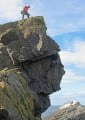
But head west among the peat pools, and those distant mountains creep up into the view. The ground flips over, and you're looking into the Hen Hole. And here's the bit that – okay, it's not the Jungfrau – but a small speck of Highland Scotland, embedded in the rounded brown surroundings.
Pretty waterfalls run down into the Hole at both corners. In the floor of the Hole, the stream runs out between granite crags. If the stream is in spate, passage may be awkward, as you cross it quite often to find the way out. The Cheviot is the literal high point of any Border walk from Gretna to Berwick on Tweed. But figuratively speaking, the walk is a succession of high points and surprises.
There's the unsuspected mud beach at the back of Gretna. Once a small port for smugglers, it's now a launchpad for windsurfers, provided they have a nice thick mudproof membrane to line the car boot afterwards. The Gretna Outlet Village is a good place to restock with socks. Or it would be if it opened earlier than 10am. I crossed the old North Road at the First and Last House and Original Marriage Room – one of three Original Marriage Rooms in the village.
"Rising out of the heather is the great Kielder Stane, where opposing horsemen would cautiously approach on the off-chance that they could settle some of their differences without actually slaughtering one another"
A roe deer bounds away among the trees. And what it's bounded over is the Scots Dyke, a low double trench beneath the leafmould. Between the rivers Esk and Sark was the Debateable Land: the last bit neither England nor Scotland, and a handy refuge for bandits of both sides. In 1552 they got the French Ambassador to divvy it up. This Scots Dyke marks that division.

© Ronald Turnbull
Young Lochinvar 'swam the Esk River, where ford there was none.' For the Border cattle thieves and those who chased them, rainswollen rivers and fords were fundamental. So it's satisfying that, where the map marks an old path leading onwards into Scotland, an unbridged and rainswollen stream crosses it. Even if it is barely knee-deep, with a comfortable silty bottom for paddling across on.
I diverted through the handsome town of Langholm as a pub and shopping stop. Behind it are steepsided, yellow-and-green Border hills, where rain flies sideways in bucketloads. A single shepherd, wrapped in layers of heavy duty nylon, gives me a pitying look from his quad bike. Fences guide down into the sudden shelter of Twislehope Hope, where rainwater drips off fresh rowan leaves, and the streams are brown and boisterous. At the bottom of it all, Hermitage Castle is the grimmest of all the Border fortresses.
 © Ronald Turnbull
 © Ronald Turnbull
Deadwater Fell has radar and radio installations, an architect-designed bike shed, and a claim of sea views on both sides of England. The 10 miles from here to Carter Bar are empty under the sun and the Spring curlews, with pools of bog water open under the sky. Rising out of the heather is the great Kielder Stane, where opposing horsemen would cautiously approach on the off-chance that they could settle some of their differences without actually slaughtering one another. It's ideal country if you're a cattle raider of the 16th Century, less so when you're walking supposedly for the fun... But there's a tiny peat path, by the Kielder Stane and the tiny Black Needle Beck, marked with ancient boundary stones. And below Carter Fell there's an old mine path, green and in places swampy, high above the head of Redesdale. At the golden end of a long tough day I came to Carter Bar, where lorries grind up out of England to cross a high skyline between the red cross of St George and the blue one of St Andrew.

© Ronald Turnbull
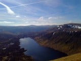
Carter Bar is just past half way. But from here it gets easier. The Border Ridge is pathed, being the Pennine Way. Then beyond the Hen Hole and the College Valley, marked paths lead out by the Till and the Tweed, a lowland stroll of glens and rivers. Instead of bogs and wild winds, the miseries of the journey now are ones from five hundred years ago. Crossing Flodden Field from the south, you reach first the Scottish battle line on the edge of Branxton Moor. The battle unfolds under your feet, as you walk through the ingenious way the Earl of Surrey led the Flower of Scotland to defeat and death. Etal is where King James lingered the night before the battle, enjoying a cream tea (and possibly other favours) from Lady Heron at the castle. It's still a place to linger, as Northumberland pretends to be the Cotswolds with a thatched pub and home baked cakes at the Lavender Café.
The sun doesn't so much set as gradually give up on the day behind a thickening horizon haze. The river and I pass under a tall railway viaduct, now abandoned. Beyond it, pale water stretches under dark branches, as the Till gently combines with the Tweed.
The Tweed is in half-darkness, and the path passes along a steep riverbank. The wood gives a choice between nettles to lie down in, and wild garlic. I go for the garlic. As I look upwards, narrow treetrunks, bare and black, converge to a vanishing point somewhere in starlight. With Berwick an easy half-day ahead, it's time to look back over 120 miles of border walking, five centuries of history, and two countries entangled over miles of bog and breezy hilltop, reivers and rivers and green empty glens.

© Ronald Turnbull

The Route
Start Gretna at Clochmabon Stone (NY312660) for paths through Springfield. Road to Sarkhall and Beckside (NY355710) to cross Scots Dike at Glenzierfoot. From Evertown, path then lane NE to track foot (NY339795). Cross Warb Law to Langholm.
Over Potholm Hill, to cross Ewes Water at Hoghill farm. N over Arkleton Hill, Pike Fell and Mid Hill to Twistlehope Hope and road to Hermitage Castle. Cross Hermitage Water at Shaws (NY508947), then over Anton Fell to Riccarton bothy (NY536976).
Old railway E to Saughtree, and vanishing old path E to Deadwater Station. Old railway SE to Kielder village.
Forest trails to Deadwater Fell. From Peel Fell, follow Border via Kielder Stane to Carter Fell, then old mine track just E to Carter Bar. Follow Border Ridge to the Cheviot. Down W inside Hen Hole to Mounthooly Bunkhouse (NT882225). N by College Burn, Westnewton, Crookhouse to West Flodden. Cross Flodden Hill to Blinkbonny, and battlefield path (NT896369). E by Branxton, Crookham to River Till. Wade River Till at a ford (not at Ford village!) into Etal. Follow River Till (east bank) then River Tweed (south bank) to Berwick.
Maps OS Landrangers 85 (Carlisle), 79 (Hawick), 80 (Cheviot), 74 (Kelso) and 75 (Berwick)
Routefinding
This isn't an established route; it's unofficial and in places pathless. What paths there are, aren't marked in Scotland, and even the Pennine Way is only lightly signposted. From College Valley, paths are English rights-of-way and are waymarked.
Accommodation
There are just enough stop-offs to let the route be done without camping. Surprisingly, there are no fewer than three bothies - see the Mountain Bothies Association website for details. Shops, B&Bs etc at Gretna, Langholm, Riccarton Junction (bothy), Kielder village, Byrness (off-route), Carter Bar (tea van sometimes), Spithope bothy and Lambs Hill bothy, Mounthooly (crucial YHA bunkhouse in College Valley), Hethpool (B&B), Branxton (pub), Etal, Norham, Horncliffe (pub), and Berwick.

© Ronald Turnbull


Comments