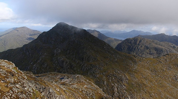
Travel the single track road that wiggles for miles along Loch Arkaig and you’ll know you’re heading somewhere special. The point the tarmac dies isn’t so much the end of the line as the start of new and exciting possibilities. From here several potential routes fan out into Knoydart's well named Rough Bounds, a complex region of twisting glens and gnarled peaks, bogs and cliffs, lochans and snaking sea lochs. Day trips are possible of course, but the area is better suited to long weekends (or longer), and its hefty approach routes are as hard as the peaks themselves. Sgurr na Ciche is the star attraction hereabouts, its distinctive conical summit rising from the head of tidal Loch Nevis to offer one of the most inaccessible of Munro challenges. It is often tackled with the Munros to its east, and done this way it's just a one-day wonder; but the most intriguing of Sgurr na Ciche's neighbours is actually the Corbett Ben Aden, one of the roughest and hardest to reach of Scotland's mountains. You'll be unlikely to knock these two off in a day, so why not take some time over it and enjoy? There are quicker ways than the one described to return home from the summit of Sgurr na Ciche but this circuit hinges on Sourlies bothy (see http://www.mountainbothies.org.uk/bothy-details.asp?bothy_id=112 for more info), the ideal mid-way base. The bothy is itself a long hard walk (or kayak) from anywhere, and the approach covered here is one of the classic Scottish through-routes in its own right.
Detailed description
From the high point descend past Lochan a' Mhaim onto a remote flood plain. It’s easy to lose the path here but don't be drawn into the gorge ahead. The correct route fords the Finiskaig River to the north bank where the trail is once again obvious, running above the gorge. Ignore the stalker's path that turns off right and continue down-glen, descending in zigzags and crossing a footbridge to reach the broad soggy valley at the head of Loch Nevis. Sourlies bothy is by the beach.
First aim for the top of the mountain's well defined northeast ridge. Just before reaching the first minor summit on this ridge veer right, dropping steeply to an obvious grassy terrace. This descends east, soon terminating in a dank crag; pass this on the left (facing out) to reach a safe saddle. Continue east over an ill-defined summit amid complex rock knolls and pond-pitted boggy hollows. From the next saddle start climbing towards Meall a’ Choire Dhuibhe, but before reaching the top turn hard right to contour an obvious grassy line among the crags of its western flank to reach a col below Sgurr na Ciche. It's a long tough slog from here, threading a line between outcrops. Beyond a ridge-crest top is the rocky summit cone, which is breached via a path alongside a dilapidated drystone wall. When the wall slants off left from the crest continue straight up to reach the east end of the final summit ridge. The summit has an isolated feel and stunning views of Knoydart and the Hebrides.
This has been viewed 9,048 times
Download
OS maps and some other mapping apps don't allow waypointsStatistics
Difficulty: SevereDistance: 30.68 miles (49.38 km)
Total ascent: 2,442m
Steepest Gradient: 64% (1 in 2)
Time: 17 hours (Walking)
to rate this walk.
Additional Information
Start/Finish:Road end car park near Strathan at the head of Loch Arkaig, NM987916
Nearest town:
Fort William
Terrain:
A winning combination of bogs, rough ground and steep scrambly slopes. Paths range from very well used to non-existent. River crossings can be hazardous, and may even prove impossible in spate. In poor visibility Ben Aden in particular needs both good map/compass navigation and the ability sniff out a route in complex craggy terrain.
Seasonal variations:
For both hills some basic mountaineering competence would be an advantage in winter conditions, particularly on the ascent of Ben Aden described here. With snow on the ground and short windows of daylight this round would feel testing and particularly remote.
Weather and Hill Conditions: mwis: Northwest Highlands – Met Office: West Highlands
Public transport:
No buses go anywhere near the head of Loch Arkaig; a long walk-in from the railway at Glenfinnan would be your best bet (add a day or two - there are suitable bothies). Alternatively get the boat from Mallaig to Inverie and approach Sourlies from there.
Guidebooks:
Scotland, Chris Townsend, pb.Cicerone http://www.cicerone.co.uk/product/detail.cfm/book/442/title/scotland/refer/ukh
Maps:
OS Explorer 413 (1:25,000), OS Explorer 398 (1:25,000), OS Landranger 40 (1:50,000), OS Landranger 33 (1:50,000) Directory Listings:
Find more Listings near this route Tourist info:
Fort William (0845 22 55 121); Cluanie (01320 340 238)
Further Routes
by Dan Bailey UKH
- A' Chralaig and Mullach Fraoch-choire 4 Dec, 2023
- Meall na Teanga & Sron a' Choire Ghairbh - The Loch Lochy Munros 6 Nov, 2023
- Bynack More 19 Oct, 2023
- Beinn a' Mhuinidh 4 Oct, 2023
- Loch Ossian round - Seven Munros by Train 15 Sep, 2023


