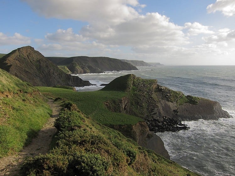
At a whopping 630 miles the South West Coast Path (SWCP) is by far the longest of our official National Trails, and a real classic. But rather than tackle the whole thing in one go most walkers nibble at it in bite-sized chunks. Starting at the historic and almost-too-perfect fishing village of Clovelly, the day-long stretch described here is among the best and wildest of the entire SWCP, following the rugged Culm Coast to the outermost point of the Bristol Channel and on down the weatherbeaten Atlantic seaboard. With its wave-washed slabs, sharp fins and tottering headlands the rock scenery is continually impressive, and keen climbers will particularly enjoy checking out the many highlights. But it's not all about the rock; there are dense mossy oakwoods and breezy clifftop pastures too - plus waterfalls, hidden coves and booming surf. You might even find yourself a cream tea along the way. Does coastal walking get any better than this?
Before getting underway it's worth making your way into Clovelly, where the cobbled 'high street' (car-free) leads steeply downhill between fishermen's cottages to the stone-built harbour. It's a fascinating, ancient place - but probably best enjoyed outside the tourist season.
For more info on the whole 630 miles of the SWCP see here: http://www.southwestcoastpath.com/
Detailed description
This has been viewed 8,006 times
Download
OS maps and some other mapping apps don't allow waypointsStatistics
Difficulty: DifficultDistance: 16.40 miles (26.40 km)
Total ascent: 1,203m
Steepest Gradient: 23% (1 in 4)
Time: 6 – 8 hours (Walking)
to rate this walk.
Additional Information
Start Car park above Clovelly, SS314250; Finish Old Smithy Inn, Darracott (Welcombe), SS231179
Nearest town:
Bude or Bideford
Terrain:
A mix of woodland and clifftop walking, with many short but steep ascents/descents. In wet weather the path can be very muddy in places, and in summer it may get overgrown and a bit nettley here or there. Signposting at trail junctions does not always make the SWCP route obvious, so the map has to be consulted more often than you might think.
Seasonal variations:
A great walk year round, whether on a scorching summer day (beach stops recommended) or in a winter storm.
Public transport:
A bit limited; you'd be better organising two cars or a lift if possible. Stagecoach 319 service runs from Barnstaple to Hartland, via Bideford and Clovelly. There's also a local bus service between Bude and Hartland that'll pick you up at Welcombe Cross on the A39 about 3km east of Welcombe. See http://www.travelinesw.com
Maps:
OS Explorer 126 (1:25,000), OS Explorer 139 (1:25,000), OS Landranger 180 (1:50,000), OS Landranger 190 (1:50,000)
Accommodation:
B&B at the Old Smithy Inn, Welcombe http://www.theoldsmithyinn.co.uk
Elmscott Youth Hostel tel. 01237 441276
No.2 Darracott self-catering accommodation tel. 01288 331560
Leddon Farm caravan and camp site, Welcombe
B&Bs and hotels in Clovelly
Find more Listings near this route
Tourist info:
Bideford (01237 477 676); Torrington (01805 626 140); Braunton (01271 816400)
Further Routes
by Dan Bailey UKH
- A' Chralaig and Mullach Fraoch-choire 4 Dec, 2023
- Meall na Teanga & Sron a' Choire Ghairbh - The Loch Lochy Munros 6 Nov, 2023
- Bynack More 19 Oct, 2023
- Beinn a' Mhuinidh 4 Oct, 2023
- Loch Ossian round - Seven Munros by Train 15 Sep, 2023


