The Awful Hand and Rhinns of Kells Walking

Not counting those who live there, the Southern Uplands are generally neglected by walkers. This vast area has a real backwater feel, yet the best of the hills here easily hold their own with more celebrated summits. The one thing they tend to lack is crowds. In contrast to the generally rolling lay of the land the wild heart of the Galloway Forest Park is strikingly rugged, a knobbly landscape scattered with micro crags and deserted lochans, its lower slopes defended by a winning combination of man eating bog, ankle-twisting tussock and impenetrable conifers. Well I'm sold. A skyline walk around the parallel ranges the Rhinns of Kells and the Awful Hand shows this area at its uncompromising best and includes Merrick, highest summit in southern Scotland. For most teams this will be an overnighter, and it just so happens there's great camping at about the mid-way point (anywhere in stage 4, below).

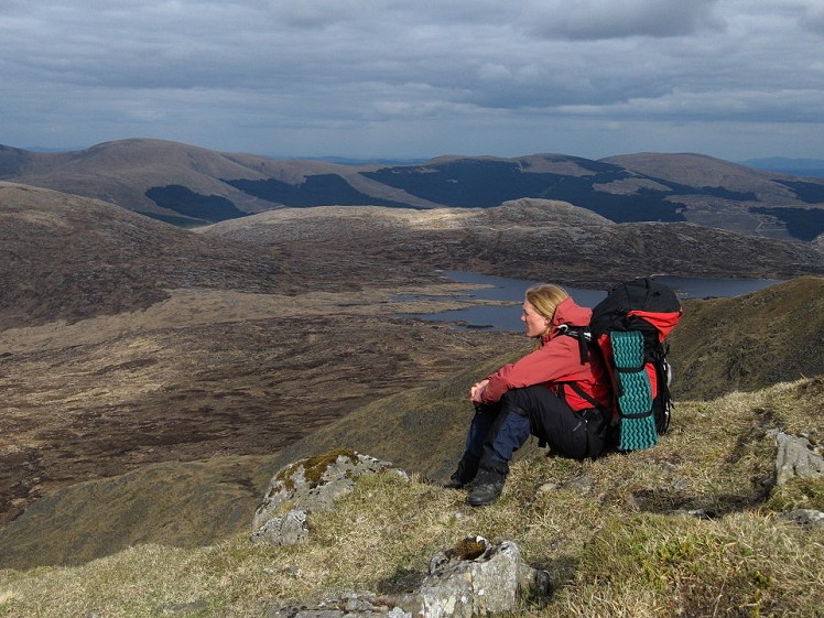
Loch Enoch from Little Spear  © Dan Bailey - UKHillwalking.com
Loch Enoch from Little Spear
Fetching Map

Detailed description

1
NX4444893725 Cars can be parked at many points by the unsurfaced Forest Drive that runs between the tarmac roads at lochs Doon and Bradan. Continue walking west along the track, passing a children's playground above the north shore of Loch Riecawr to reach a junction a few hundred metres further on. Turn left here passing the Rocking Stone (a balanced boulder). Some way short of Tunskeen bothy, the forest opens up on the right.

2
NX4213591924 Leave the track for an intermittent path that ascends west, weaving among outcrops on rough tussocky ground. As height is gained curve gradually left to ascend the north flank of Shalloch on Minnoch, reaching its spacious twin-topped summit with relief. The trig point sits on the slightly lower-looking western top. From the eastern top descend south-southeast, then pass over the smaller hump of Tarfessock. Scattered with rocks and little pools, Tarfessock's broad southeast ridge runs down to a low col below the northern flank of Kirriereoch Hill. Cross a fence and attack the slope head-on, the ground becoming quite steep rocky higher up.

3
NX4209487002 Beyond the next dip rises the bulk of Merrick. A largely grassy ascent leads to the outlying spur of Little Spear, from where a sculpted ridge arcs around a shallow corrie up to Merrick itself.

4
NX4275785542 From the summit trig point descend southeast towards Loch Enoch. The ground soon runs into the rocky knobbles and boggy hollows that characterise the Dungeon Hills, a low but intriguing range squeezed between the Awful Hand and the Rhinns of Kells. This remote granite heartland is where it's at for rock climbers. A sketchy path winds along the rough southern shore of Loch Enoch, past sandy beaches. At the southeast corner of the loch peel right to pass south of Craignairny. Skirt above a steep little crag overlooking the head of the glen of Loch Neldricken, then descend rock steps to a pronounced col at the northern end of Craignaw.

5
NX4542784346 Just below the col a cairn marks the rough, easily-lost descent path east into a corrie. Pass between the craggy bluffs of Craignaw and the Dungeon of Buchan, to reach level ground on the wide marshy trough of the Silver Flowe. Continue east between two small lochs with some bog-related entertainment, to reach Saugh Burn and a forest boundary. A muddy path follows the right edge of a clear-felled area to reach Backhill of Bush, a scruffy bothy in a pretty burnside setting. It was here that the idea of a Mountain Bothies Association was first mooted in the 1960s.

6
NX4805484277 Beyond the bothy go left on a forestry track beside Downies Burn. The track soon veers away from the burn, then passes a junction with a downhill track. At the next junction go right, on a track that curves uphill through the woods for about 2km. Look out on the left for a muddy path that cuts northeast directly uphill along a burn at the edge of a clear-felled area. Above the trees grassy slopes lead to Corserine's south ridge. The expansive domed summit is as smooth as a bowling green.

7
NX4978287059 Continuing north along the spine of the Rhinns of Kells a drop and re-ascent gain the pronounced top of Carlin's Cairn. A carlin is an old hag or witch, and though it's unclear which witch we're talking about she seems to have merited a huge summit cairn. With views of Loch Doon ahead, continue over Meaul to the col below Bow.

8
NX5022292167 There is no hassle-free way from the Rhinns of Kells to Loch Doon, so here's the most direct choice: From the Meaul-Bow col drop northwest to the forest boundary at about NX500926, then ad-lib and hack your way downhill through the forest using burns and fire breaks to meet a forestry track near the loch head. Once free of the trees (phew) pass the buildings at Loch Head and go right at a track junction to cross a bridge over the river of Gala Lane. This track heads north to meet Forest Drive in a little under 2km. The car's not far now.

This has been viewed 9,639 times


Further Routes

by Dan Bailey UKH


Loading Notifications...
Facebook Twitter Copy Email