Rocktype UNKNOWN
Altitude 1605m a.s.l
Faces N
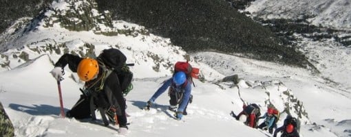
Cathedral Gully, Katahdin, Maine, US © damljano
Summit of this hill
This summit has been climbed in 6 logbooks.Hill features
The highest summit in Maine and terminus of the Appalachian Trail, Katahdin ("Great One"), consists of a high granite plateau with a hook-shaped southern extension. The main summit, Baxter Peak, is where the hook joins the plateau, the hook being the famous Knife Edge.
The Northwest Basin is seriously remote but more broken than the other two basins. On the east side, the Great Basin splits higher up into North and South Basins, separated by Hamlin Ridge, which runs up to the subsidiary top Hamlin Peak. There are major crags with routes of over 300m in both North and South Basins. Compasses have been known to malfunction around the summit.
Approach notes
In Baxter State Park (203,000 acres), 25 miles north of Millinocket. The climbing areas and the usual routes up the hill (other than the AT) are approached from Roaring Brook Campground at the end of the dirt road coming in from the SE.
A path leads from here to Chimney Pond Campground (5.5km). Paths from there lead:
- up to Pamola Peak for the Knife Edge (which can also be reached directly from Roaring Brook by the Helon Taylor Trail).
- into South Basin and up to the summit via either Cathedral Ridge (a scramble) or the Saddle Trail (a walk). The climbs directly under the main summit are reached via this route.
- up to Hamlin Peak via the Hamlin Ridge.
- up to the lip of North Basin, from where a tiny path (which people usually fail to find) leads to the climbs there.
Route Cards
| There are no comments from visitors to this hill. |
Summits, Scrambles, and Easy Climbs on this hill
| Name | Grade | Stars | Type | Logs | Partner Ascents |
|---|
These routes you have climbed by seconding or top-roping.
These routes you have Dogged.
These routes you Did not Finish.
Routes are waiting to be checked by a crag moderator, and may not be accurate. Routes can't be verified by a crag moderator, and they need more information to confirm it. Routes are no longer climbable.