


Kalymnos may be a world class sport climbing destination, but there's far more to it than that. Did you know that this rugged Greek island is also home to stunning walks, from short strolls to the 100km Kalymnos Trail? Us neither. Weaving through parched limestone hills, past huge crags and deserted Aegean beaches, this tough route even involves some basic scrambling. Carl Dawson, who created the Kalymnos Trail and has written a new guidebook to it, lifts the lid on this secret Mediterranean classic.
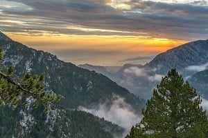
Kalymnos, a small but mountainous Greek island, is already famous as a top international venue for sports climbing. But it is virtually unknown by non-Greeks for its hiking. True, many climbers venture along some paths on their 'active rest days' but few hikers have recognised the opportunities for walking through the herb-covered phrygana on the hillsides here; the Turkish coastline framing the eastern horizon, and, to the west, well, just the endless islands of the Aegean.

© Carl Dawson
"A lot is demanded from the hiker, but in return it provides a unique and memorable experience of mountain, sun and shimmering sea"
One walk which has always been popular though is the so-called Italian Path, improved during the Italian occupation in the first half of the 20th century but actually the original and, until recently, the only non-sea link between the island capital, Pothia, and the verdant Vathy Valley. Paved with natural stone along almost all its 4km, this provides most people with their first introduction to mountain walking on Kalymnos.
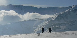
Perhaps the second most popular walk is the wide stony trail along the seacliffs from Kantouni Beach to the fabulously-sited chapel of Saint Photis, a 4km round trip which can be undertaken by almost everyone. At the other end of the spectrum is an ascent of the 2145 foot Patela South: you are most likely to have 'The Kneecap" to yourself on the 7km return trip up this pathless peak, especially if you twist your way up through the limestone towers along the north ridge. You will have noticed that the distances quoted here seem very short compared with hill walks in other areas… but don't be fooled: Naithsmith's Rule doesn't seem to apply to the rugged limestone trails hereabouts, so you need to rethink times on the hill!

© Carl Dawson
There are other paths shown on the older maps to the island, some great, some imaginary. This year however my new book, The Kalymnos Trail, shows new possibilities for the trekker in the form of a 100km trail that links virtually all the classic paths and sites of interest via much older, often half-hidden shepherds' and goat trails. A lot is demanded from the hiker but, in return, it provides a unique and memorable experience of mountain, sun and shimmering sea.
The Kalymnos Trail
When I first came to Kalymnos in 2002, encouraged by an early magazine article (was it in Mountain magazine?) and with the first pamphlet-like climbing topo, I didn't know then how Kalymnos would grow to become a major part of my life. I immediately loved the climbing though and 'because it was there' spent those so-called rest days scrambling up to the top of the main escarpment above the west coast, checking out the 'paths' of the overly optimistic maps of the time.
Over many visits, hours spent 'on the mountain' started to accumulate and the idea emerged that a continuous trail might be possible. To me, the ancient paths deserved walking and preserving, and so 'creating' a trail was a good way to celebrate them. Flight times back to the UK were filled scribbling on maps, trying to link all the best sections into one single loop. But it never quite 'worked'.
"The ancient paths deserved walking and preserving, and so 'creating' a trail was a good way to celebrate them"
The missing link was the east coast of the island. The maps showed no paths and the precipitous coastline appeared daunting. Other hikers I'd spoken to said that it was 'impassable and impossible'… no way could one get between the hamlet of Palionisos and the remote, stunningly beautiful, uninhabited fjord-like inlet at Pezonda. But a chance encounter with a local goat herder elicited a vital clue. A way was possible but it was πολý δýσκολο. In other words, very difficult. But, if the goats could do it, and if the villagers in olden times could make it over the sea cliffs to visit the doctor in Vathy, then so could a determined hiker.

© Carl Dawson |

© Carl Dawson |
Last summer, getting up seriously early in the mornings, the search was on. The Palionisos sea cliffs were found to be 'interesting' but the scratchmarks of goat hooves gave the game away and their path was eventually found through the sea cliffs. Then there was the Juniper Maze… But the big challenge was finding a way down into Pezonda Bay from the north-west. Huge crags, dead-end scree gullies. Fortunately I'd spotted a possible way down some years before whilst walking on the mountains to the south. And so a slightly spooky descent, alone and where a broken ankle would have been 'difficult', led to an impasse a couple of hundred feet above the sea. But the Greek gods favoured this Trail I think, and a Fortuitous Terrace led surprisingly easily, out under amazing crags, to reach the empty beaches and cobalt waters of Pezonda. And with this, the Kalymnos Trail was complete. I pulled my boots off and walked fully clothed into the Aegean: so hot but so happy.
So: the Kalymnos Trail. Although some of the 10 sections are fairly easy walking (it includes for example the previously mentioned Italian Path), other days consist of tough walking on stony trails or involve route finding through pathless mountain terrain. In several places scrambling skills are required. If you are used to Jack's Rake or Bristly Ridge then with care you would be OK, but if I had inexperienced or nervous scramblers with me I'd perhaps want a short length of rope on a couple of occasions.
"If the goats could do it then so could a determined hiker"

© Carl Dawson
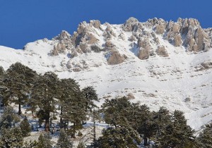
The Trail is varied and each section offers something different. Some days are coastal walks, cutting through thousand-foot sea cliffs. Others are mountain days, reaching steep little peaks of around 1500-2500 feet, with 360-degree ocean views. On other days, the emphasis is on cultural remains: Byzantine ruins, Crusader castles, Early Christian basilicas, Bronze Ages sites and the like. And Greek island beaches of course.
There are longer trails in the world. There are undoubtedly 'prettier' trails. But for me, the combination of harsh yet beautiful mountains surrounded by vast ocean, all under a Greek sun, is unrivalled. As I'm following the old paths to now-abandoned hill villages which look out beyond the rim of Europe, I've found little to match this unique sense of history, original mountain landscape and tranquillity.
When to go
Although I was crazy enough to do the final research for The Trail in August (by walking from 6am to 11am), most trekkers would find this season 'demanding'. The ideal times are those shared by climbers ie March-early June (which is when the island is in full bloom) or late September-end of November (ideal sea temperature for après-hike swims). December-February is usually mild but can be wet.
Getting there
Most visitors from the UK fly to Kos from where a fairly short ferry ride takes you to Pothia, the main port on Kalymnos. There are other possible travel options and it is worth checking out the excellent climbing website, climbkalymnos.com, which gives travel alternatives as well as other practical advice.
What to bring
Kalymnos can be a windy island (which is usually a blessing as the meltemi keeps temperatures in the sun down to manageable levels). So make sure you bring a wind-proof top. Rarely is heavy-duty mountain clothing needed. Kalymnos limestone is much sharper than the Pennine equivalent, and the trails are often rough so bring either good quality approach shoes or light boots. On the rockier trails I take a thin leather glove (for reasons which become apparent) and one trekking pole. A superb 1: 25 000 map of the island (get the 2015 edition) can be obtained from Terrain Maps or from many of the shops on the island. The Kalymnos Trail is marked on this edition, though the book describing the trail will give you much more information on the intricacies of the route and the island in general.
Food, drink and accommodation
Accommodation, travel and food on the island is not a problem if you stay at one of the (lively, in season) west coast villages and use scooters (widely available) to reach sections of the trail on a daily basis. Really hard-core walkers wanting to do The Trail in a continuous push have a challenge as accommodation is not readily available in the smaller villages (especially in winter). Carrying sufficient water is even more of a challenge though suggestions of how to deal with this are described in the book.
About the Guidebook
The Kalymnos Trail details the route in ten full-day or half-day sections. The book contains 160 pages in an easy-to-carry format and is well illustrated with maps and photos. An introduction to the island and hints on a successful completion of The Trail are included as well as a brief appendix listing other walks on the island. Published in 2015 by Terrain Maps, it is available through Cordee for £12 plus p&p, and in shops on Kalymnos - Masouri and Pothia. Visit the webpage or Facebook for updates. Feedback from UKHillwalking users is always welcome.

About Carl Dawson
Carl had a classical mountain upbringing in the 1960s, starting with hillwalking and then progressing to rock climbing in the north of England and Wales. He has contributed to several guidebooks over the years and is still 'active'. Currently, he and his wife Ruth split their time between Holmfirth in West Yorkshire and Armeos on Kalymnos, where cultivating a limestone pavement, 'projecting' on steep tufa and searching out old shepherds' trails occupy much of their time.


Comments